Estimated Value: $992,000 - $1,190,000
4
Beds
2
Baths
1,735
Sq Ft
$624/Sq Ft
Est. Value
About This Home
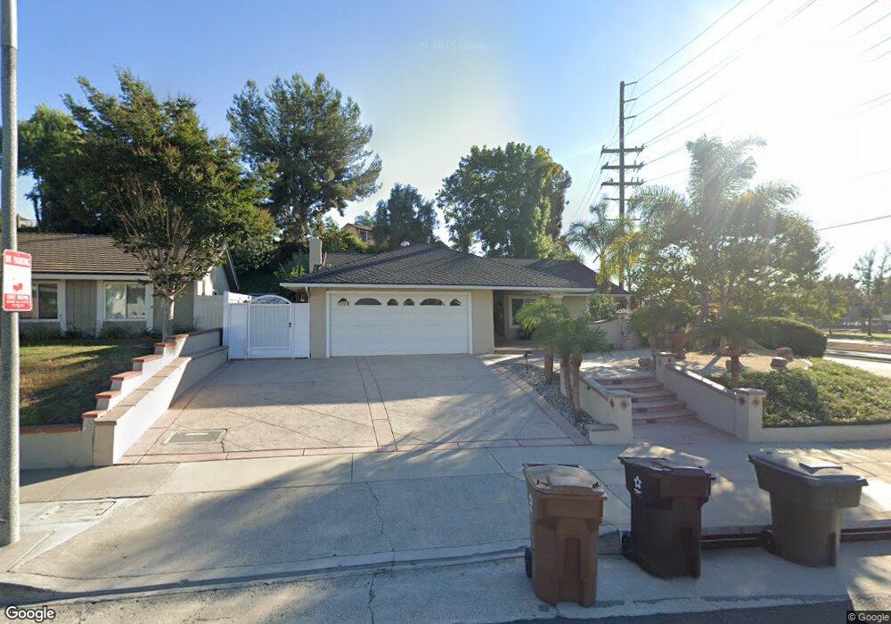
This home is located at 1920 Chevy Chase Dr, Brea, CA 92821 and is currently estimated at $1,082,417, approximately $623 per square foot. 1920 Chevy Chase Dr is a home located in Orange County with nearby schools including Brea Country Hills Elementary School, Brea Junior High School, and Brea-Olinda High School.
Ownership History
Date
Name
Owned For
Owner Type
Purchase Details
Closed on
Mar 8, 2010
Sold by
Maciel Peter M and Maciel Alicia A
Bought by
Maciel Peter M and Maciel Alicia Z
Current Estimated Value
Purchase Details
Closed on
Jun 1, 1999
Sold by
Gursahani Krishan C and Gursahani Meena K
Bought by
Maciel Peter M and Maciel Alicia Z
Home Financials for this Owner
Home Financials are based on the most recent Mortgage that was taken out on this home.
Original Mortgage
$238,500
Outstanding Balance
$63,886
Interest Rate
7.24%
Estimated Equity
$1,018,531
Create a Home Valuation Report for This Property
The Home Valuation Report is an in-depth analysis detailing your home's value as well as a comparison with similar homes in the area
Home Values in the Area
Average Home Value in this Area
Purchase History
| Date | Buyer | Sale Price | Title Company |
|---|---|---|---|
| Maciel Peter M | -- | None Available | |
| Maciel Peter M | $246,000 | Southland Title Corporation |
Source: Public Records
Mortgage History
| Date | Status | Borrower | Loan Amount |
|---|---|---|---|
| Open | Maciel Peter M | $238,500 |
Source: Public Records
Tax History
| Year | Tax Paid | Tax Assessment Tax Assessment Total Assessment is a certain percentage of the fair market value that is determined by local assessors to be the total taxable value of land and additions on the property. | Land | Improvement |
|---|---|---|---|---|
| 2025 | $4,378 | $378,083 | $238,153 | $139,930 |
| 2024 | $4,378 | $370,670 | $233,483 | $137,187 |
| 2023 | $4,255 | $363,402 | $228,904 | $134,498 |
| 2022 | $4,211 | $356,277 | $224,416 | $131,861 |
| 2021 | $4,131 | $349,292 | $220,016 | $129,276 |
| 2020 | $4,103 | $345,711 | $217,760 | $127,951 |
| 2019 | $3,995 | $338,933 | $213,490 | $125,443 |
| 2018 | $3,934 | $332,288 | $209,304 | $122,984 |
| 2017 | $3,859 | $325,773 | $205,200 | $120,573 |
| 2016 | $3,783 | $319,386 | $201,177 | $118,209 |
| 2015 | $3,729 | $314,589 | $198,155 | $116,434 |
| 2014 | $3,621 | $308,427 | $194,273 | $114,154 |
Source: Public Records
Map
Nearby Homes
- 1796 Ravencrest Dr
- 136 Donnybrook Rd
- 2304 Carrotwood Dr
- 2418 Rainbow Ln
- 2851 Rolling Hills Dr Unit 178
- 2851 Rolling Hills Dr Unit 257
- 2851 Rolling Hills Dr Unit 248
- 2851 Rolling Hills Dr
- 2849 Tarragon Ct
- 2826 Lemonwood Ct
- 3054 Associated Rd Unit 20
- 570 Olive Ave
- 2583 Sandpebble Ln
- 3000 Associated Rd Unit 60
- 2775 Pine Creek Cir Unit 116
- 213 Appalachian Cir
- 206 Allegheny Cir
- 2733 Quail Ridge Cir Unit 32
- 688 Buttonwood Dr
- 520 N Bardsdale Place
- 1950 Chevy Chase Dr
- 1939 Heather Cir
- 1951 Heather Cir
- 1960 Chevy Chase Dr
- 1953 Heather Cir
- 1931 Chevy Chase Dr
- 1930 Heather Cir
- 1978 Chevy Chase Dr
- 1955 Chevy Chase Dr
- 1975 Heather Cir
- 1940 Heather Cir
- 1969 Chevy Chase Dr
- 315 Dover Ave
- 325 Dover Ave
- 1952 Heather Cir
- 355 Hillhaven Cir
- 303 Dover Ave
- 1964 Heather Cir
- 333 Dover Ave
- 360 Hillhaven Cir
Your Personal Tour Guide
Ask me questions while you tour the home.