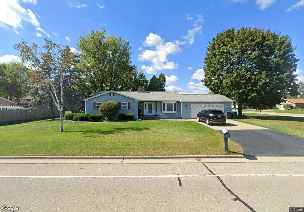
1921 N Perkins St Appleton, WI 54914
Estimated Value: $305,206 - $324,000
3
Beds
2
Baths
2,019
Sq Ft
$156/Sq Ft
Est. Value
About This Home
This home is located at 1921 N Perkins St, Appleton, WI 54914 and is currently estimated at $315,552, approximately $156 per square foot. 1921 N Perkins St is a home located in Outagamie County with nearby schools including Highlands Elementary School, Wilson Middle School, and Appleton West High School.
Ownership History
Date
Name
Owned For
Owner Type
Purchase Details
Closed on
Jan 1, 2026
Sold by
Oshea Kevin J and Oshea Christina A
Bought by
Mayo Mark and Mayo Katie
Current Estimated Value
Purchase Details
Closed on
May 29, 2009
Sold by
Homeowning Solutions Llc
Bought by
O'Shea Kevin J and O'Shea Christina A
Purchase Details
Closed on
Apr 23, 2009
Sold by
Fannie Mae
Bought by
Homeowning Solutions Llc
Purchase Details
Closed on
Feb 11, 2009
Sold by
Thao Leng
Bought by
Federal National Mortgage Association
Purchase Details
Closed on
Apr 25, 2007
Sold by
Smith Lawrence A and Smith Ellen R
Bought by
Thao Leng
Create a Home Valuation Report for This Property
The Home Valuation Report is an in-depth analysis detailing your home's value as well as a comparison with similar homes in the area
Home Values in the Area
Average Home Value in this Area
Purchase History
| Date | Buyer | Sale Price | Title Company |
|---|---|---|---|
| Mayo Mark | $285,000 | None Listed On Document | |
| O'Shea Kevin J | $133,200 | -- | |
| Homeowning Solutions Llc | $111,000 | -- | |
| Federal National Mortgage Association | $150,000 | -- | |
| Thao Leng | $149,900 | -- |
Source: Public Records
Tax History
| Year | Tax Paid | Tax Assessment Tax Assessment Total Assessment is a certain percentage of the fair market value that is determined by local assessors to be the total taxable value of land and additions on the property. | Land | Improvement |
|---|---|---|---|---|
| 2024 | $2,918 | $164,900 | $28,500 | $136,400 |
| 2023 | $2,901 | $164,900 | $28,500 | $136,400 |
| 2022 | $2,851 | $164,900 | $28,500 | $136,400 |
| 2021 | $2,804 | $164,900 | $28,500 | $136,400 |
| 2020 | $2,872 | $164,900 | $28,500 | $136,400 |
| 2019 | $2,866 | $151,100 | $23,600 | $127,500 |
| 2018 | $2,966 | $151,100 | $23,600 | $127,500 |
| 2017 | $2,889 | $151,100 | $23,600 | $127,500 |
| 2016 | $2,874 | $151,100 | $23,600 | $127,500 |
| 2015 | $2,930 | $151,100 | $23,600 | $127,500 |
| 2014 | $2,660 | $137,800 | $23,600 | $114,200 |
| 2013 | $2,688 | $137,800 | $23,600 | $114,200 |
Source: Public Records
Map
Nearby Homes
- 1729 N Blossom Dr
- 1501 N Lynndale Dr
- 2401 W Roberts Ave
- 1813 W Summer St
- 1715 W Wisconsin Ave
- 2119 N Cloudview Dr
- 1913 N Outagamie St
- 807 N Badger Ave
- 904 N Gillett St
- 1632 W Cloverdale Dr
- 1315 W Summer St
- 2980 W Northland Ave
- 1201 W Brewster St
- 1201 W Hawes Ave
- 1235 W Frances St
- 1018 W Parkway Blvd
- 303 N Outagamie St
- 914 W Brewster St
- 1019 W Oklahoma St
- 2618 W Sunnyview Cir
- 1518 N Perkins St
- 1519 N Perkins St
- 1630 N Perkins St
- 1722 N Perkins St
- 1910 N Perkins St
- 1928 N Perkins St
- 1520 N Perkins St
- 2139 W Harvest Dr
- 2225 W Harvest Dr
- 2131 W Harvest Dr
- 2233 W Harvest Dr
- 1618 N Perkins St
- 2224 W Jonathon Dr
- 2224 W Harvest Dr
- 2232 W Jonathon Dr
- 2123 W Harvest Dr
- 2241 W Harvest Dr
- 2130 W Harvest Dr
- 2232 W Harvest Dr
- 2240 W Jonathon Dr
Your Personal Tour Guide
Ask me questions while you tour the home.