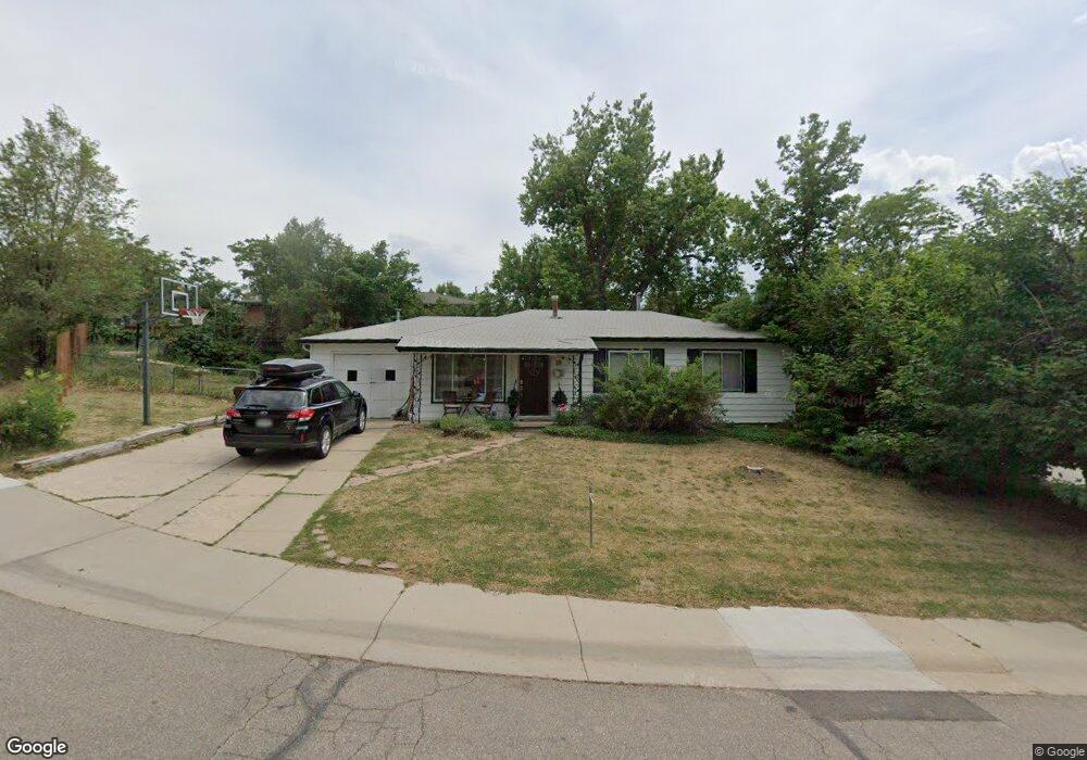
1922 Tyler Rd Boulder, CO 80304
Central Boulder NeighborhoodEstimated Value: $1,225,000 - $1,450,000
3
Beds
1
Bath
1,370
Sq Ft
$956/Sq Ft
Est. Value
About This Home
This home is located at 1922 Tyler Rd, Boulder, CO 80304 and is currently estimated at $1,309,868, approximately $956 per square foot. 1922 Tyler Rd is a home located in Boulder County with nearby schools including Whittier Elementary School, Casey Middle School, and Boulder High School.
Ownership History
Date
Name
Owned For
Owner Type
Purchase Details
Closed on
Aug 2, 2013
Sold by
The Noreen L Neeson Trust
Bought by
Biderman Denna
Current Estimated Value
Home Financials for this Owner
Home Financials are based on the most recent Mortgage that was taken out on this home.
Original Mortgage
$400,000
Outstanding Balance
$291,919
Interest Rate
3.93%
Mortgage Type
New Conventional
Estimated Equity
$1,017,949
Purchase Details
Closed on
Feb 19, 1993
Bought by
Biderman Denna and Biderman Theodore
Purchase Details
Closed on
Jun 9, 1982
Bought by
Biderman Denna and Biderman Theodore
Purchase Details
Closed on
Sep 27, 1978
Bought by
Biderman Denna and Biderman Theodore
Create a Home Valuation Report for This Property
The Home Valuation Report is an in-depth analysis detailing your home's value as well as a comparison with similar homes in the area
Home Values in the Area
Average Home Value in this Area
Purchase History
| Date | Buyer | Sale Price | Title Company |
|---|---|---|---|
| Biderman Denna | $500,000 | Land Title Guarantee Company | |
| Biderman Denna | -- | -- | |
| Biderman Denna | -- | -- | |
| Biderman Denna | $60,100 | -- |
Source: Public Records
Mortgage History
| Date | Status | Borrower | Loan Amount |
|---|---|---|---|
| Open | Biderman Denna | $400,000 |
Source: Public Records
Tax History
| Year | Tax Paid | Tax Assessment Tax Assessment Total Assessment is a certain percentage of the fair market value that is determined by local assessors to be the total taxable value of land and additions on the property. | Land | Improvement |
|---|---|---|---|---|
| 2025 | $8,328 | $89,844 | $68,613 | $21,231 |
| 2024 | $8,328 | $89,844 | $68,613 | $21,231 |
| 2023 | $8,183 | $94,758 | $72,253 | $26,190 |
| 2022 | $7,125 | $76,721 | $56,392 | $20,329 |
| 2021 | $6,794 | $78,929 | $58,015 | $20,914 |
| 2020 | $5,987 | $68,783 | $49,764 | $19,019 |
| 2019 | $5,896 | $68,783 | $49,764 | $19,019 |
| 2018 | $5,445 | $62,798 | $38,160 | $24,638 |
| 2017 | $5,274 | $69,427 | $42,188 | $27,239 |
| 2016 | $5,058 | $58,427 | $33,273 | $25,154 |
| 2015 | $4,789 | $40,102 | $18,228 | $21,874 |
| 2014 | $3,372 | $40,102 | $18,228 | $21,874 |
Source: Public Records
Map
Nearby Homes
- 1895 Alpine Ave Unit G22
- 1895 Alpine Ave Unit G21
- 1895 Alpine Ave Unit E18
- 2003 Balsam Dr
- 2870 18th St
- 1749 Alpine Ave Unit 10
- 2324 19th St
- 2085 Balsam Dr
- 2230 20th St
- 2965 17th St
- 2240 Bluff St
- 2340 Panorama Ave
- 2236 17th St
- 2901 Lorraine Ct
- 1526 Sunset Blvd
- 1709 Pine St Unit 3
- 1412 Elder Ave
- 3150 18th St
- 1938 Spruce St
- 3055 23rd St
Your Personal Tour Guide
Ask me questions while you tour the home.