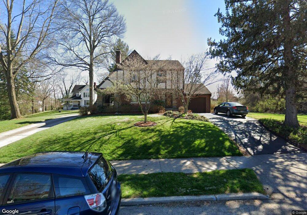
1925 Compton Rd Cincinnati, OH 45231
Estimated Value: $242,000 - $261,000
3
Beds
2
Baths
1,620
Sq Ft
$156/Sq Ft
Est. Value
About This Home
This home is located at 1925 Compton Rd, Cincinnati, OH 45231 and is currently estimated at $252,240, approximately $155 per square foot. 1925 Compton Rd is a home located in Hamilton County with nearby schools including Mt Healthy High School, Central Montessori Academy, and Our Lady of Grace Catholic School.
Ownership History
Date
Name
Owned For
Owner Type
Purchase Details
Closed on
Sep 20, 1996
Sold by
Clepper Bruce D and Clepper Shana K
Bought by
Trentman John and Trentman Eva
Current Estimated Value
Home Financials for this Owner
Home Financials are based on the most recent Mortgage that was taken out on this home.
Original Mortgage
$90,000
Outstanding Balance
$5,128
Interest Rate
8%
Estimated Equity
$247,112
Create a Home Valuation Report for This Property
The Home Valuation Report is an in-depth analysis detailing your home's value as well as a comparison with similar homes in the area
Home Values in the Area
Average Home Value in this Area
Purchase History
| Date | Buyer | Sale Price | Title Company |
|---|---|---|---|
| Trentman John | $100,000 | -- |
Source: Public Records
Mortgage History
| Date | Status | Borrower | Loan Amount |
|---|---|---|---|
| Open | Trentman John | $90,000 |
Source: Public Records
Tax History
| Year | Tax Paid | Tax Assessment Tax Assessment Total Assessment is a certain percentage of the fair market value that is determined by local assessors to be the total taxable value of land and additions on the property. | Land | Improvement |
|---|---|---|---|---|
| 2025 | $3,740 | $71,387 | $9,496 | $61,891 |
| 2023 | $3,751 | $71,387 | $9,496 | $61,891 |
| 2022 | $3,183 | $43,376 | $9,303 | $34,073 |
| 2021 | $3,105 | $43,376 | $9,303 | $34,073 |
| 2020 | $3,188 | $43,376 | $9,303 | $34,073 |
| 2019 | $2,675 | $38,385 | $8,232 | $30,153 |
| 2018 | $2,692 | $38,385 | $8,232 | $30,153 |
| 2017 | $2,540 | $38,385 | $8,232 | $30,153 |
| 2016 | $2,515 | $37,513 | $7,588 | $29,925 |
| 2015 | $2,531 | $37,513 | $7,588 | $29,925 |
| 2014 | $2,517 | $37,513 | $7,588 | $29,925 |
| 2013 | $2,831 | $42,630 | $8,624 | $34,006 |
Source: Public Records
Map
Nearby Homes
- 1967 Compton Rd
- 1980 Stevens Ave
- 1725 Hastings Ave
- 7310 Forest Ave
- 7718 Hamilton Ave
- 9125 Tag Dr
- 1545 Mcmakin Ave
- 1650 Joseph Ct
- 1625 Joseph Ct
- 7404 Joseph St
- 7508 Elizabeth St
- 2175 Carlsbory Dr
- 9369 Ranchill Dr
- 1461 Kinney Ave
- 8724 Neptune Dr
- 7274 Elizabeth St
- 1626 Flora Ave
- 1458 Van Fleet Ave
- 1481 Saint Clair Ave
- 8729 Morningstar Ln
- 1915 Compton Rd
- 1922 Compton Rd
- 1936 Compton Rd
- 1940 Compton Rd
- 1941 Compton Rd
- 1829 Compton Rd
- 1952 Compton Rd
- 1900 Compton Rd
- 7509 Maple Ave
- 1959 Compton Rd
- 1956 Compton Rd
- 7505 Maple Ave
- 7501 Maple Ave
- 1814 Compton Rd Unit 1
- 1814 Compton Rd
- 1926 Stevens Ave
- 1823 Compton Rd
- 7441 Mallory Ln
- 7428 Park Ave
- 1958 Compton Rd
Your Personal Tour Guide
Ask me questions while you tour the home.