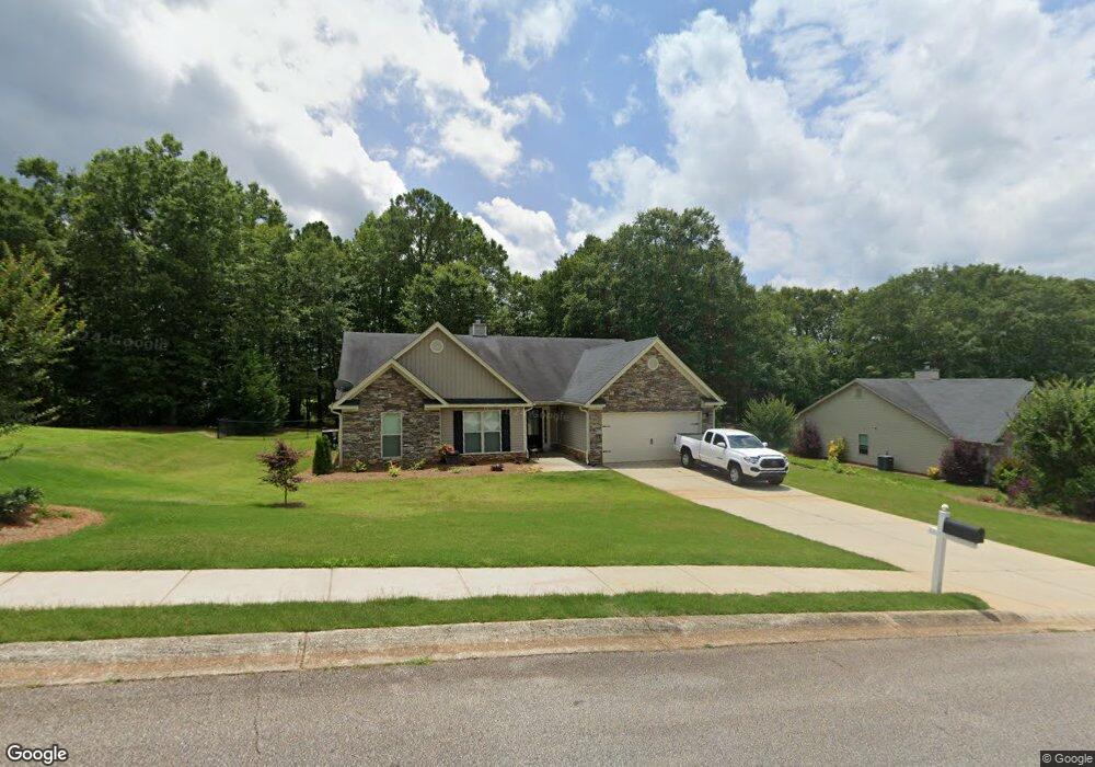
1935 Paynes Point Unit 76 Winder, GA 30680
Estimated Value: $368,000 - $395,000
4
Beds
3
Baths
2,200
Sq Ft
$172/Sq Ft
Est. Value
About This Home
This home is located at 1935 Paynes Point Unit 76, Winder, GA 30680 and is currently estimated at $377,446, approximately $171 per square foot. 1935 Paynes Point Unit 76 is a home located in Barrow County with nearby schools including Statham Elementary School, Bear Creek Middle School, and Winder-Barrow High School.
Ownership History
Date
Name
Owned For
Owner Type
Purchase Details
Closed on
Aug 19, 2016
Sold by
Southfork Homes Llc
Bought by
Dumit Charles J
Current Estimated Value
Home Financials for this Owner
Home Financials are based on the most recent Mortgage that was taken out on this home.
Original Mortgage
$174,704
Outstanding Balance
$139,258
Interest Rate
3.45%
Mortgage Type
New Conventional
Estimated Equity
$238,188
Purchase Details
Closed on
May 9, 2016
Sold by
Sugarloaf East Llc
Bought by
Southfork Homes Llc
Purchase Details
Closed on
Dec 22, 2010
Sold by
State Bank & Trust Co
Bought by
Sugarloaf East Llc
Purchase Details
Closed on
Dec 7, 2009
Sold by
Lcs Llc
Bought by
State Bank & Trust Co
Purchase Details
Closed on
Aug 2, 2006
Sold by
Reece Deborah P
Bought by
Lcs Llc
Create a Home Valuation Report for This Property
The Home Valuation Report is an in-depth analysis detailing your home's value as well as a comparison with similar homes in the area
Home Values in the Area
Average Home Value in this Area
Purchase History
| Date | Buyer | Sale Price | Title Company |
|---|---|---|---|
| Dumit Charles J | $169,900 | -- | |
| Southfork Homes Llc | $147,000 | -- | |
| Sugarloaf East Llc | $3,700 | -- | |
| State Bank & Trust Co | -- | -- | |
| Lcs Llc | -- | -- |
Source: Public Records
Mortgage History
| Date | Status | Borrower | Loan Amount |
|---|---|---|---|
| Open | Dumit Charles J | $174,704 |
Source: Public Records
Tax History Compared to Growth
Tax History
| Year | Tax Paid | Tax Assessment Tax Assessment Total Assessment is a certain percentage of the fair market value that is determined by local assessors to be the total taxable value of land and additions on the property. | Land | Improvement |
|---|---|---|---|---|
| 2024 | $2,840 | $111,616 | $19,200 | $92,416 |
| 2023 | $2,840 | $112,016 | $19,200 | $92,816 |
| 2022 | $3,031 | $103,425 | $19,200 | $84,225 |
| 2021 | $2,761 | $88,456 | $19,200 | $69,256 |
| 2020 | $2,494 | $79,269 | $16,000 | $63,269 |
| 2019 | $2,538 | $79,269 | $16,000 | $63,269 |
| 2018 | $2,326 | $73,075 | $12,800 | $60,275 |
| 2017 | $1,993 | $68,458 | $16,000 | $52,458 |
| 2016 | $323 | $7,680 | $7,680 | $0 |
| 2015 | $233 | $7,680 | $7,680 | $0 |
| 2014 | $82 | $2,600 | $2,600 | $0 |
| 2013 | -- | $2,600 | $2,600 | $0 |
Source: Public Records
Map
Nearby Homes
- 1295 Double Bridges Rd
- 207 Cedar Grove Church Rd
- 113 Platte St
- 1431 Solomon Dr
- 1453 Solomon Dr
- 1023 Solomon Ct
- 670 Cedar Grove Church Rd
- 385 Finch Landing Rd
- 670 Cedar Grove Church Rd
- 212 Rainbow Ln
- 1415 Red Oak Way
- 1724 Cedar Grove Church Rd
- 1642 White Oak Dr
- 1914 Hearthstone Ct
- 330 Anchors Way
- 51 Brockton Way Unit 2
- 1212 Highway 211 NE
- 1226 Highway 211 NE
- 315 Paige Way
- 1593 Highway 82
- 1935 Paynes Point
- 1933 Paynes Point
- 1933 Paynes Point Unit 77
- 1937 Paynes Point Unit 75
- 1937 Paynes Point
- 1931 Paynes Point Unit 78
- 1931 Paynes Point
- 1939 Paynes Point
- 1939 Paynes Point Unit 74
- 1944 Paynes Point Unit 38
- 1944 Paynes Point
- 1934 Paynes Point
- 1934 Paynes Point Unit 37
- 1934 Paynes Point
- 1929 Paynes Point Unit 79
- 1929 Paynes Point
- 1932 Paynes Point Unit 36
- 1932 Paynes Point
- 1946 Paynes Point Unit 39
- 1946 Paynes Point