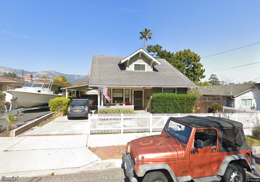
1936 Mountain Ave Santa Barbara, CA 93101
Westside NeighborhoodEstimated Value: $1,589,000 - $1,979,000
3
Beds
2
Baths
1,658
Sq Ft
$1,063/Sq Ft
Est. Value
About This Home
This home is located at 1936 Mountain Ave, Santa Barbara, CA 93101 and is currently estimated at $1,762,864, approximately $1,063 per square foot. 1936 Mountain Ave is a home located in Santa Barbara County with nearby schools including Harding University Partnership, La Cumbre Junior High School, and San Marcos Senior High School.
Ownership History
Date
Name
Owned For
Owner Type
Purchase Details
Closed on
Oct 23, 2000
Sold by
Gregory Melvin J
Bought by
Cahill C Kevin and Cahill Karen P
Current Estimated Value
Home Financials for this Owner
Home Financials are based on the most recent Mortgage that was taken out on this home.
Original Mortgage
$479,200
Outstanding Balance
$177,256
Interest Rate
8.12%
Estimated Equity
$1,585,608
Purchase Details
Closed on
Dec 6, 1999
Sold by
Gregory Melvin J
Bought by
Gregory Melvin J
Create a Home Valuation Report for This Property
The Home Valuation Report is an in-depth analysis detailing your home's value as well as a comparison with similar homes in the area
Home Values in the Area
Average Home Value in this Area
Purchase History
| Date | Buyer | Sale Price | Title Company |
|---|---|---|---|
| Cahill C Kevin | $599,000 | Fidelity National Title Co | |
| Gregory Melvin J | -- | -- |
Source: Public Records
Mortgage History
| Date | Status | Borrower | Loan Amount |
|---|---|---|---|
| Open | Cahill C Kevin | $479,200 |
Source: Public Records
Tax History
| Year | Tax Paid | Tax Assessment Tax Assessment Total Assessment is a certain percentage of the fair market value that is determined by local assessors to be the total taxable value of land and additions on the property. | Land | Improvement |
|---|---|---|---|---|
| 2025 | $9,397 | $902,580 | $452,044 | $450,536 |
| 2023 | $9,397 | $867,534 | $434,492 | $433,042 |
| 2022 | $9,068 | $850,524 | $425,973 | $424,551 |
| 2021 | $8,859 | $833,848 | $417,621 | $416,227 |
| 2020 | $8,767 | $825,299 | $413,339 | $411,960 |
| 2019 | $8,615 | $809,118 | $405,235 | $403,883 |
| 2018 | $8,493 | $793,254 | $397,290 | $395,964 |
| 2017 | $8,212 | $777,700 | $389,500 | $388,200 |
| 2016 | $8,064 | $762,452 | $381,863 | $380,589 |
| 2014 | $7,846 | $736,291 | $368,761 | $367,530 |
Source: Public Records
Map
Nearby Homes
- 1815 Mountain Ave
- 1010 Portesuello Ave
- 834 W Valerio St
- 36 Tinker Way
- 711 Eucalyptus Ave
- 1144 Portesuello Ave
- 1275 Calle Cerrito
- 610 W Valerio St
- 2117 Oak Park Ln
- 1545 W Valerio St
- 2019 Castillo St
- 2203 Parkway Dr
- 714 W Sola St
- 1324 Kenwood Rd
- 2549 Treasure Dr
- 1407 San Pascual St Unit D
- 1917 Bath St
- 21 Betty Dr
- 2430 Fletcher Ave
- 1520 Portesuello Ave
- 1932 Mountain Ave
- 2008 Mountain Ave
- 1928 Mountain Ave
- 2012 Mountain Ave
- 1937 Robbins St
- 2007 Robbins St
- 1935 Robbins St
- 1924 Mountain Ave
- 1931 Robbins St
- 2003 Mountain Ave
- 1929 Mountain Ave
- 2009 Mountain Ave
- 2018 Mountain Ave
- 2013 Mountain Ave
- 1925 Robbins St
- 1922 Mountain Ave
- 940 W Mission St
- 1923 Mountain Ave
- 2019 Mountain Ave
- 1919 Robbins St
Your Personal Tour Guide
Ask me questions while you tour the home.