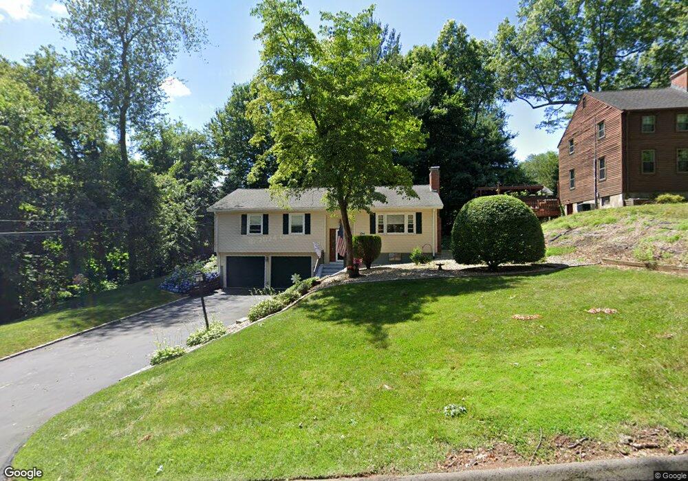
194 Rutledge Rd Wethersfield, CT 06109
Estimated Value: $376,788 - $400,000
3
Beds
2
Baths
1,236
Sq Ft
$311/Sq Ft
Est. Value
About This Home
This home is located at 194 Rutledge Rd, Wethersfield, CT 06109 and is currently estimated at $384,697, approximately $311 per square foot. 194 Rutledge Rd is a home located in Hartford County with nearby schools including Emerson-Williams School, Silas Deane Middle School, and Wethersfield High School.
Ownership History
Date
Name
Owned For
Owner Type
Purchase Details
Closed on
Dec 2, 2020
Sold by
Guay Lucille S
Bought by
Guay Gregory
Current Estimated Value
Home Financials for this Owner
Home Financials are based on the most recent Mortgage that was taken out on this home.
Original Mortgage
$156,140
Outstanding Balance
$137,668
Interest Rate
2.8%
Mortgage Type
New Conventional
Estimated Equity
$247,029
Purchase Details
Closed on
Jan 29, 1996
Sold by
Guay Henry L
Bought by
Guay Lucille S
Home Financials for this Owner
Home Financials are based on the most recent Mortgage that was taken out on this home.
Original Mortgage
$114,500
Interest Rate
7.13%
Mortgage Type
Purchase Money Mortgage
Create a Home Valuation Report for This Property
The Home Valuation Report is an in-depth analysis detailing your home's value as well as a comparison with similar homes in the area
Home Values in the Area
Average Home Value in this Area
Purchase History
| Date | Buyer | Sale Price | Title Company |
|---|---|---|---|
| Guay Gregory | $200,000 | None Available | |
| Guay Lucille S | $68,500 | -- |
Source: Public Records
Mortgage History
| Date | Status | Borrower | Loan Amount |
|---|---|---|---|
| Open | Guay Gregory | $156,140 | |
| Previous Owner | Guay Lucille S | $50,000 | |
| Previous Owner | Guay Lucille S | $160,000 | |
| Previous Owner | Guay Lucille S | $25,000 | |
| Previous Owner | Guay Lucille S | $114,500 |
Source: Public Records
Tax History
| Year | Tax Paid | Tax Assessment Tax Assessment Total Assessment is a certain percentage of the fair market value that is determined by local assessors to be the total taxable value of land and additions on the property. | Land | Improvement |
|---|---|---|---|---|
| 2025 | $8,914 | $216,250 | $70,690 | $145,560 |
| 2024 | $6,164 | $142,610 | $63,110 | $79,500 |
| 2023 | $5,958 | $142,610 | $63,110 | $79,500 |
| 2022 | $5,858 | $142,610 | $63,110 | $79,500 |
| 2021 | $5,800 | $142,610 | $63,110 | $79,500 |
| 2020 | $5,803 | $142,610 | $63,110 | $79,500 |
| 2019 | $5,810 | $142,610 | $63,110 | $79,500 |
| 2018 | $5,901 | $144,700 | $63,400 | $81,300 |
| 2017 | $5,755 | $144,700 | $63,400 | $81,300 |
| 2016 | $5,577 | $144,700 | $63,400 | $81,300 |
| 2015 | $5,526 | $144,700 | $63,400 | $81,300 |
| 2014 | $5,316 | $144,700 | $63,400 | $81,300 |
Source: Public Records
Map
Nearby Homes
- 144 Brown St
- 55 Rutledge Rd
- 20 Forest Dr
- 63 Wells Farm Dr
- 273 Forest Dr
- 295 Ridge Rd Unit 8
- 173 Timber Trail
- 764 Ridge Rd
- 129 Goff Rd
- 1 Bristol St
- 19 Albert Ave
- 1 Brussels Ave
- 15 Potter Crossing
- 62 Schoolhouse Crossing
- 25 Tinsmith Crossing
- 158 Dix Rd
- 146 Dudley Rd
- 192 Wolcott Hill Rd
- 7 Barrington Dr Unit C
- 42 Dunham St
Your Personal Tour Guide
Ask me questions while you tour the home.