


1941 S 8th St W Missoula, MT 59801
Franklin to the Fort NeighborhoodEstimated payment $1,875/month
Highlights
- Very Popular Property
- Seasonal Waterfront
- Mountain View
- Hellgate High School Rated A-
- Open Floorplan
- 1-minute walk to 8th Street Pocket Park
About This Home
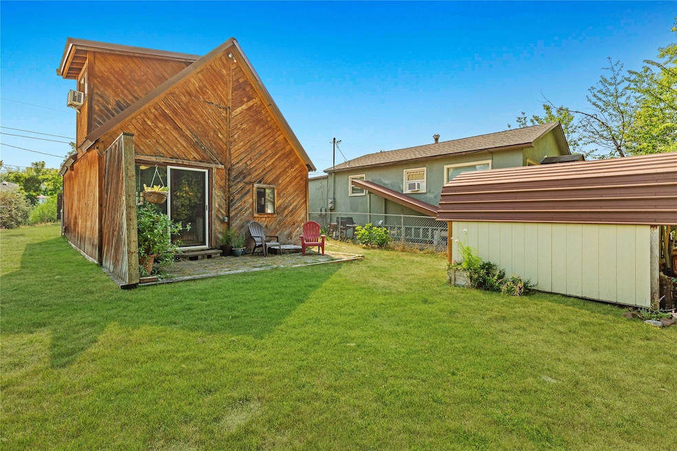
This home is quite a special offering! Tucked away on a private stretch of South 8th Street West, this one-of-a-kind Missoula residence offers an eclectic blend of rustic charm, comfort, and potential. With its ski lodge inspired design and larch wood trimmed interior and exterior, this home radiates warmth and individuality at every turn. The larch wood siding was sourced locally when the home was renovated and the stone surrounding the gas fireplace was also crafted from rocks sourced in the area. This gas fireplace anchors the living room and provides another layer of warmth and inviting Montana character. The interior of this residence provides 725 square feet of thoughtfully designed living space. In addition to a nicely sized galley kitchen, this home also offers a stand-alone dining room space as well - a unique feature for a smaller residence. A new owner may consider converting this space to an in-home office or a second bedroom on the main level. In addition to the flexibility of this lower level, you'll certainly appreciate the distinct and custom spiral wooden staircase. This unique feature leads to the lofted bedroom and private second-story deck. From here, views of Mount Dean Stone and Mount Sentinel create a stunning natural backdrop for relaxing evenings and quiet mornings. A main-level bathroom, covered carport, adjacency to the Missoula irrigation canal system, and a generous yard of nearly 5,000 square feet enhance both livability, value, and potential with this property. Perfectly situated near Benson’s Farm, Franklin Park, Grist Bakery, and the well-loved South 8th Street West micro-park, this property has a very special balance of privacy and convenience. Affordable, full of character, and brimming with potential, this residence is truly a rare find in the heart of Missoula.
Listing Agent
Berkshire Hathaway HomeServices - Missoula License #RRE-BRO-LIC-72448 Listed on: 09/10/2025

Home Details
Home Type
- Single Family
Est. Annual Taxes
- $3,495
Year Built
- Built in 1945
Lot Details
- 4,940 Sq Ft Lot
- Lot Dimensions are 35' x 130'
- Seasonal Waterfront
- Secluded Lot
- Level Lot
- Back Yard
Home Design
- A-Frame Home
- Metal Roof
- Wood Siding
Interior Spaces
- 725 Sq Ft Home
- Property has 1 Level
- Open Floorplan
- Vaulted Ceiling
- 1 Fireplace
- Mountain Views
- Basement
- Crawl Space
- Washer Hookup
Kitchen
- Oven or Range
- Stove
Bedrooms and Bathrooms
- 1 Bedroom
- 1 Bathroom
Parking
- 1 Carport Space
- Alley Access
Outdoor Features
- Balcony
- Deck
- Shed
Utilities
- Heating System Uses Gas
Listing and Financial Details
- Assessor Parcel Number 04220029170270000
Community Details
Overview
- No Home Owners Association
Recreation
- Park
Map
Home Values in the Area
Average Home Value in this Area
Tax History
| Year | Tax Paid | Tax Assessment Tax Assessment Total Assessment is a certain percentage of the fair market value that is determined by local assessors to be the total taxable value of land and additions on the property. | Land | Improvement |
|---|---|---|---|---|
| 2025 | $3,495 | $333,900 | $188,448 | $145,452 |
| 2024 | $3,587 | $275,200 | $151,814 | $123,386 |
| 2023 | $3,459 | $294,800 | $151,814 | $142,986 |
| 2022 | $2,606 | $192,500 | $0 | $0 |
| 2021 | $2,339 | $192,500 | $0 | $0 |
| 2020 | $2,214 | $168,900 | $0 | $0 |
| 2019 | $2,207 | $168,900 | $0 | $0 |
| 2018 | $1,932 | $143,800 | $0 | $0 |
| 2017 | $1,900 | $143,800 | $0 | $0 |
| 2016 | $1,743 | $137,800 | $0 | $0 |
| 2015 | $1,612 | $137,800 | $0 | $0 |
| 2014 | $1,563 | $75,207 | $0 | $0 |
Property History
| Date | Event | Price | Change | Sq Ft Price |
|---|---|---|---|---|
| 09/10/2025 09/10/25 | For Sale | $299,900 | -- | $414 / Sq Ft |
Purchase History
| Date | Type | Sale Price | Title Company |
|---|---|---|---|
| Warranty Deed | -- | Flying S Title And Escrow | |
| Warranty Deed | -- | Flying S Title And Escrow | |
| Quit Claim Deed | -- | None Available |
Mortgage History
| Date | Status | Loan Amount | Loan Type |
|---|---|---|---|
| Open | $137,546 | New Conventional | |
| Closed | $137,546 | New Conventional |
Source: Montana Regional MLS
MLS Number: 30056661
APN: 04-2200-29-1-70-27-0000
Disclaimer: Certain information contained herein is derived from information provided by parties other than Homes.com. All information provided is deemed reliable, but is not guaranteed to be accurate and should be independently verified.
![]() IDX information is provided exclusively for personal, non-commercial use, and may not be used for any purpose other than to identify prospective properties consumers may be interested in purchasing. Information is deemed reliable but not guaranteed.
IDX information is provided exclusively for personal, non-commercial use, and may not be used for any purpose other than to identify prospective properties consumers may be interested in purchasing. Information is deemed reliable but not guaranteed.
- 1935 S 8th St W
- 920 S Johnson St
- 1949 S 9th St W
- 1815 S 8th St W
- 940 Kemp St Unit A
- 2002 S 6th St W Unit 102
- 1715 S 8th St W
- 2129 S 6th St W Unit b
- 1635 S 8th St W
- 1935 S 12th St W
- 2225 S 8th St W
- 565 S Johnson St
- 1854 S 4th St W
- 2004 S 13th St W
- 2223 S 5th St W
- NHN S 13th St W Unit Lot 9A
- 1207 Linnea Ln Unit B
- 2214 S 12th St W
- 1310 Linnea Ln
- 1538 S 8th St W
- 680 S Johnson St Unit 1
- 680 S Johnson St Unit 2
- 1525 S 8th St W
- 1729 S 14th St W Unit 301
- 1910 Strand Ave Unit 201
- 1910 Strand Ave Unit 101
- 2030 Strand Ave
- 2034 Strand Ave
- 815 Marshall St
- 1580 Milwaukee Way
- 926 Cleveland St Unit . B
- 1332 River St
- 155 N California St
- 2523 W Central Ave Unit 2525
- 2075 Cooper St
- 419 S 3rd St W
- 823 Hazel St S Unit 823 1/2
- 2903 Harmony Ct
- 2907 Harmony Ct Unit 3
- 3144 S 7th St W