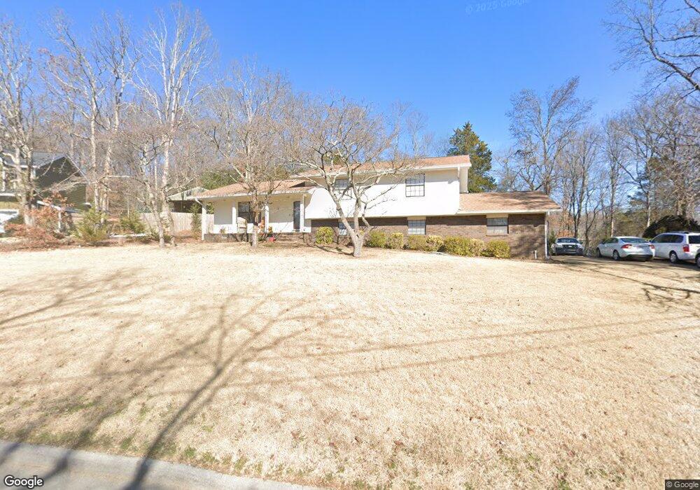
1944 Light Tower Cir Hixson, TN 37343
Estimated Value: $325,557 - $430,000
4
Beds
3
Baths
2,400
Sq Ft
$164/Sq Ft
Est. Value
About This Home
This home is located at 1944 Light Tower Cir, Hixson, TN 37343 and is currently estimated at $393,389, approximately $163 per square foot. 1944 Light Tower Cir is a home located in Hamilton County with nearby schools including McConnell Elementary School, Loftis Middle School, and Hixson High School.
Ownership History
Date
Name
Owned For
Owner Type
Purchase Details
Closed on
Mar 8, 1999
Sold by
Carter Scott C and Carter Lori C
Bought by
Cooksey W Rodger and Cooksey Beverly K
Current Estimated Value
Home Financials for this Owner
Home Financials are based on the most recent Mortgage that was taken out on this home.
Original Mortgage
$103,200
Outstanding Balance
$25,062
Interest Rate
6.79%
Estimated Equity
$368,327
Purchase Details
Closed on
Jun 12, 1995
Sold by
Collins George F and Collins Tina H
Bought by
Carter Scott C and Carter Lori C
Create a Home Valuation Report for This Property
The Home Valuation Report is an in-depth analysis detailing your home's value as well as a comparison with similar homes in the area
Home Values in the Area
Average Home Value in this Area
Purchase History
| Date | Buyer | Sale Price | Title Company |
|---|---|---|---|
| Cooksey W Rodger | $129,000 | -- | |
| Carter Scott C | $110,000 | -- |
Source: Public Records
Mortgage History
| Date | Status | Borrower | Loan Amount |
|---|---|---|---|
| Open | Cooksey W Rodger | $103,200 |
Source: Public Records
Tax History Compared to Growth
Tax History
| Year | Tax Paid | Tax Assessment Tax Assessment Total Assessment is a certain percentage of the fair market value that is determined by local assessors to be the total taxable value of land and additions on the property. | Land | Improvement |
|---|---|---|---|---|
| 2024 | $1,196 | $53,475 | $0 | $0 |
| 2023 | $1,205 | $53,475 | $0 | $0 |
| 2022 | $1,205 | $53,475 | $0 | $0 |
| 2021 | $1,205 | $53,475 | $0 | $0 |
| 2020 | $1,187 | $42,600 | $0 | $0 |
| 2019 | $1,187 | $42,600 | $0 | $0 |
| 2018 | $1,187 | $42,600 | $0 | $0 |
| 2017 | $1,187 | $42,600 | $0 | $0 |
| 2016 | $1,093 | $0 | $0 | $0 |
| 2015 | $1,093 | $39,200 | $0 | $0 |
| 2014 | $1,093 | $0 | $0 | $0 |
Source: Public Records
Map
Nearby Homes
- 1705 Sea Gull Ln
- 1924 Bay Pointe Dr
- 6512 Fairview Rd
- 1800 Mountain Bay Dr
- 1820 Rock Bluff Rd
- 2227 Bay Pointe Dr
- 1706 Mountain Bay Dr
- 1657 Destiny Dr
- 000 Hixson Pike
- 1689 Destiny Dr
- 1681 Destiny Dr
- 1693 Destiny Dr
- 6424 Serenade Ln
- 6517 Shelter Cove Dr
- 6577 Fairview Rd
- Piedmont Plan at Nestledown
- Altamont Plan at Nestledown
- Blue Ridge Plan at Nestledown
- 6453 Serenade Ln
- 7400 Hixson Pike
- 1942 Light Tower Cir Unit 13
- 1948 Light Tower Cir
- 6424 Lake Meadows Dr
- 1943 Light Tower Cir
- 1940 Light Tower Cir
- 6420 Lake Meadows Dr
- 6426 Lake Meadows Dr
- 1949 Light Tower Cir Unit 13
- 1949 Light Tower Cir Unit 1333
- 1938 Light Tower Cir
- 1938 Light Tower Cir Unit 1333
- 6416 Lake Meadows Dr
- 1935 Light Tower Cir
- 6400 Lighthouse Ln
- 6400 Lighthouse Ln Unit 1333
- 6404 Lighthouse Ln
- 6432 Lake Meadows Dr Unit 1
- 6425 Lake Meadows Dr
- 6425 Lake Meadows Dr Unit LOT 16
- 1901 Light Tower Cir