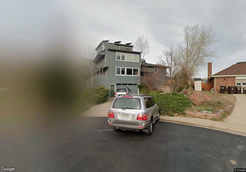
1945 Vassar Cir Boulder, CO 80305
Table Mesa NeighborhoodEstimated Value: $2,702,000 - $4,183,000
7
Beds
5
Baths
5,021
Sq Ft
$700/Sq Ft
Est. Value
About This Home
This home is located at 1945 Vassar Cir, Boulder, CO 80305 and is currently estimated at $3,515,807, approximately $700 per square foot. 1945 Vassar Cir is a home located in Boulder County with nearby schools including Bear Creek Elementary School, Southern Hills Middle School, and Fairview High School.
Ownership History
Date
Name
Owned For
Owner Type
Purchase Details
Closed on
Nov 30, 2000
Sold by
Havlick Stanley E and Havlick Marilyn K
Bought by
Wurman Josh
Current Estimated Value
Home Financials for this Owner
Home Financials are based on the most recent Mortgage that was taken out on this home.
Original Mortgage
$500,000
Outstanding Balance
$186,111
Interest Rate
7.84%
Estimated Equity
$3,329,696
Purchase Details
Closed on
Jun 30, 1976
Bought by
Chan Wurman Josh and Chan Ling
Create a Home Valuation Report for This Property
The Home Valuation Report is an in-depth analysis detailing your home's value as well as a comparison with similar homes in the area
Home Values in the Area
Average Home Value in this Area
Purchase History
| Date | Buyer | Sale Price | Title Company |
|---|---|---|---|
| Wurman Josh | $910,000 | -- | |
| Chan Wurman Josh | $26,500 | -- |
Source: Public Records
Mortgage History
| Date | Status | Borrower | Loan Amount |
|---|---|---|---|
| Open | Wurman Josh | $500,000 | |
| Closed | Wurman Josh | $228,000 |
Source: Public Records
Tax History Compared to Growth
Tax History
| Year | Tax Paid | Tax Assessment Tax Assessment Total Assessment is a certain percentage of the fair market value that is determined by local assessors to be the total taxable value of land and additions on the property. | Land | Improvement |
|---|---|---|---|---|
| 2025 | $21,717 | $201,237 | $89,331 | $111,906 |
| 2024 | $21,717 | $201,237 | $89,331 | $111,906 |
| 2023 | $21,340 | $247,109 | $106,972 | $143,822 |
| 2022 | $16,975 | $182,792 | $78,229 | $104,563 |
| 2021 | $16,187 | $188,052 | $80,480 | $107,572 |
| 2020 | $15,066 | $173,080 | $93,665 | $79,415 |
| 2019 | $14,835 | $173,080 | $93,665 | $79,415 |
| 2018 | $14,039 | $161,928 | $66,672 | $95,256 |
| 2017 | $13,600 | $179,021 | $73,710 | $105,311 |
| 2016 | $12,231 | $141,290 | $81,590 | $59,700 |
| 2015 | $11,582 | $129,612 | $65,431 | $64,181 |
| 2014 | $10,898 | $129,612 | $65,431 | $64,181 |
Source: Public Records
Map
Nearby Homes
- 2100 Kohler Dr
- 2235 Vassar Dr
- 1965 Kohler Dr
- 1865 Kohler Dr
- 2490 Vassar Dr
- 2585 Kohler Dr
- 2955 Stanford Ave
- 2880 La Grange Cir
- 140 S Lashley Ln
- 1120 Hartford Dr
- 45 Bellevue Dr
- 1265 Hartford Dr
- 245 Fair Place
- 75 Bellevue Dr
- 1505 Kendall Dr
- 2250 Bluebell Ave
- 2464 Powderhorn Ln
- 325 27th St
- 1498 King Ave
- 2003 Bluebell Ave
- 1955 Vassar Cir
- 1935 Vassar Dr
- 1935 Vassar Cir
- 1965 Vassar Cir
- 1925 Vassar Dr
- 1985 Vassar Cir
- 1905 Vassar Dr
- 2005 Vassar Dr
- 2060 Kohler Dr
- 2040 Kohler Dr
- 1960 Vassar Dr
- 1930 Vassar Dr
- 2035 Vassar Dr
- 1990 Vassar Dr
- 1910 Vassar Dr
- 2140 Kohler Dr
- 2010 Vassar Dr
- 2065 Vassar Dr
- 2030 Vassar Dr
- 2020 Kohler Dr