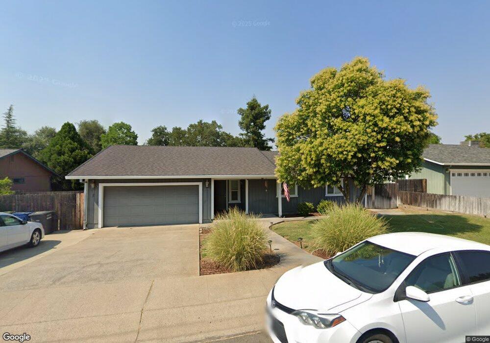
1958 S Ridge Dr Redding, CA 96003
Lema Ranch NeighborhoodEstimated Value: $406,000 - $571,000
3
Beds
2
Baths
1,470
Sq Ft
$326/Sq Ft
Est. Value
About This Home
This home is located at 1958 S Ridge Dr, Redding, CA 96003 and is currently estimated at $479,705, approximately $326 per square foot. 1958 S Ridge Dr is a home located in Shasta County with nearby schools including Mistletoe Elementary School, Foothill High School, and Redding School Of The Arts.
Ownership History
Date
Name
Owned For
Owner Type
Purchase Details
Closed on
Jul 1, 2002
Sold by
Morphew Frankie Catherin and Morphew Kenneth Ray
Bought by
Morphew Frankie Catherin and Morphew Kenneth Ray
Current Estimated Value
Purchase Details
Closed on
Jun 5, 2002
Sold by
Avery Ollie T
Bought by
Morphew Frankie Catherin and Morphew Kenneth Ray
Purchase Details
Closed on
Dec 15, 1997
Sold by
Avery and Ollie
Bought by
Avery Rufus and Avery Ollie T
Create a Home Valuation Report for This Property
The Home Valuation Report is an in-depth analysis detailing your home's value as well as a comparison with similar homes in the area
Home Values in the Area
Average Home Value in this Area
Purchase History
| Date | Buyer | Sale Price | Title Company |
|---|---|---|---|
| Morphew Frankie Catherin | -- | -- | |
| Morphew Frankie Catherin | -- | -- | |
| Avery Rufus | -- | -- |
Source: Public Records
Tax History Compared to Growth
Tax History
| Year | Tax Paid | Tax Assessment Tax Assessment Total Assessment is a certain percentage of the fair market value that is determined by local assessors to be the total taxable value of land and additions on the property. | Land | Improvement |
|---|---|---|---|---|
| 2025 | $2,072 | $202,489 | $15,343 | $187,146 |
| 2024 | $2,038 | $198,520 | $15,043 | $183,477 |
| 2023 | $2,038 | $194,629 | $14,749 | $179,880 |
| 2022 | $1,983 | $190,813 | $14,460 | $176,353 |
| 2021 | $1,965 | $187,073 | $14,177 | $172,896 |
| 2020 | $1,944 | $185,156 | $14,032 | $171,124 |
| 2019 | $1,891 | $181,526 | $13,757 | $167,769 |
| 2018 | $1,896 | $177,968 | $13,488 | $164,480 |
| 2017 | $1,873 | $174,479 | $13,224 | $161,255 |
| 2016 | $1,768 | $171,059 | $12,965 | $158,094 |
| 2015 | $1,742 | $168,491 | $12,771 | $155,720 |
| 2014 | -- | $165,191 | $12,521 | $152,670 |
Source: Public Records
Map
Nearby Homes
- 1090 Gibralter Rd
- 1285 Lancers Ln
- 1088 Burton Dr
- 874 Spaniel Dr
- 2517 Atrium Way
- 1261 Woodside Meadows Dr
- 774 Springer Dr
- 866 Fountain Cir
- 1939 Cameo Ct
- 550 Armando Ave
- 2022 Tarmac Rd
- 2093 Victor Ave
- 667 Reddington Dr
- 2030 Hedgerow Ave
- 1610 Oakdale Ct
- 2293 Milano Trail
- 790 Volcano View Trail
- 1945 Salzburg Trail
- 1271 Mistletoe Ln
- 332 Franciscan Trail
- 1958 S Ridge Dr
- 1936 S Ridge Dr
- 981 Oakmont Dr
- 995 Oakmont Dr
- 1998 S Ridge Dr
- 967 Oakmont Dr
- 1915 S Ridge Dr
- 1922 S Ridge Dr
- 1951 S Ridge Dr
- 1070 Oakmont Dr
- 953 Oakmont Dr
- 1973 S Ridge Dr
- 1995 S Ridge Dr
- 939 Oakmont Dr Unit 1
- 939 Oakmont Dr
- 1109 Belcrest Dr
- 1117 Belcrest Dr
- 986 Oakmont Dr
- 1125 Belcrest Dr
- 974 Oakmont Dr