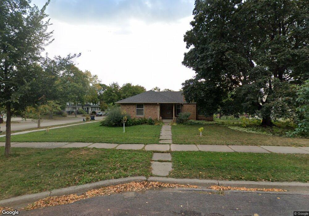
1959 Stinson Blvd Minneapolis, MN 55418
Windom Park NeighborhoodEstimated Value: $402,000 - $518,000
2
Beds
2
Baths
1,335
Sq Ft
$340/Sq Ft
Est. Value
About This Home
This home is located at 1959 Stinson Blvd, Minneapolis, MN 55418 and is currently estimated at $454,325, approximately $340 per square foot. 1959 Stinson Blvd is a home located in Hennepin County with nearby schools including Pillsbury Elementary School, Northeast Middle School, and Thomas Edison High School.
Ownership History
Date
Name
Owned For
Owner Type
Purchase Details
Closed on
Aug 26, 2021
Sold by
Hixson Mary Emma and Salas Catalina
Bought by
Hartig Daniel D and Hartig Darray C
Current Estimated Value
Home Financials for this Owner
Home Financials are based on the most recent Mortgage that was taken out on this home.
Original Mortgage
$200,000
Interest Rate
2.8%
Mortgage Type
New Conventional
Purchase Details
Closed on
Sep 15, 2004
Sold by
Lundblad Alice C
Bought by
Hixson Mary Emma and Salas Catalina
Create a Home Valuation Report for This Property
The Home Valuation Report is an in-depth analysis detailing your home's value as well as a comparison with similar homes in the area
Home Values in the Area
Average Home Value in this Area
Purchase History
| Date | Buyer | Sale Price | Title Company |
|---|---|---|---|
| Hartig Daniel D | $355,000 | Titlesmart Inc | |
| Hixson Mary Emma | $304,500 | -- | |
| Hartig Daniel Daniel | $355,000 | -- |
Source: Public Records
Mortgage History
| Date | Status | Borrower | Loan Amount |
|---|---|---|---|
| Previous Owner | Hartig Daniel D | $200,000 | |
| Closed | Hartig Daniel Daniel | $192,452 |
Source: Public Records
Tax History Compared to Growth
Tax History
| Year | Tax Paid | Tax Assessment Tax Assessment Total Assessment is a certain percentage of the fair market value that is determined by local assessors to be the total taxable value of land and additions on the property. | Land | Improvement |
|---|---|---|---|---|
| 2024 | $6,455 | $434,000 | $158,000 | $276,000 |
| 2023 | $5,443 | $417,000 | $143,000 | $274,000 |
| 2022 | $5,723 | $397,000 | $122,000 | $275,000 |
| 2021 | $4,982 | $413,000 | $102,000 | $311,000 |
| 2020 | $5,282 | $375,500 | $119,300 | $256,200 |
| 2019 | $5,441 | $368,000 | $97,400 | $270,600 |
| 2018 | $4,979 | $368,000 | $97,400 | $270,600 |
| 2017 | $4,707 | $313,500 | $88,500 | $225,000 |
| 2016 | $4,442 | $289,000 | $88,500 | $200,500 |
| 2015 | $3,990 | $251,500 | $88,500 | $163,000 |
| 2014 | -- | $218,500 | $78,000 | $140,500 |
Source: Public Records
Map
Nearby Homes
- 1938 Mckinley St NE
- 1802 Mckinley St NE
- 2354 Mckinley St NE
- 2307 Harding St NE
- 2358 Benjamin St NE
- 2546 Mckinley St NE
- 1937 Hayes St NE
- 2559 Mckinley St NE
- 1921 Hayes St NE
- 2501 NE Lowry Ave Unit 228
- 2501 NE Lowry Ave Unit 201
- 1711 22nd Ave NE
- 2422 Garfield St NE
- 2538 Garfield St NE
- 2601 Kenzie Terrace Unit 103
- 2601 Kenzie Terrace Unit 511
- 2601 Kenzie Terrace Unit 324
- 2601 Kenzie Terrace Unit 412
- 2601 Kenzie Terrace Unit 329
- 2601 Kenzie Terrace Unit 519
- 1951 Stinson Blvd
- 2416 22nd Ave NE
- 1947 Stinson Blvd
- 2201 NE Stinson Pkwy Unit N
- 2201 Stinson Blvd
- 2420 22nd Ave NE
- 1941 Stinson Blvd Unit N
- 1941 Stinson Blvd
- 2200 Roosevelt St NE
- 2207 Stinson Blvd
- 2500 22nd Ave NE
- 2206 Roosevelt St NE
- 1935 Stinson Blvd
- 1935 Stinson Blvd Unit N
- 1935 Stinson Blvd
- 1958 Stinson Blvd
- 1950 Stinson Blvd
- 2211 Stinson Blvd
- 2211 NE Stinson Pkwy
- 1946 Stinson Blvd