Estimated Value: $233,000 - $340,000
2
Beds
1
Bath
952
Sq Ft
$290/Sq Ft
Est. Value
About This Home
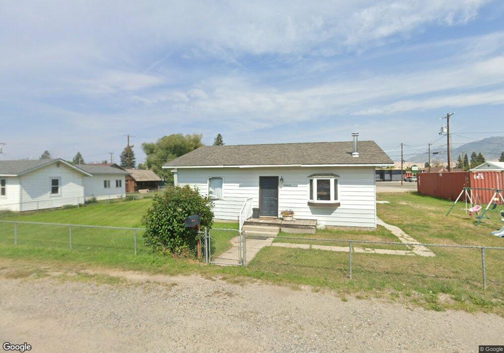
This home is located at 1963 Princeton St, Butte, MT 59701 and is currently estimated at $275,845, approximately $289 per square foot. 1963 Princeton St is a home located in Silver Bow County with nearby schools including Emerson School, East Middle School, and Butte High School.
Ownership History
Date
Name
Owned For
Owner Type
Purchase Details
Closed on
Aug 17, 2018
Sold by
Vadnais Blake F
Bought by
Stringer Shonda L
Current Estimated Value
Home Financials for this Owner
Home Financials are based on the most recent Mortgage that was taken out on this home.
Original Mortgage
$126,100
Outstanding Balance
$109,513
Interest Rate
4.5%
Mortgage Type
New Conventional
Estimated Equity
$166,332
Purchase Details
Closed on
May 30, 2014
Sold by
Whitehead Jay Tanner and Whitehead Cydney Ann
Bought by
Vadnais Blake F
Purchase Details
Closed on
Jun 1, 2011
Sold by
Whitehead Debra L
Bought by
Whitehead Debra L and Whitehead Jay Tanner
Purchase Details
Closed on
Feb 7, 2011
Sold by
Whitehead Debra L
Bought by
Whitehead Debra L and Bisch John Patrick
Purchase Details
Closed on
May 27, 2010
Sold by
Bisch Ted W and Bisch Honora G
Bought by
Whitehead Debra L
Create a Home Valuation Report for This Property
The Home Valuation Report is an in-depth analysis detailing your home's value as well as a comparison with similar homes in the area
Home Values in the Area
Average Home Value in this Area
Purchase History
| Date | Buyer | Sale Price | Title Company |
|---|---|---|---|
| Stringer Shonda L | -- | None Available | |
| Vadnais Blake F | -- | None Available | |
| Whitehead Debra L | -- | -- | |
| Whitehead Debra L | -- | -- | |
| Whitehead Debra L | -- | -- |
Source: Public Records
Mortgage History
| Date | Status | Borrower | Loan Amount |
|---|---|---|---|
| Open | Stringer Shonda L | $126,100 |
Source: Public Records
Tax History Compared to Growth
Tax History
| Year | Tax Paid | Tax Assessment Tax Assessment Total Assessment is a certain percentage of the fair market value that is determined by local assessors to be the total taxable value of land and additions on the property. | Land | Improvement |
|---|---|---|---|---|
| 2025 | $1,999 | $243,600 | $0 | $0 |
| 2024 | $2,143 | $180,200 | $0 | $0 |
| 2023 | $2,135 | $180,200 | $0 | $0 |
| 2022 | $2,041 | $134,200 | $0 | $0 |
| 2021 | $1,487 | $134,200 | $0 | $0 |
| 2020 | $2,104 | $131,000 | $0 | $0 |
| 2019 | $2,099 | $131,000 | $0 | $0 |
| 2018 | $1,961 | $123,300 | $0 | $0 |
| 2017 | $1,251 | $123,300 | $0 | $0 |
| 2016 | $1,547 | $95,900 | $0 | $0 |
| 2015 | $1,012 | $95,900 | $0 | $0 |
| 2014 | $1,213 | $36,464 | $0 | $0 |
Source: Public Records
Map
Nearby Homes
- 1806 C St
- 1801 Yale Ave
- 2263 West Dr
- 2212 Massachusetts Ave
- 1727 A St
- 2125 Garrison Ave
- 2245 South Dr
- 2219 Amherst Ave
- 2007 Florida Ave
- 2319 Princeton St
- 2000 Florida Ave
- 2320 South Dr
- 1663 Schley Ave
- 1863 Dewey Blvd
- 1636 Schley Ave
- 1408 C St
- 1648 Dewey Blvd
- 1875 Harrison Ave
- 1851 Massachusetts Ave
- 1824 Massachusetts Ave
- 1959 Princeton St
- 1967 Princeton St
- 1937 Princeton St
- 1916 C St
- 2407 Harrison Ave
- 1958 Princeton St
- 1925 Princeton St
- 1968 Princeton St
- 1952 Princeton St
- 1914 C St
- 1972 Princeton St
- 1921 Princeton St
- 1912 C St
- 1967 Yale Ave
- 1937 Yale Ave
- 1950 Princeton St
- 1911 Princeton St
- 1933 Yale Ave
- 1910 C St
- 1931 Yale Ave