
Seller's Agent in 2021
Jeffrey Johnson
Windermere Van Vleet & Assoc2
(541) 779-6520
134 Total Sales


Estimated Value: $350,857
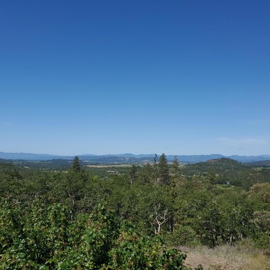
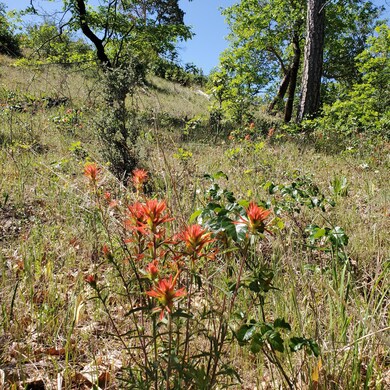
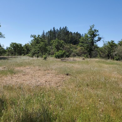
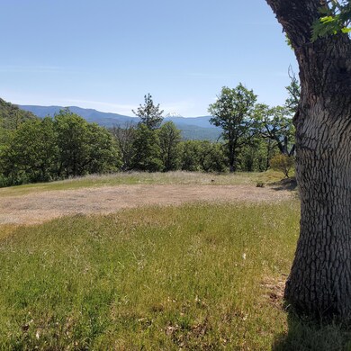
The Oregon Dream - a private parcel of land on 7.20 beautiful view acres! Well and four bedroom septic installed, power to the property, and incredible view pad already cut for your new home. This parcel offers complete privacy, unobstructed views of Mt. McLoughlin, abundant wildlife, and backs to BLM property. You will be so amazed at the possibilities for this property. Per county, this section of Worthington Road is scheduled for paving by the end of July at not cost to property owners. Approximately 10 minutes away from charming Eagle Point and a short commute to Medford. Truly a great Oregon Dream property! All information is provided in good faith and is believed to be true and accurate. No warranty or representation, express or implied, is made as to the accuracy of the information provided; all information contained herein is subject to change, errors, and omission and is subject to buyer's independent verification.
Last Agent to Sell the Property
Windermere Van Vleet & Assoc2 License #200402091 Listed on: 05/10/2021
| Date | Buyer | Sale Price | Title Company |
|---|---|---|---|
| Laemmlein Michael | $325,000 | First American | |
| Banks Sandia P | -- | Lawyers Title Ins | |
| Building Exchange Co | $272,500 | Lawyers Title Ins |
| Date | Status | Borrower | Loan Amount |
|---|---|---|---|
| Previous Owner | Building Exchange Co | $272,500 |
| Date | Event | Price | List to Sale | Price per Sq Ft |
|---|---|---|---|---|
| 05/28/2021 05/28/21 | Sold | $325,000 | -3.0% | $282 / Sq Ft |
| 05/15/2021 05/15/21 | Pending | -- | -- | -- |
| 05/10/2021 05/10/21 | For Sale | $335,000 | -- | $291 / Sq Ft |
| Year | Tax Paid | Tax Assessment Tax Assessment Total Assessment is a certain percentage of the fair market value that is determined by local assessors to be the total taxable value of land and additions on the property. | Land | Improvement |
|---|---|---|---|---|
| 2026 | $1,399 | $167,100 | -- | -- |
| 2025 | $1,368 | $162,240 | $162,240 | -- |
| 2024 | $1,368 | $157,520 | $157,520 | -- |
| 2023 | $1,320 | $152,940 | $152,940 | $0 |
| 2022 | $1,280 | $152,940 | $152,940 | $0 |
| 2021 | $1,239 | $148,490 | $148,490 | $0 |
| 2020 | $1,389 | $144,170 | $144,170 | $0 |
| 2019 | $1,379 | $135,910 | $135,910 | $0 |
| 2018 | $2,185 | $164,030 | $73,580 | $90,450 |
| 2017 | $2,133 | $164,030 | $73,580 | $90,450 |
| 2016 | $2,079 | $154,630 | $69,360 | $85,270 |
| 2015 | $2,009 | $154,630 | $69,360 | $85,270 |
| 2014 | -- | $145,760 | $65,380 | $80,380 |
Seller's Agent in 2021
Jeffrey Johnson
Windermere Van Vleet & Assoc2
(541) 779-6520
134 Total Sales
Buyer's Agent in 2021
Ron Burgess
RE/MAX
(541) 301-4781
3 Total Sales
Source: Oregon Datashare
MLS Number: 220122279
APN: 10709110
Disclaimer: Certain information contained herein is derived from information provided by parties other than Homes.com. All information provided is deemed reliable, but is not guaranteed to be accurate and should be independently verified.
![]() © 2026 Oregon Datashare (KCAR | MLSCO | SOMLS). All rights reserved. The data relating to real estate for sale on this web site comes in part from the Internet Data Exchange Program of the Oregon Datashare. Real estate listings held by IDX Brokerage firms other than Ten-X are marked with the Internet Data Exchange logo or the Internet Data Exchange thumbnail logo and detailed information about them includes the name of the listing Brokers. Information provided is for consumers' personal, non-commercial use and may not be used for any purpose other than to identify prospective properties the viewer may be interested in purchasing. The consumer will not copy, retransmit nor redistribute any of the content from this website. Information provided is deemed reliable, but not guaranteed.
© 2026 Oregon Datashare (KCAR | MLSCO | SOMLS). All rights reserved. The data relating to real estate for sale on this web site comes in part from the Internet Data Exchange Program of the Oregon Datashare. Real estate listings held by IDX Brokerage firms other than Ten-X are marked with the Internet Data Exchange logo or the Internet Data Exchange thumbnail logo and detailed information about them includes the name of the listing Brokers. Information provided is for consumers' personal, non-commercial use and may not be used for any purpose other than to identify prospective properties the viewer may be interested in purchasing. The consumer will not copy, retransmit nor redistribute any of the content from this website. Information provided is deemed reliable, but not guaranteed.
Ask me questions while you tour the home.