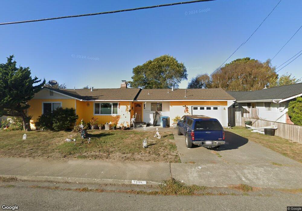
1969 Upper Bay Rd Arcata, CA 95521
Estimated Value: $275,000 - $430,000
3
Beds
2
Baths
1,100
Sq Ft
$344/Sq Ft
Est. Value
About This Home
This home is located at 1969 Upper Bay Rd, Arcata, CA 95521 and is currently estimated at $378,092, approximately $343 per square foot. 1969 Upper Bay Rd is a home located in Humboldt County with nearby schools including Pacific Union Elementary School, Arcata High School, and Trillium Charter School.
Ownership History
Date
Name
Owned For
Owner Type
Purchase Details
Closed on
Sep 2, 2011
Sold by
Caldwell Geoffrey and Caldwell Mary
Bought by
Caldwell Geoffrey and Caldwell Mary
Current Estimated Value
Purchase Details
Closed on
Jul 13, 1998
Sold by
Odell Tharon E and Odell Sandra L
Bought by
Caldwell Geoffrey and Caldwell Mary
Create a Home Valuation Report for This Property
The Home Valuation Report is an in-depth analysis detailing your home's value as well as a comparison with similar homes in the area
Purchase History
| Date | Buyer | Sale Price | Title Company |
|---|---|---|---|
| Caldwell Geoffrey | -- | None Available | |
| Caldwell Geoffrey | $111,500 | Humboldt Land Title Co |
Source: Public Records
Tax History
| Year | Tax Paid | Tax Assessment Tax Assessment Total Assessment is a certain percentage of the fair market value that is determined by local assessors to be the total taxable value of land and additions on the property. | Land | Improvement |
|---|---|---|---|---|
| 2025 | $1,995 | $174,777 | $76,806 | $97,971 |
| 2024 | $1,995 | $171,350 | $75,300 | $96,050 |
| 2023 | $1,995 | $167,991 | $73,824 | $94,167 |
| 2022 | $1,985 | $164,698 | $72,377 | $92,321 |
| 2021 | $1,974 | $161,469 | $70,958 | $90,511 |
| 2020 | $1,869 | $159,814 | $70,231 | $89,583 |
| 2019 | $1,841 | $156,681 | $68,854 | $87,827 |
| 2018 | $1,724 | $153,609 | $67,504 | $86,105 |
| 2017 | $1,698 | $150,598 | $66,181 | $84,417 |
| 2016 | $1,670 | $147,646 | $64,884 | $82,762 |
| 2015 | $1,641 | $145,429 | $63,910 | $81,519 |
| 2014 | $1,618 | $142,582 | $62,659 | $79,923 |
Source: Public Records
Map
Nearby Homes
- 3106 Brian Ct
- 3659 Spear Ave
- 2203 Appaloosa Ln
- 3301 Antoinette Ct
- 2084 Mustang Ln
- 3735 Shetland Ln
- 2048 Appaloosa Ln
- 2078 Shetland Ln
- 3030 Alliance Rd
- 1254 Mccallum Cir
- 3028 Alliance Rd
- 1666 Stewart Ave
- 3122 St Louis Rd
- 2700 Meadow Creek Way
- 1283 Poplar Dr
- 1082 Cedar Dr
- 4965 Monterey Dr
- 00 Mad River Pkwy
- 812 Diamond Dr
- 970 Courtyard Cir
- 1975 Upper Bay Rd
- 1963 Upper Bay Rd
- 1970 Leslie Ct
- 1972 Leslie Ct
- 1981 Upper Bay Rd
- 1978 Leslie Ct
- 3018 Janes Rd
- 3026 Janes Rd
- 1984 Leslie Ct
- 1987 Upper Bay Rd
- 3032 Janes Rd
- 1973 Leslie Ct
- 1988 Leslie Ct
- 3048 Janes Rd
- 1993 Upper Bay Rd
- 1975 Leslie Ct
- 1977 Leslie Ct
- 1985 Leslie Ct
- 1994 Leslie Ct
- 3062 Janes Rd
Your Personal Tour Guide
Ask me questions while you tour the home.