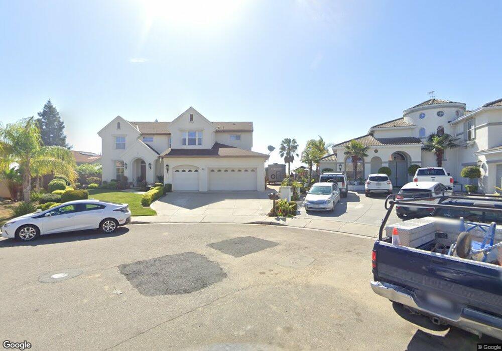
1970 Windy Peak Ct Antioch, CA 94531
Lone Tree Valley NeighborhoodEstimated Value: $915,000 - $979,000
5
Beds
5
Baths
4,005
Sq Ft
$237/Sq Ft
Est. Value
About This Home
This home is located at 1970 Windy Peak Ct, Antioch, CA 94531 and is currently estimated at $951,096, approximately $237 per square foot. 1970 Windy Peak Ct is a home located in Contra Costa County with nearby schools including Lone Tree Elementary School, Dallas Ranch Middle School, and Deer Valley High School.
Ownership History
Date
Name
Owned For
Owner Type
Purchase Details
Closed on
Jan 13, 2004
Sold by
Black Diamond Knolls Ltd
Bought by
Fiutek Andrzej B and Fiutek Halina
Current Estimated Value
Home Financials for this Owner
Home Financials are based on the most recent Mortgage that was taken out on this home.
Original Mortgage
$400,000
Outstanding Balance
$167,039
Interest Rate
4.37%
Mortgage Type
Purchase Money Mortgage
Estimated Equity
$784,057
Create a Home Valuation Report for This Property
The Home Valuation Report is an in-depth analysis detailing your home's value as well as a comparison with similar homes in the area
Home Values in the Area
Average Home Value in this Area
Purchase History
| Date | Buyer | Sale Price | Title Company |
|---|---|---|---|
| Fiutek Andrzej B | $624,000 | Old Republic Title |
Source: Public Records
Mortgage History
| Date | Status | Borrower | Loan Amount |
|---|---|---|---|
| Open | Fiutek Andrzej B | $400,000 |
Source: Public Records
Tax History Compared to Growth
Tax History
| Year | Tax Paid | Tax Assessment Tax Assessment Total Assessment is a certain percentage of the fair market value that is determined by local assessors to be the total taxable value of land and additions on the property. | Land | Improvement |
|---|---|---|---|---|
| 2025 | $9,851 | $890,024 | $272,974 | $617,050 |
| 2024 | $9,504 | $872,573 | $267,622 | $604,951 |
| 2023 | $9,504 | $855,465 | $262,375 | $593,090 |
| 2022 | $9,350 | $838,692 | $257,231 | $581,461 |
| 2021 | $8,067 | $724,000 | $222,055 | $501,945 |
| 2019 | $7,342 | $648,000 | $198,746 | $449,254 |
| 2018 | $7,105 | $639,000 | $195,985 | $443,015 |
| 2017 | $6,456 | $576,500 | $176,816 | $399,684 |
| 2016 | $6,092 | $543,500 | $166,695 | $376,805 |
| 2015 | $6,007 | $499,500 | $153,200 | $346,300 |
| 2014 | $6,963 | $486,500 | $149,213 | $337,287 |
Source: Public Records
Map
Nearby Homes
- 5488 Southwood Ct
- 1914 Table Mountain Way
- 5448 Southwood Way
- 1838 Buck Mountain Ct
- 1333 Mokelumne Dr
- 1856 Buck Mountain Ct
- 1787 Sanger Peak Way
- 1821 Kern Mountain Way
- 5243 Delta View Way
- 2401 Silveria Way
- 1256 Mokelumne Ct
- 4679 Rivertown Place
- 4604 Coal Hill Place
- 1153 Stonecrest Dr
- 1071 Stonecrest Dr
- 2344 Forty Niner Ct
- 2498 Taylor Way
- 2510 Vallecito Way
- 1928 Badger Pass Way
- 2721 Vallejo Ct
- 1971 Windy Peak Ct
- 1968 Mount Henry Ct
- 1968 Windy Peak Ct
- 1966 Mount Henry Ct
- 1966 Windy Peak Ct
- 1969 Windy Peak Ct
- 1970 Mount Henry Ct
- 1964 Mount Henry Ct
- 1967 Windy Peak Ct
- 1964 Windy Peak Ct
- 1965 Windy Peak Ct
- 1962 Mount Henry Ct
- 1863 Table Mountain Ct
- 1972 Mount Henry Ct
- 1865 Table Mountain Ct
- 1963 Windy Peak Ct
- 1974 Mount Henry Ct
- 1962 Windy Peak Ct
- 1976 Mount Henry Ct
- 1960 Mount Henry Ct