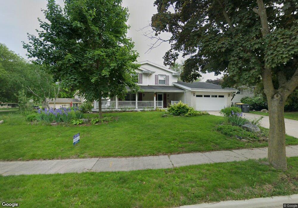
1977 Sunnyside Dr Waukesha, WI 53186
Estimated Value: $381,000 - $431,000
4
Beds
2
Baths
1,836
Sq Ft
$222/Sq Ft
Est. Value
About This Home
This home is located at 1977 Sunnyside Dr, Waukesha, WI 53186 and is currently estimated at $407,677, approximately $222 per square foot. 1977 Sunnyside Dr is a home located in Waukesha County with nearby schools including John F. Miller School, Banting Elementary School, and Horning Middle School.
Ownership History
Date
Name
Owned For
Owner Type
Purchase Details
Closed on
Jan 13, 2017
Sold by
Brackmann Richard C and Brackmann Pamela J
Bought by
Sajdak Jannie L
Current Estimated Value
Home Financials for this Owner
Home Financials are based on the most recent Mortgage that was taken out on this home.
Original Mortgage
$167,200
Outstanding Balance
$138,490
Interest Rate
4.3%
Mortgage Type
New Conventional
Estimated Equity
$269,187
Purchase Details
Closed on
May 6, 1996
Sold by
Mernaugh Raymond L and Mernaugh Glenda R
Bought by
Brackmann Richard C and Brackmann Pamela J
Home Financials for this Owner
Home Financials are based on the most recent Mortgage that was taken out on this home.
Original Mortgage
$110,000
Interest Rate
6.9%
Create a Home Valuation Report for This Property
The Home Valuation Report is an in-depth analysis detailing your home's value as well as a comparison with similar homes in the area
Home Values in the Area
Average Home Value in this Area
Purchase History
| Date | Buyer | Sale Price | Title Company |
|---|---|---|---|
| Sajdak Jannie L | $209,000 | None Available | |
| Brackmann Richard C | $150,000 | -- |
Source: Public Records
Mortgage History
| Date | Status | Borrower | Loan Amount |
|---|---|---|---|
| Open | Sajdak Jannie L | $167,200 | |
| Previous Owner | Brackmann Richard C | $110,000 |
Source: Public Records
Tax History Compared to Growth
Tax History
| Year | Tax Paid | Tax Assessment Tax Assessment Total Assessment is a certain percentage of the fair market value that is determined by local assessors to be the total taxable value of land and additions on the property. | Land | Improvement |
|---|---|---|---|---|
| 2024 | $4,766 | $321,700 | $68,000 | $253,700 |
| 2023 | $4,632 | $321,700 | $68,000 | $253,700 |
| 2022 | $4,443 | $232,200 | $64,600 | $167,600 |
| 2021 | $4,546 | $232,200 | $64,600 | $167,600 |
| 2020 | $4,394 | $232,200 | $64,600 | $167,600 |
| 2019 | $4,257 | $232,200 | $64,600 | $167,600 |
| 2018 | $4,021 | $215,000 | $56,000 | $159,000 |
| 2017 | $3,924 | $210,500 | $56,000 | $154,500 |
| 2016 | $3,797 | $191,400 | $56,000 | $135,400 |
| 2015 | $3,775 | $191,400 | $56,000 | $135,400 |
| 2014 | $3,856 | $187,600 | $56,000 | $131,600 |
| 2013 | $3,856 | $187,600 | $56,000 | $131,600 |
Source: Public Records
Map
Nearby Homes
- 2109 Melody Ln
- 1729 Stardust Dr Unit B
- 335 Kossow Rd
- 21525 Belgren Rd
- 2423 Kossow Rd
- 1415 Niagara St Unit 109
- 1333 Niagara St
- 1112 Gertrude St
- 1116 Josephine St
- 1308 Danny St
- 1471 Cleveland Ave
- 1080 Westbrooke Pkwy
- 918 Niagara St
- 1462 Cleveland Ave
- S17W22650 Lincoln Ave
- 937 E Moreland Blvd
- 1219 National Ave
- 1732 S Craftsman Dr
- 925 Harding Ave
- Lt2 Downie Rd
- 1971 Sunnyside Dr
- 1985 Sunnyside Dr
- 1965 Sunnyside Dr
- 2022 Avalon Dr
- 1976 Sunnyside Dr
- 1980 Sunnyside Dr
- 1972 Sunnyside Dr
- 2016 Avalon Dr
- 1986 Sunnyside Dr
- 1966 Sunnyside Dr
- 1959 Sunnyside Dr
- 1960 Sunnyside Dr
- 2010 Avalon Dr
- 2021 Avalon Dr
- 2025 Avalon Dr
- 2015 Avalon Dr
- 1987 Rambling Rose Rd
- 1993 Rambling Rose Rd
- 2029 Avalon Dr
- 1981 Rambling Rose Rd