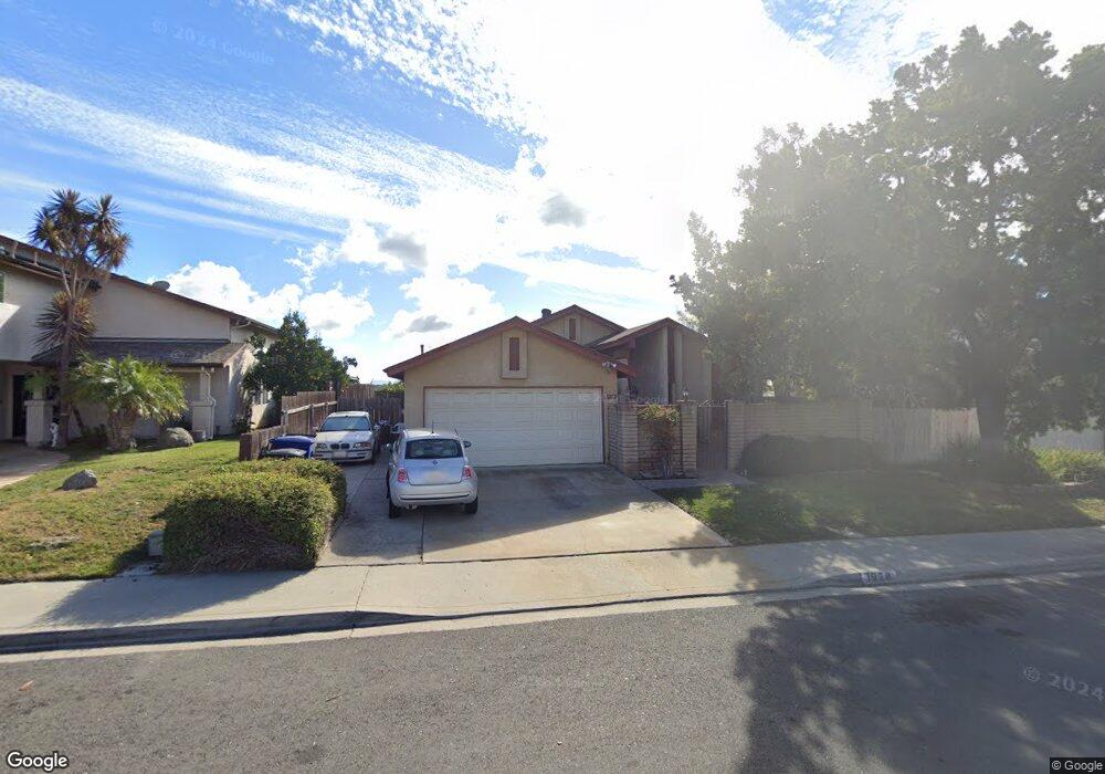
1978 Kent St Chula Vista, CA 91913
Eastlake NeighborhoodEstimated Value: $840,477 - $958,000
4
Beds
2
Baths
1,790
Sq Ft
$507/Sq Ft
Est. Value
About This Home
This home is located at 1978 Kent St, Chula Vista, CA 91913 and is currently estimated at $908,369, approximately $507 per square foot. 1978 Kent St is a home located in San Diego County with nearby schools including Burton C. Tiffany Elementary School, Bonita Vista Middle School, and Bonita Vista Senior High School.
Ownership History
Date
Name
Owned For
Owner Type
Purchase Details
Closed on
Feb 16, 2010
Sold by
Ruiz Antonio J and Trobough Ruiz Rinna
Bought by
Ruiz Antonio J and Trobough Ruiz Rinna
Current Estimated Value
Purchase Details
Closed on
Dec 2, 2009
Sold by
Ruiz Antonio J and Trobough Ruiz Rinna
Bought by
Ruiz Antonio J and Trobough Ruiz Rinna
Purchase Details
Closed on
Feb 6, 1997
Sold by
Roberts Norina R and Trobough Ruiz Rinna
Bought by
Ruiz Antonio J and Trobough Ruiz Rinna
Create a Home Valuation Report for This Property
The Home Valuation Report is an in-depth analysis detailing your home's value as well as a comparison with similar homes in the area
Home Values in the Area
Average Home Value in this Area
Purchase History
| Date | Buyer | Sale Price | Title Company |
|---|---|---|---|
| Ruiz Antonio J | -- | None Available | |
| Ruiz Antonio J | -- | None Available | |
| Ruiz Antonio J | -- | -- |
Source: Public Records
Tax History
| Year | Tax Paid | Tax Assessment Tax Assessment Total Assessment is a certain percentage of the fair market value that is determined by local assessors to be the total taxable value of land and additions on the property. | Land | Improvement |
|---|---|---|---|---|
| 2025 | $1,310 | $110,434 | $22,373 | $88,061 |
| 2024 | $1,310 | $108,270 | $21,935 | $86,335 |
| 2023 | $1,291 | $106,148 | $21,505 | $84,643 |
| 2022 | $1,255 | $104,068 | $21,084 | $82,984 |
| 2021 | $1,227 | $102,028 | $20,671 | $81,357 |
| 2020 | $1,198 | $100,983 | $20,460 | $80,523 |
| 2019 | $1,168 | $99,004 | $20,059 | $78,945 |
| 2018 | $1,150 | $97,064 | $19,666 | $77,398 |
| 2017 | $1,126 | $95,162 | $19,281 | $75,881 |
| 2016 | $1,233 | $93,297 | $18,903 | $74,394 |
| 2015 | $1,084 | $91,897 | $18,620 | $73,277 |
| 2014 | $1,068 | $90,098 | $18,256 | $71,842 |
Source: Public Records
Map
Nearby Homes
- 1929 Duke St
- 1925 Otay Lakes Rd Unit 148
- 1925 Otay Lakes Rd Unit 43
- 1925 Otay Lakes Rd Unit 71
- 1925 Otay Lakes Rd Unit 1
- 1925 Otay Lakes Rd Unit 167
- 1925 Otay Lakes Rd Unit 171
- 1925 Otay Lakes Rd Unit 78
- 2035 Lakeridge Cir Unit 203
- 2063 Lakeridge Cir Unit 101
- 2011 Lakeridge Cir Unit 304
- 749 Brookstone Rd Unit 101
- 2083 Lakeridge Cir Unit 104
- 773 Brookstone Rd Unit 304
- 1753 Ithaca St
- 2140 Waterside Dr
- 1858 Harrils Mill Ave
- 760 Eastshore Terrace Unit 139
- 774 Eastshore Terrace Unit 169
- 744 Eastshore Terrace Unit 102
Your Personal Tour Guide
Ask me questions while you tour the home.