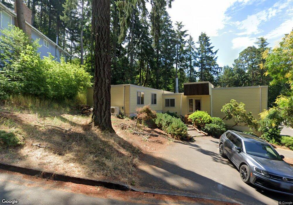
1980 Kimberly Dr Eugene, OR 97405
Southeast Eugene NeighborhoodEstimated Value: $781,257 - $881,000
4
Beds
3
Baths
2,911
Sq Ft
$286/Sq Ft
Est. Value
About This Home
This home is located at 1980 Kimberly Dr, Eugene, OR 97405 and is currently estimated at $833,564, approximately $286 per square foot. 1980 Kimberly Dr is a home located in Lane County with nearby schools including Camas Ridge Community Elementary School, Roosevelt Middle School, and South Eugene High School.
Ownership History
Date
Name
Owned For
Owner Type
Purchase Details
Closed on
Dec 15, 2015
Sold by
Morrow Ray Wilson and Morrow Phyllis A
Bought by
Niesley Joseph Bruce and Niesley Michelle
Current Estimated Value
Create a Home Valuation Report for This Property
The Home Valuation Report is an in-depth analysis detailing your home's value as well as a comparison with similar homes in the area
Home Values in the Area
Average Home Value in this Area
Purchase History
| Date | Buyer | Sale Price | Title Company |
|---|---|---|---|
| Niesley Joseph Bruce | $372,000 | Cascade Title Company |
Source: Public Records
Tax History
| Year | Tax Paid | Tax Assessment Tax Assessment Total Assessment is a certain percentage of the fair market value that is determined by local assessors to be the total taxable value of land and additions on the property. | Land | Improvement |
|---|---|---|---|---|
| 2025 | $9,672 | $496,410 | -- | -- |
| 2024 | $9,213 | $464,887 | -- | -- |
| 2023 | $9,213 | $451,347 | $0 | $0 |
| 2022 | $8,631 | $438,201 | $0 | $0 |
| 2021 | $7,928 | $425,438 | $0 | $0 |
| 2020 | $7,734 | $413,047 | $0 | $0 |
| 2019 | $7,521 | $401,017 | $0 | $0 |
| 2018 | $7,014 | $377,997 | $0 | $0 |
| 2017 | $6,546 | $377,997 | $0 | $0 |
| 2016 | $6,323 | $366,987 | $0 | $0 |
| 2015 | $6,139 | $356,298 | $0 | $0 |
| 2014 | $6,057 | $345,920 | $0 | $0 |
Source: Public Records
Map
Nearby Homes
- 3574 Spring Blvd
- 1996 Kimberly Dr
- 2040 Dogwood Dr
- 3283 Stoney Ridge Rd
- 3945 Spring Blvd
- 3605 Emerald St
- 2082 Golfview Ct
- 3790 Onyx St
- 1210 E 38th Ave
- 0 N Shasta Loop Unit 384285834
- 1180 E 37th Ave
- 4080 Spring Blvd
- 1820 E 28th Ave
- 3817 E Amazon Dr
- 0 Wendell Ln Unit 200453475
- 0 Wendell Ln Unit 279865930
- 0 Wendell Ln Unit 1
- 4835 Elva Ln
- 1755 E 43rd Ave
- 2694 Cupola Dr Unit 21
- 1984 Kimberly Dr
- 1972 Kimberly Dr
- 1796 Craigmont Ave
- 1975 Kimberly Dr
- 3578 Spring Blvd
- 3576 Spring Blvd
- 1981 Kimberly Dr
- 1966 Kimberly Dr
- 1990 Kimberly Dr
- 1963 Kimberly Dr
- 3580 Spring Blvd
- 1960 Kimberly Dr
- 1993 Kimberly Dr
- 1797 Craigmont Ave
- 3588 Spring Blvd
- 3598 Spring Blvd
- 1951 Kimberly Dr
- 1990 Dogwood Dr
- 3610 Spring Blvd
- 1970 Dogwood Dr
Your Personal Tour Guide
Ask me questions while you tour the home.