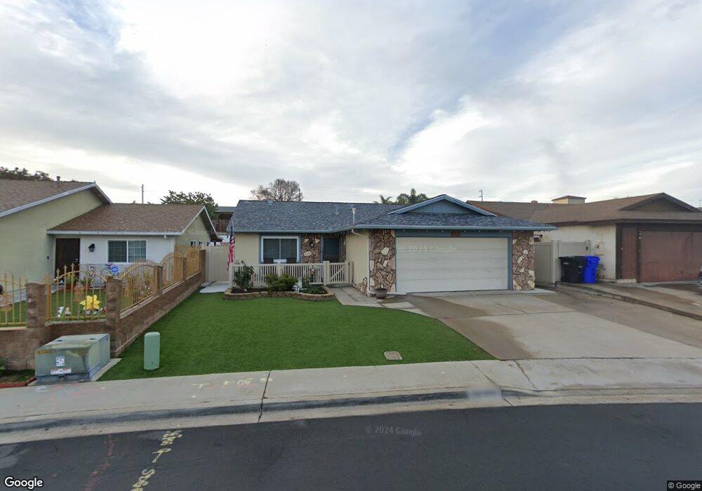
1981 Dunning Cir San Diego, CA 92154
Nestor NeighborhoodEstimated Value: $751,000 - $886,000
4
Beds
2
Baths
1,382
Sq Ft
$578/Sq Ft
Est. Value
About This Home
This home is located at 1981 Dunning Cir, San Diego, CA 92154 and is currently estimated at $798,709, approximately $577 per square foot. 1981 Dunning Cir is a home located in San Diego County with nearby schools including Teofilo Mendoza School, Mar Vista Academy, and Southwest Senior High School.
Ownership History
Date
Name
Owned For
Owner Type
Purchase Details
Closed on
Dec 22, 2014
Sold by
Simpson Linda S and Simpson Billy F
Bought by
Simpson Billy F and Simpson Linda S
Current Estimated Value
Purchase Details
Closed on
Nov 1, 2012
Sold by
Simpson Linda S and Simpson Billy F
Bought by
Simpson Linda S and Simpson Billy F
Home Financials for this Owner
Home Financials are based on the most recent Mortgage that was taken out on this home.
Original Mortgage
$323,500
Outstanding Balance
$141,446
Interest Rate
3.36%
Mortgage Type
New Conventional
Estimated Equity
$657,263
Purchase Details
Closed on
Jan 29, 1990
Bought by
Simpson Billy F Jr Linda S
Create a Home Valuation Report for This Property
The Home Valuation Report is an in-depth analysis detailing your home's value as well as a comparison with similar homes in the area
Home Values in the Area
Average Home Value in this Area
Purchase History
| Date | Buyer | Sale Price | Title Company |
|---|---|---|---|
| Simpson Billy F | -- | None Available | |
| Simpson Linda S | -- | First American Title Company | |
| Simpson Billy F Jr Linda S | $142,500 | -- |
Source: Public Records
Mortgage History
| Date | Status | Borrower | Loan Amount |
|---|---|---|---|
| Open | Simpson Linda S | $323,500 |
Source: Public Records
Tax History Compared to Growth
Tax History
| Year | Tax Paid | Tax Assessment Tax Assessment Total Assessment is a certain percentage of the fair market value that is determined by local assessors to be the total taxable value of land and additions on the property. | Land | Improvement |
|---|---|---|---|---|
| 2025 | $2,942 | $262,130 | $70,045 | $192,085 |
| 2024 | $2,942 | $256,991 | $68,672 | $188,319 |
| 2023 | $2,918 | $251,953 | $67,326 | $184,627 |
| 2022 | $2,861 | $247,013 | $66,006 | $181,007 |
| 2021 | $2,771 | $242,170 | $64,712 | $177,458 |
| 2020 | $2,705 | $239,688 | $64,049 | $175,639 |
| 2019 | $2,702 | $234,990 | $62,794 | $172,196 |
| 2018 | $2,655 | $230,383 | $61,563 | $168,820 |
| 2017 | $80 | $225,866 | $60,356 | $165,510 |
| 2016 | $4,413 | $221,438 | $59,173 | $162,265 |
| 2015 | $4,417 | $218,113 | $58,285 | $159,828 |
| 2014 | $2,460 | $213,842 | $57,144 | $156,698 |
Source: Public Records
Map
Nearby Homes
- 1920 Dunning Cir
- 1035 Sea Glass Way
- 1767 Gentle Current Way
- 1877 Donax Ave
- 2180 Hofer Dr
- 1975 Avenida Del Mexico Unit 216
- 1975 Avenida Del Mexico Unit 217
- 1910 Avenida Del Mexico Unit 102
- 1979 Avenida Del Mexico Unit 128
- 1749-51 Dahlia Ave
- 1384 Frauline Dr
- 1175 Atwater St
- 1165 Hollister St Unit Space 26
- 1640 Halley St
- 2223 Imogene Ave
- 1805 Ionian St
- 2123 Hemlock Ave
- 830 Harwood St
- 1421 Thermal Ave
- 1813 Cheri St Unit A
- 1989 Dunning Cir
- 1973 Dunning Cir
- 1980 Glass Ct
- 1970 Glass Ct
- 1040 Raedel Dr
- 1050 Raedel Dr
- 1060 Raedel Dr
- 1970 Dunning Cir
- 1960 Dunning Cir
- 1061 Saturn Blvd
- 1980 Dunning Cir
- 1063 Saturn Blvd
- 1070 Raedel Dr
- 1960 Glass Ct
- 1965 Dunning Cir
- 1990 Dunning Cir
- 1950 Dunning Cir
- 1961 Dunning Cir
- 1930 Dunning Cir
- 1971 Glass Ct