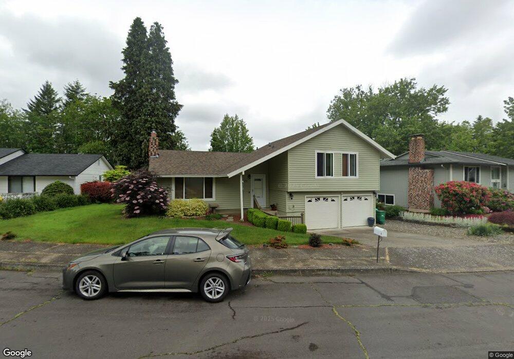
1985 SW Mawrcrest Ct Gresham, OR 97080
Southwest Gresham NeighborhoodEstimated Value: $453,000 - $464,000
3
Beds
2
Baths
1,300
Sq Ft
$353/Sq Ft
Est. Value
About This Home
This home is located at 1985 SW Mawrcrest Ct, Gresham, OR 97080 and is currently estimated at $458,988, approximately $353 per square foot. 1985 SW Mawrcrest Ct is a home located in Multnomah County with nearby schools including Hollydale Elementary School, Dexter McCarty Middle School, and Gresham High School.
Ownership History
Date
Name
Owned For
Owner Type
Purchase Details
Closed on
Apr 8, 1997
Sold by
Tabb James Ray
Bought by
Anderson Eileen M
Current Estimated Value
Home Financials for this Owner
Home Financials are based on the most recent Mortgage that was taken out on this home.
Original Mortgage
$67,667
Interest Rate
7.86%
Mortgage Type
Purchase Money Mortgage
Create a Home Valuation Report for This Property
The Home Valuation Report is an in-depth analysis detailing your home's value as well as a comparison with similar homes in the area
Home Values in the Area
Average Home Value in this Area
Purchase History
| Date | Buyer | Sale Price | Title Company |
|---|---|---|---|
| Anderson Eileen M | $10,000 | Transnation Title Insurance |
Source: Public Records
Mortgage History
| Date | Status | Borrower | Loan Amount |
|---|---|---|---|
| Closed | Anderson Eileen M | $67,667 |
Source: Public Records
Tax History
| Year | Tax Paid | Tax Assessment Tax Assessment Total Assessment is a certain percentage of the fair market value that is determined by local assessors to be the total taxable value of land and additions on the property. | Land | Improvement |
|---|---|---|---|---|
| 2025 | $4,835 | $237,600 | -- | -- |
| 2024 | $4,628 | $230,680 | -- | -- |
| 2023 | $4,217 | $223,970 | $0 | $0 |
| 2022 | $4,099 | $217,450 | $0 | $0 |
| 2021 | $3,996 | $211,120 | $0 | $0 |
| 2020 | $3,760 | $204,980 | $0 | $0 |
| 2019 | $3,661 | $199,010 | $0 | $0 |
| 2018 | $3,491 | $193,220 | $0 | $0 |
| 2017 | $3,350 | $187,600 | $0 | $0 |
| 2016 | $2,953 | $182,140 | $0 | $0 |
Source: Public Records
Map
Nearby Homes
- 1963 SW Myers Place
- 2398 SW Tegart Ave
- 2160 SW 26th St
- 1829 SW 17th St
- 1960 SW 13th Ct
- 2092 SW Thomas Place
- 1859 SW Angeline Ave
- 3605 SW 25th St
- 3519 SW 28th Terrace
- 2607 SW Pleasant View Dr
- 1421 SW Binford Lake Pkwy
- 2520 SW Towle Ave
- 1441 SW 23rd Ct
- 1645 SW 27th St
- 3857 SW Brittany Dr
- 2263 SW Phyllis Place
- 2652 SW Phyllis Dr
- 1261 SW Binford Lake Pkwy
- 1333 SW 19th Dr
- 3503 SW Battaglia Ave
- 1965 SW Mawrcrest Ct
- 1995 SW Mawrcrest Ct
- 1994 SW Myers Place
- 1935 SW Mawrcrest Ct
- 1987 SW Myers Place
- 2005 SW Mawrcrest Ct
- 2012 SW Mawrcrest Ct
- 1962 SW Mawrcrest Ct
- 1972 SW Myers Place
- 1915 SW Mawrcrest Ct
- 2015 SW Mawrcrest Ct
- 1932 SW Mawrcrest Ct
- 2022 SW Mawrcrest Ct
- 2401 SW 20th St
- 1975 SW Myers Place
- 1922 SW Mawrcrest Ct
- 2472 SW 20th St
- 1960 SW Myers Place
- 1905 SW Mawrcrest Ct
- 1895 SW Mawrcrest Ave
Your Personal Tour Guide
Ask me questions while you tour the home.