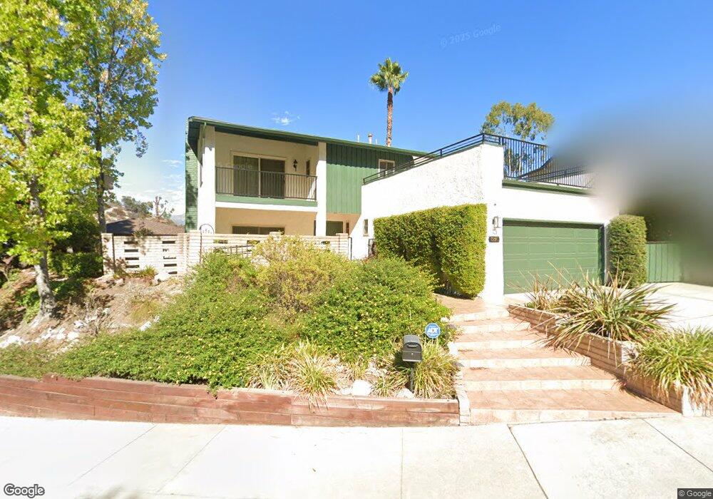
1990 Polaris Dr Glendale, CA 91208
Verdugo Woodlands NeighborhoodEstimated Value: $1,698,558 - $2,517,000
5
Beds
3
Baths
2,436
Sq Ft
$825/Sq Ft
Est. Value
About This Home
This home is located at 1990 Polaris Dr, Glendale, CA 91208 and is currently estimated at $2,008,890, approximately $824 per square foot. 1990 Polaris Dr is a home located in Los Angeles County with nearby schools including Verdugo Woodlands Elementary School, Woodrow Wilson Middle School, and Glendale High School.
Ownership History
Date
Name
Owned For
Owner Type
Purchase Details
Closed on
Sep 5, 2014
Sold by
Grenard Jerry L and Grenard Brenda S
Bought by
The Grenard Family Trust
Current Estimated Value
Purchase Details
Closed on
May 5, 1994
Sold by
Yzurdiaga Joseph and Yzurdiaga Patricia J
Bought by
Grenard Jerry L and Grenard Brenda S
Home Financials for this Owner
Home Financials are based on the most recent Mortgage that was taken out on this home.
Original Mortgage
$346,500
Interest Rate
8.53%
Create a Home Valuation Report for This Property
The Home Valuation Report is an in-depth analysis detailing your home's value as well as a comparison with similar homes in the area
Home Values in the Area
Average Home Value in this Area
Purchase History
| Date | Buyer | Sale Price | Title Company |
|---|---|---|---|
| The Grenard Family Trust | -- | None Available | |
| Grenard Jerry L | $385,000 | North American Title |
Source: Public Records
Mortgage History
| Date | Status | Borrower | Loan Amount |
|---|---|---|---|
| Closed | Grenard Jerry L | $346,500 |
Source: Public Records
Tax History Compared to Growth
Tax History
| Year | Tax Paid | Tax Assessment Tax Assessment Total Assessment is a certain percentage of the fair market value that is determined by local assessors to be the total taxable value of land and additions on the property. | Land | Improvement |
|---|---|---|---|---|
| 2025 | $7,200 | $654,349 | $272,613 | $381,736 |
| 2024 | $7,200 | $641,519 | $267,268 | $374,251 |
| 2023 | $7,038 | $628,941 | $262,028 | $366,913 |
| 2022 | $6,914 | $616,610 | $256,891 | $359,719 |
| 2021 | $6,787 | $604,520 | $251,854 | $352,666 |
| 2019 | $6,528 | $586,591 | $244,385 | $342,206 |
| 2018 | $6,383 | $575,091 | $239,594 | $335,497 |
| 2016 | $6,074 | $552,762 | $230,292 | $322,470 |
| 2015 | $5,950 | $544,460 | $226,833 | $317,627 |
| 2014 | $5,901 | $533,796 | $222,390 | $311,406 |
Source: Public Records
Map
Nearby Homes
- 1438 Hillside Dr
- 1335 Opechee Way
- 1728 Royal Blvd
- 2450 Hermosita Dr
- 1624 Arboles Dr
- 1659 Puebla Dr
- 2707 Hermosita Dr
- 1750 Wabasso Way
- 1815 Las Flores Dr
- 1742 El Rito Ave
- 1971 Deermont Rd
- 1620 Melwood Dr
- 1664 Las Flores Dr
- 1765 Fern Ln
- 2111 Rimcrest Dr
- 0 Pasa Glen Dr Unit 25533579
- 1 Pasa Glen Dr
- 1637 N Verdugo Rd Unit A
- 830 Harrington Rd
- 1824 Crestmont Ct
- 1980 Polaris Dr
- 2000 Polaris Dr
- 1328 Branta Dr
- 1991 Polaris Dr
- 1336 Branta Dr
- 1970 Polaris Dr
- 2007 Polaris Dr
- 1981 Polaris Dr
- 1995 Polaris Dr
- 2001 Polaris Dr
- 1342 Branta Dr
- 1304 Branta Dr
- 1331 Branta Dr
- 1323 Branta Dr
- 1335 Branta Dr
- 1319 Branta Dr
- 1348 Branta Dr
- 1341 Branta Dr
- 1979 Polaris Dr
- 1311 Branta Dr