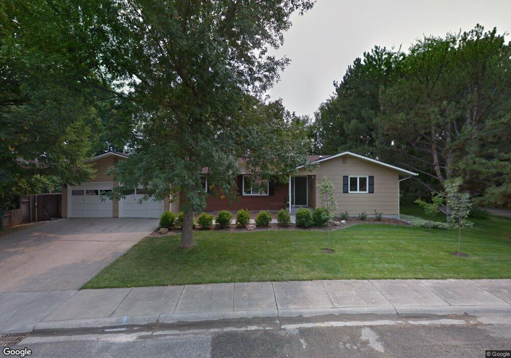
1990 Pryor Ln Billings, MT 59102
North Central Billings NeighborhoodEstimated Value: $452,000 - $600,000
4
Beds
3
Baths
3,748
Sq Ft
$138/Sq Ft
Est. Value
About This Home
This home is located at 1990 Pryor Ln, Billings, MT 59102 and is currently estimated at $517,195, approximately $137 per square foot. 1990 Pryor Ln is a home located in Yellowstone County with nearby schools including Poly Drive School, Lewis & Clark Junior High School, and Billings Senior High School.
Ownership History
Date
Name
Owned For
Owner Type
Purchase Details
Closed on
Jul 8, 2011
Sold by
Wodnik Florence N and Wodnik Joseph Patrick
Bought by
Ando Gregory D and Ando Susan J
Current Estimated Value
Home Financials for this Owner
Home Financials are based on the most recent Mortgage that was taken out on this home.
Original Mortgage
$212,000
Outstanding Balance
$145,253
Interest Rate
4.5%
Mortgage Type
New Conventional
Estimated Equity
$371,942
Purchase Details
Closed on
Nov 11, 2010
Sold by
Wodnick Florence N
Bought by
Wodnick Florence N and Florence N Wodnik Revocable Trust
Purchase Details
Closed on
Oct 3, 2006
Sold by
Wodnik Frank A and Wodnik Florence N
Bought by
Wodnik Frank A and Wodnick Florence N
Create a Home Valuation Report for This Property
The Home Valuation Report is an in-depth analysis detailing your home's value as well as a comparison with similar homes in the area
Home Values in the Area
Average Home Value in this Area
Purchase History
| Date | Buyer | Sale Price | Title Company |
|---|---|---|---|
| Ando Gregory D | -- | None Available | |
| Wodnick Florence N | -- | None Available | |
| Wodnik Frank A | -- | None Available |
Source: Public Records
Mortgage History
| Date | Status | Borrower | Loan Amount |
|---|---|---|---|
| Open | Ando Gregory D | $212,000 |
Source: Public Records
Tax History
| Year | Tax Paid | Tax Assessment Tax Assessment Total Assessment is a certain percentage of the fair market value that is determined by local assessors to be the total taxable value of land and additions on the property. | Land | Improvement |
|---|---|---|---|---|
| 2025 | $3,864 | $529,100 | $62,138 | $466,962 |
| 2024 | $3,864 | $399,300 | $58,900 | $340,400 |
| 2023 | $3,869 | $399,300 | $58,900 | $340,400 |
| 2022 | $3,384 | $358,400 | $0 | $0 |
| 2021 | $3,722 | $358,400 | $0 | $0 |
| 2020 | $3,442 | $315,800 | $0 | $0 |
| 2019 | $3,284 | $315,800 | $0 | $0 |
| 2018 | $3,259 | $308,000 | $0 | $0 |
| 2017 | $2,851 | $308,000 | $0 | $0 |
| 2016 | $2,946 | $289,500 | $0 | $0 |
| 2015 | $2,884 | $313,600 | $0 | $0 |
| 2014 | $2,988 | $160,907 | $0 | $0 |
Source: Public Records
Map
Nearby Homes
- 2042 Green Terrace Dr
- 2103 Poly Dr
- 13 Stanford Ct
- 2124 Dahlia Ln
- 3226 Country Club Cir
- 1807 S Mariposa Ln
- 2406 Woody Dr
- 1944 Colton Blvd
- 1745 Parkhill Dr
- 2504 Rancho Rd
- 1725 Avenue F
- 9 Shadow Place
- 56 Shadow Place
- 1733 Avenue E
- 1449 Teton Ave
- 1440 Granite Ave
- 3540 Masterson Cir
- 2060 Edgewood Dr
- 2644 Rimrock Rd
- 2646 Rimrock Rd
- 1980 Pryor Ln
- 2550 Magnolia Place
- 1970 Pryor Ln
- 2561 Magnolia Place
- 1991 Pryor Ln
- 2011 Pryor Ln
- 2016 Pryor Ln
- 1981 Pryor Ln
- 2540 Magnolia Place
- 2551 Magnolia Place
- 1961 Pryor Ln
- 2621 Orchard Dr
- 1971 Pryor Ln
- 2704 Vigilante Trail
- 2017 Pryor Ln
- 1980 Mckay Ln
- 2541 Magnolia Place
- 1990 Mckay Ln
- 2702 Vigilante Trail
- 2006 Mckay Ln
Your Personal Tour Guide
Ask me questions while you tour the home.