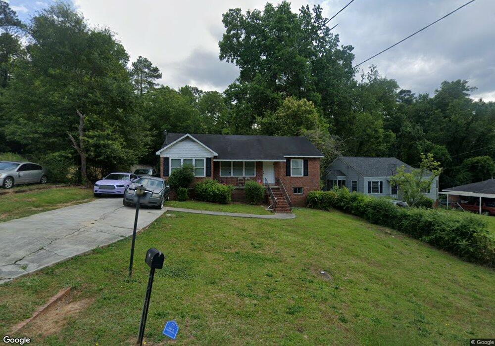
1997 Knightsbridge Rd Macon, GA 31211
Estimated Value: $92,000 - $120,000
3
Beds
1
Bath
1,252
Sq Ft
$81/Sq Ft
Est. Value
About This Home
This home is located at 1997 Knightsbridge Rd, Macon, GA 31211 and is currently estimated at $101,682, approximately $81 per square foot. 1997 Knightsbridge Rd is a home located in Bibb County with nearby schools including Martin Luther King Jr. Elementary School, Appling Middle School, and Northeast High School.
Ownership History
Date
Name
Owned For
Owner Type
Purchase Details
Closed on
Jan 27, 2023
Sold by
Lunsford Family Properties Llc
Bought by
Greenflower 23A Llc
Current Estimated Value
Home Financials for this Owner
Home Financials are based on the most recent Mortgage that was taken out on this home.
Original Mortgage
$5,434,000
Outstanding Balance
$4,260,507
Interest Rate
6.27%
Mortgage Type
New Conventional
Estimated Equity
-$4,158,825
Purchase Details
Closed on
Oct 11, 2013
Sold by
Boland Jo Ozburn
Bought by
Gray Vestors Llc
Purchase Details
Closed on
Mar 30, 1978
Sold by
Mary Mary O and Mary 372
Bought by
Boland Jo O - Fountain Mary
Create a Home Valuation Report for This Property
The Home Valuation Report is an in-depth analysis detailing your home's value as well as a comparison with similar homes in the area
Home Values in the Area
Average Home Value in this Area
Purchase History
| Date | Buyer | Sale Price | Title Company |
|---|---|---|---|
| Greenflower 23A Llc | -- | -- | |
| Gray Vestors Llc | $12,500 | None Available | |
| Boland Jo O - Fountain Mary | -- | -- |
Source: Public Records
Mortgage History
| Date | Status | Borrower | Loan Amount |
|---|---|---|---|
| Open | Greenflower 23A Llc | $5,434,000 |
Source: Public Records
Tax History Compared to Growth
Tax History
| Year | Tax Paid | Tax Assessment Tax Assessment Total Assessment is a certain percentage of the fair market value that is determined by local assessors to be the total taxable value of land and additions on the property. | Land | Improvement |
|---|---|---|---|---|
| 2025 | $903 | $36,759 | $3,680 | $33,079 |
| 2024 | $829 | $32,622 | $2,300 | $30,322 |
| 2023 | $735 | $28,946 | $1,380 | $27,566 |
| 2022 | $678 | $19,592 | $2,346 | $17,246 |
| 2021 | $563 | $14,822 | $1,496 | $13,326 |
| 2020 | $515 | $13,255 | $1,496 | $11,759 |
| 2019 | $519 | $13,255 | $1,496 | $11,759 |
| 2018 | $975 | $13,255 | $1,496 | $11,759 |
| 2017 | $497 | $13,255 | $1,496 | $11,759 |
| 2016 | $442 | $12,785 | $1,496 | $11,289 |
| 2015 | $626 | $12,785 | $1,496 | $11,289 |
| 2014 | $323 | $17,228 | $2,176 | $15,052 |
Source: Public Records
Map
Nearby Homes
- 2458 Tredway Dr
- 2371 Kensington Rd
- 2630 Pauladale Dr
- 2761 Walnut Creek Rd
- 2557 Hyde Park Rd
- 2229 New Clinton Rd
- 2146 Melton Ave
- 2130 New Clinton Rd
- 2815 New Clinton Rd
- 2066 Melton Ave
- 837 Artic Cir
- 1840 Kinder Kare Dr
- 2029 Kitchens Rd
- 1818 Kinder Kare Dr
- 240 Neptune Ct
- 875 Artic Cir
- 875 Artic Place
- 1957 Kitchens Rd
- 1008 Sunnydale Dr
- 1030 Forsyth Ave
- 1989 Knightsbridge Rd
- 2003 Knightsbridge Rd
- 2009 Knightsbridge Rd
- 1981 Knightsbridge Rd
- 1970 Bayswater Rd
- 1980 Bayswater Rd
- 1992 Knightsbridge Rd
- 1962 Bayswater Rd
- 1962 Baywater Rd
- 2004 Knightsbridge Rd
- 2015 Knightsbridge Rd
- 1986 Knightsbridge Rd
- 1965 Knightsbridge Rd
- 2010 Knightsbridge Rd
- 1978 Knightsbridge Rd
- 1954 Bayswater Rd
- 2023 Knightsbridge Rd
- 2016 Knightsbridge Rd
- 2016 Knightsbridge Rd Unit C227
- 1957 Knightsbridge Rd