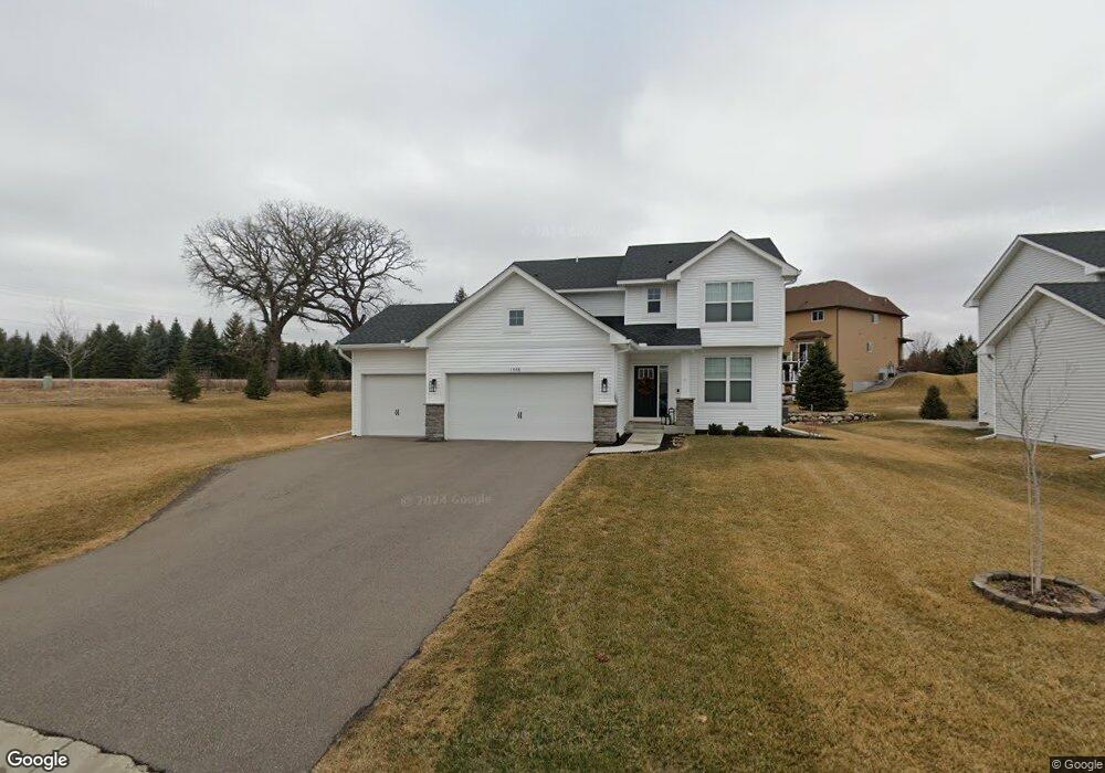
1998 Red Oak Path Shakopee, MN 55379
Estimated Value: $525,000 - $574,000
4
Beds
3
Baths
2,144
Sq Ft
$252/Sq Ft
Est. Value
About This Home
This home is located at 1998 Red Oak Path, Shakopee, MN 55379 and is currently estimated at $541,328, approximately $252 per square foot. 1998 Red Oak Path is a home located in Scott County with nearby schools including Eagle Creek Elementary School, East Middle School, and Shakopee Senior High School.
Ownership History
Date
Name
Owned For
Owner Type
Purchase Details
Closed on
Jul 27, 2022
Sold by
James Williams Kim and James Elizabeth Mark
Bought by
Thornton Tyler S and Thornton Mackenzie
Current Estimated Value
Home Financials for this Owner
Home Financials are based on the most recent Mortgage that was taken out on this home.
Original Mortgage
$533,540
Outstanding Balance
$510,851
Interest Rate
5.7%
Mortgage Type
VA
Estimated Equity
$30,477
Purchase Details
Closed on
Jun 21, 2019
Sold by
Us Home Corporation
Bought by
Williams Kim James and Williams Marit Elizabeth
Home Financials for this Owner
Home Financials are based on the most recent Mortgage that was taken out on this home.
Original Mortgage
$335,000
Interest Rate
4%
Mortgage Type
New Conventional
Create a Home Valuation Report for This Property
The Home Valuation Report is an in-depth analysis detailing your home's value as well as a comparison with similar homes in the area
Home Values in the Area
Average Home Value in this Area
Purchase History
| Date | Buyer | Sale Price | Title Company |
|---|---|---|---|
| Thornton Tyler S | $515,000 | None Listed On Document | |
| Williams Kim James | $385,463 | None Available |
Source: Public Records
Mortgage History
| Date | Status | Borrower | Loan Amount |
|---|---|---|---|
| Open | Thornton Tyler S | $533,540 | |
| Previous Owner | Williams Kim James | $335,000 |
Source: Public Records
Tax History
| Year | Tax Paid | Tax Assessment Tax Assessment Total Assessment is a certain percentage of the fair market value that is determined by local assessors to be the total taxable value of land and additions on the property. | Land | Improvement |
|---|---|---|---|---|
| 2025 | $5,140 | $501,400 | $178,600 | $322,800 |
| 2024 | $5,088 | $488,700 | $170,200 | $318,500 |
| 2023 | $5,122 | $476,300 | $165,200 | $311,100 |
| 2022 | $5,176 | $471,500 | $158,900 | $312,600 |
| 2021 | $4,488 | $408,600 | $131,700 | $276,900 |
| 2020 | $768 | $388,100 | $109,800 | $278,300 |
| 2019 | $1,068 | $101,800 | $101,800 | $0 |
| 2018 | $808 | $0 | $0 | $0 |
Source: Public Records
Map
Nearby Homes
- 1999 Red Oak Path
- 1955 Red Oak
- 7427 Water St
- 7459 Waters Edge Ave
- 7554 Waverly Ave
- 7142 22nd Ave S
- 7660 Waverly Ave
- 7696 Waverly Ave
- 7675 22nd Ave E
- 7698 22nd Ave E
- 7682 22nd Ave E
- 1693 Windsor Dr S
- 1820 Foothill Trail
- 1821 Foothill Trail
- 13200 Henning Cir NE
- 1782 Switchgrass Cir
- 1763 Switchgrass Ct
- 1764 Fescue Ct
- 7506 Hampton Ln
- 8490 Moraine Cir
- 1986 Red Oak Path
- 1983 Oakridge Cir
- 1974 Red Oak Path
- 1975 Oakridge Cir
- 1979 Red Oak Path
- 1987 Red Oak Path
- 1988 Oakridge Cir
- 1962 Red Oak Path
- 1967 Red Oak Path
- 1965 Oakridge Cir
- 1965 1965 Oak Ridge Cir
- 1950 Red Oak Path
- 1950 Red Oath Path
- 1980 Oakridge Cir
- 1948 Eagle Ridge Loop
- 1952 Eagle Ridge Loop
- 1944 Eagle Ridge Loop
- 1951 Oakridge Cir
- 1951 1951 Oak Ridge Cir
- 1956 Eagle Ridge Loop
Your Personal Tour Guide
Ask me questions while you tour the home.