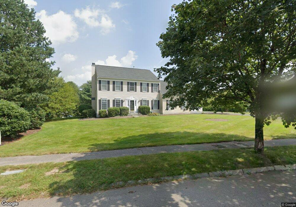
2 Dover Cir Franklin, MA 02038
Estimated Value: $892,849 - $1,073,000
4
Beds
3
Baths
2,719
Sq Ft
$366/Sq Ft
Est. Value
About This Home
This home is located at 2 Dover Cir, Franklin, MA 02038 and is currently estimated at $993,962, approximately $365 per square foot. 2 Dover Cir is a home located in Norfolk County with nearby schools including Helen Keller Elementary School, Annie Sullivan Middle School, and Franklin High School.
Ownership History
Date
Name
Owned For
Owner Type
Purchase Details
Closed on
Apr 6, 2022
Sold by
Desario Rt and Desario
Bought by
Colella Michael T and Colella Casey J
Current Estimated Value
Home Financials for this Owner
Home Financials are based on the most recent Mortgage that was taken out on this home.
Original Mortgage
$300,000
Outstanding Balance
$278,682
Interest Rate
3.89%
Mortgage Type
Purchase Money Mortgage
Estimated Equity
$715,280
Purchase Details
Closed on
Jun 13, 2013
Sold by
Desario George M and Desario Carol M
Bought by
Desario Rt and Desario
Purchase Details
Closed on
Oct 5, 1995
Sold by
Franklin Chase Lp
Bought by
Desario George M and Desario Carol M
Create a Home Valuation Report for This Property
The Home Valuation Report is an in-depth analysis detailing your home's value as well as a comparison with similar homes in the area
Purchase History
| Date | Buyer | Sale Price | Title Company |
|---|---|---|---|
| Colella Michael T | $334,000 | None Available | |
| Desario Rt | -- | -- | |
| Desario Rt | -- | -- | |
| Desario George M | $273,922 | -- | |
| Desario George M | $273,922 | -- |
Source: Public Records
Mortgage History
| Date | Status | Borrower | Loan Amount |
|---|---|---|---|
| Open | Colella Michael T | $300,000 | |
| Previous Owner | Desario George M | $20,000 | |
| Previous Owner | Desario George M | $227,000 | |
| Previous Owner | Desario George M | $15,500 |
Source: Public Records
Tax History
| Year | Tax Paid | Tax Assessment Tax Assessment Total Assessment is a certain percentage of the fair market value that is determined by local assessors to be the total taxable value of land and additions on the property. | Land | Improvement |
|---|---|---|---|---|
| 2025 | $9,982 | $859,000 | $374,900 | $484,100 |
| 2024 | $10,281 | $872,000 | $374,900 | $497,100 |
| 2023 | $9,445 | $750,800 | $318,500 | $432,300 |
| 2022 | $10,013 | $712,700 | $331,800 | $380,900 |
| 2021 | $9,071 | $619,200 | $278,000 | $341,200 |
| 2020 | $8,741 | $602,400 | $278,000 | $324,400 |
| 2019 | $8,786 | $599,300 | $275,100 | $324,200 |
| 2018 | $8,371 | $571,400 | $280,900 | $290,500 |
| 2017 | $8,458 | $580,100 | $289,600 | $290,500 |
| 2016 | $8,013 | $552,600 | $265,500 | $287,100 |
| 2015 | $7,475 | $503,700 | $216,600 | $287,100 |
| 2014 | $7,514 | $520,000 | $232,900 | $287,100 |
Source: Public Records
Map
Nearby Homes
- 48 Dover Cir
- 29 Hancock Rd
- 8 Woodhaven Dr
- 27 Dover Cir
- 29 Elm St
- 254 Daniels St
- 24 Shayne Rd Unit 110
- 839 Lincoln St
- 91 Oliver Pond Cir Unit 3
- 83 Oliver Pond Cir Unit 7
- 253 Village St
- 100 Daniels St
- 41 Kimberlee Ave
- 14 Sanford St Unit 47
- 18 Mary Anne Dr
- 60 Pine St
- 1391 Pond St
- 20 Broad St Unit 1
- 20 Broad St Unit 6
- 20 Broad St Unit A
Your Personal Tour Guide
Ask me questions while you tour the home.