

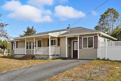
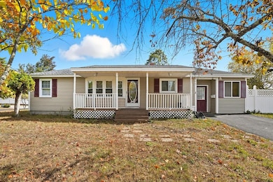
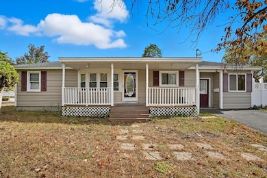
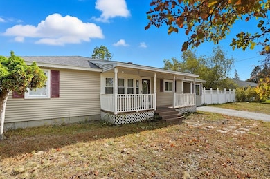
2 Fox Meadow Rd Nashua, NH 03060
South End Nashua NeighborhoodEstimated payment $2,781/month
Total Views
13,065
2
Beds
1
Bath
1,240
Sq Ft
$347
Price per Sq Ft
Highlights
- Deck
- Shed
- Combination Dining and Living Room
- Natural Light
- Garden
- Hot Water Heating System
About This Home
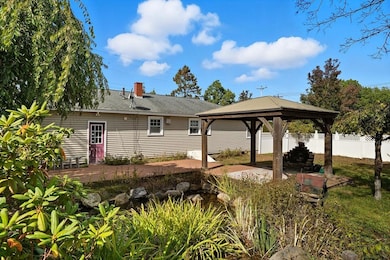
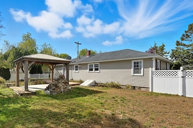
Single level living in Nashua’s south end, ideal for downsizers, first-time buyers, or anyone seeking a manageable home in a convenient location. The property sits on a 0.27-acre lot close to parks, shopping, and commuter routes. A covered farmer’s porch provides a welcoming entry and functional outdoor space. Inside, the home includes approximately 1,220 square feet with two bedrooms, one full bath, and a small bonus room suitable for an office or hobby area. Solid flooring thorughout and the partially finished basement adds useful storage or workspace. Heating is provided by an oil-fired baseboard system with supplemental wood or pellet options. The layout and size support easy maintenance and low utility costs, with strong potential for future energy-efficient upgrades such as improved insulation or window replacements. Outside, a deck overlooks the backyard and a koi pond, creating a low-maintenance outdoor area that’s easy to enjoy. With its single-level design, manageable yard, and proximity to Nashua amenities, this is a practical choice for those looking to simplify without sacrificing comfort or location.
Listing Agent
EXP Realty Brokerage Phone: 603-493-5561 License #048662 Listed on: 10/17/2025
Home Details
Home Type
- Single Family
Est. Annual Taxes
- $6,236
Year Built
- Built in 1959
Lot Details
- 0.28 Acre Lot
- Garden
- Property is zoned R9
Home Design
- Concrete Foundation
- Vinyl Siding
Interior Spaces
- Property has 1 Level
- Natural Light
- Blinds
- Combination Dining and Living Room
- Basement
- Interior Basement Entry
- Carbon Monoxide Detectors
- Microwave
- Washer and Dryer Hookup
Flooring
- Carpet
- Laminate
Bedrooms and Bathrooms
- 2 Bedrooms
- 1 Full Bathroom
Parking
- Driveway
- Paved Parking
Outdoor Features
- Deck
- Shed
- Outbuilding
Location
- City Lot
Schools
- Fairgrounds Elementary School
- Fairgrounds Middle School
- Nashua High School North
Utilities
- Hot Water Heating System
- Cable TV Available
Listing and Financial Details
- Tax Lot 000157
- Assessor Parcel Number 000B
Map
Create a Home Valuation Report for This Property
The Home Valuation Report is an in-depth analysis detailing your home's value as well as a comparison with similar homes in the area
Home Values in the Area
Average Home Value in this Area
Tax History
| Year | Tax Paid | Tax Assessment Tax Assessment Total Assessment is a certain percentage of the fair market value that is determined by local assessors to be the total taxable value of land and additions on the property. | Land | Improvement |
|---|---|---|---|---|
| 2024 | $6,236 | $392,200 | $157,000 | $235,200 |
| 2023 | $5,941 | $325,900 | $125,600 | $200,300 |
| 2022 | $5,889 | $325,900 | $125,600 | $200,300 |
| 2021 | $5,134 | $221,100 | $83,800 | $137,300 |
| 2020 | $4,997 | $221,000 | $83,800 | $137,200 |
| 2019 | $4,809 | $221,000 | $83,800 | $137,200 |
| 2018 | $4,687 | $221,000 | $83,800 | $137,200 |
| 2017 | $4,438 | $172,100 | $72,500 | $99,600 |
| 2016 | $4,315 | $172,100 | $72,500 | $99,600 |
| 2015 | $4,209 | $171,600 | $72,000 | $99,600 |
| 2014 | $4,127 | $171,600 | $72,000 | $99,600 |
Source: Public Records
Property History
| Date | Event | Price | List to Sale | Price per Sq Ft |
|---|---|---|---|---|
| 10/17/2025 10/17/25 | For Sale | $429,900 | -- | $347 / Sq Ft |
Source: PrimeMLS
Purchase History
| Date | Type | Sale Price | Title Company |
|---|---|---|---|
| Warranty Deed | -- | -- | |
| Warranty Deed | $127,300 | -- |
Source: Public Records
Mortgage History
| Date | Status | Loan Amount | Loan Type |
|---|---|---|---|
| Previous Owner | $249,571 | Unknown | |
| Previous Owner | $245,883 | Unknown | |
| Previous Owner | $127,184 | Purchase Money Mortgage |
Source: Public Records
About the Listing Agent
Suzanne Damon—The No-Pressure Agent
A long-time resident of the Manchester, NH area, Suzanne Damon has been a powerhouse in real estate for the past 29 years. Ranked among the top-producing agents in both New Hampshire and the United States, she leads The Damon Home Team with expertise, integrity, and a deep commitment to her clients.
Suzanne’s entrepreneurial spirit started early—at just seven years old, she was pulling a wagon through the city, selling flowers from her garden. That same
Suzanne's Other Listings
Source: PrimeMLS
MLS Number: 5066268
APN: 29,502
Disclaimer: Certain information contained herein is derived from information provided by parties other than Homes.com. All information provided is deemed reliable, but is not guaranteed to be accurate and should be independently verified.
![]() Copyright 2025 PrimeMLS, Inc. All rights reserved. This information is deemed reliable, but not guaranteed. The data relating to real estate displayed on this display comes in part from the IDX Program of PrimeMLS. The information being provided is for consumers’ personal, non-commercial use and may not be used for any purpose other than to identify prospective properties consumers may be interested in purchasing.
Copyright 2025 PrimeMLS, Inc. All rights reserved. This information is deemed reliable, but not guaranteed. The data relating to real estate displayed on this display comes in part from the IDX Program of PrimeMLS. The information being provided is for consumers’ personal, non-commercial use and may not be used for any purpose other than to identify prospective properties consumers may be interested in purchasing.
Nearby Homes
- 13 Bramble Dr
- 29 Greenwood Dr
- 17 Herrick St
- 28 Nottingham Dr
- 1 Hayden St
- 15 Learned St Unit 123
- 23 Glen Dr
- 30 Clearview Dr
- 30 Dexter St Unit 106
- 70 Linwood St
- 36 Eastman St Unit 26
- 33 Cannon Dr
- 22 Kern Dr
- 6 Lake Ave
- 11 Bordeaux St
- 4 Henry David Dr Unit 203
- 19.5 Balcom St
- 10 Zellwood St
- 8 Cote Ave
- 13 Wason Ave Unit 29
- 15 Kingston Dr
- 177 Chestnut St
- 26 Pittsburgh Dr
- 32 Gilman St
- 53 Congress St
- 73 Kinsley St Unit B
- 104 Pine St Unit 4
- 101 W Hollis St Unit 2
- 2 Grand Ave Unit 7
- 57 Palm St
- 3 Perry Ave
- 30 Ledge St Unit 4
- 1 Storage Dr
- 42 Bowery St
- 69 Walnut St
- 8 Digital Dr
- 5 Avery Ln
- 19 Myrtle St
- 97 Linton St Unit 214
- 44 High St