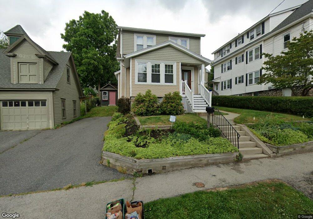
2 Loring St Worcester, MA 01606
Indian Lake East NeighborhoodEstimated Value: $378,000 - $407,000
3
Beds
1
Bath
1,165
Sq Ft
$337/Sq Ft
Est. Value
About This Home
This home is located at 2 Loring St, Worcester, MA 01606 and is currently estimated at $392,225, approximately $336 per square foot. 2 Loring St is a home located in Worcester County with nearby schools including Francis J. McGrath Elementary School, Jacob Hiatt Magnet School, and Chandler Magnet.
Ownership History
Date
Name
Owned For
Owner Type
Purchase Details
Closed on
May 3, 1996
Sold by
Bankers Trust Co
Bought by
Jolin Venus A
Current Estimated Value
Home Financials for this Owner
Home Financials are based on the most recent Mortgage that was taken out on this home.
Original Mortgage
$35,200
Interest Rate
7.82%
Mortgage Type
Purchase Money Mortgage
Purchase Details
Closed on
Jul 12, 1995
Sold by
Johnson William R
Bought by
Bankers Trust Co
Purchase Details
Closed on
Jun 5, 1989
Sold by
Lindberg Richard
Bought by
Johnson William
Home Financials for this Owner
Home Financials are based on the most recent Mortgage that was taken out on this home.
Original Mortgage
$90,100
Interest Rate
10.92%
Mortgage Type
Purchase Money Mortgage
Create a Home Valuation Report for This Property
The Home Valuation Report is an in-depth analysis detailing your home's value as well as a comparison with similar homes in the area
Home Values in the Area
Average Home Value in this Area
Purchase History
| Date | Buyer | Sale Price | Title Company |
|---|---|---|---|
| Jolin Venus A | $44,000 | -- | |
| Bankers Trust Co | $59,500 | -- | |
| Johnson William | $97,500 | -- |
Source: Public Records
Mortgage History
| Date | Status | Borrower | Loan Amount |
|---|---|---|---|
| Open | Johnson William | $36,000 | |
| Closed | Johnson William | $35,200 | |
| Previous Owner | Johnson William | $90,100 |
Source: Public Records
Tax History Compared to Growth
Tax History
| Year | Tax Paid | Tax Assessment Tax Assessment Total Assessment is a certain percentage of the fair market value that is determined by local assessors to be the total taxable value of land and additions on the property. | Land | Improvement |
|---|---|---|---|---|
| 2025 | $4,014 | $304,300 | $97,900 | $206,400 |
| 2024 | $3,854 | $280,300 | $97,900 | $182,400 |
| 2023 | $3,695 | $257,700 | $85,100 | $172,600 |
| 2022 | $3,396 | $223,300 | $68,100 | $155,200 |
| 2021 | $3,223 | $198,000 | $54,500 | $143,500 |
| 2020 | $3,079 | $181,100 | $54,500 | $126,600 |
| 2019 | $2,956 | $164,200 | $49,000 | $115,200 |
| 2018 | $2,954 | $156,200 | $49,000 | $107,200 |
| 2017 | $2,814 | $146,400 | $49,000 | $97,400 |
| 2016 | $2,885 | $140,000 | $36,400 | $103,600 |
| 2015 | $2,561 | $127,600 | $36,400 | $91,200 |
| 2014 | $2,493 | $127,600 | $36,400 | $91,200 |
Source: Public Records
Map
Nearby Homes
- 89 W Boylston St Unit 4
- 6 Roald St
- 44 Boardman St
- 23 Dryden St
- 577 Grove St
- 10 Dryden St Unit 7
- 37 Kenwood Ave
- 11 Holden St
- 0 Grove St
- 63 North St Unit A
- 63 North St Unit B
- 15 Ericsson St
- 27 Harlow St
- 3 Shoreham St
- 40 Westwood Dr
- 667 Grove St
- 65 Paine St
- 8 Old Colony Rd
- 39 Whitmarsh Ave
- 82 Holden St
- 4 Loring St
- 4 Loring St Unit 2
- 16 Huntington Ave
- 14 Tower St
- 18 Huntington Ave
- 1 Loring St
- 10 Huntington Ave
- 5 Loring St
- 22 Tower St
- 7 Loring St
- 8 Loring St
- 17 Huntington Ave
- 15 Huntington Ave
- 13 Huntington Ave
- 20 Huntington Ave
- 17A Huntington Ave
- 11 Huntington Ave
- 83 W Boylston St Unit 6
- 83 W Boylston St Unit 5
- 83 W Boylston St Unit 4