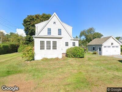
2 Payson Rd Falmouth, ME 04105
Falmouth Foreside NeighborhoodEstimated Value: $783,396 - $983,000
3
Beds
3
Baths
1,902
Sq Ft
$455/Sq Ft
Est. Value
About This Home
This home is located at 2 Payson Rd, Falmouth, ME 04105 and is currently estimated at $866,349, approximately $455 per square foot. 2 Payson Rd is a home with nearby schools including Falmouth Middle School, Falmouth High School, and Baxter Academy for Tech & Sciences.
Ownership History
Date
Name
Owned For
Owner Type
Purchase Details
Closed on
Mar 6, 2007
Sold by
Jordan Ellen J
Bought by
Jordan John R
Current Estimated Value
Home Financials for this Owner
Home Financials are based on the most recent Mortgage that was taken out on this home.
Original Mortgage
$205,000
Interest Rate
6.27%
Mortgage Type
Unknown
Create a Home Valuation Report for This Property
The Home Valuation Report is an in-depth analysis detailing your home's value as well as a comparison with similar homes in the area
Home Values in the Area
Average Home Value in this Area
Purchase History
| Date | Buyer | Sale Price | Title Company |
|---|---|---|---|
| Jordan John R | -- | -- |
Source: Public Records
Mortgage History
| Date | Status | Borrower | Loan Amount |
|---|---|---|---|
| Open | Jordan John R | $198,697 | |
| Closed | Jordan John R | $100,000 | |
| Closed | Jordan John R | $205,000 |
Source: Public Records
Tax History Compared to Growth
Tax History
| Year | Tax Paid | Tax Assessment Tax Assessment Total Assessment is a certain percentage of the fair market value that is determined by local assessors to be the total taxable value of land and additions on the property. | Land | Improvement |
|---|---|---|---|---|
| 2023 | $5,764 | $456,000 | $199,100 | $256,900 |
| 2022 | $5,436 | $456,000 | $199,100 | $256,900 |
| 2021 | $4,643 | $266,400 | $122,800 | $143,600 |
| 2020 | $10,221 | $266,400 | $122,800 | $143,600 |
| 2019 | $4,494 | $266,400 | $122,800 | $143,600 |
| 2018 | $4,388 | $266,400 | $122,800 | $143,600 |
| 2017 | $8,931 | $266,400 | $122,800 | $143,600 |
| 2016 | $8,622 | $256,400 | $122,800 | $133,600 |
| 2015 | $3,748 | $256,200 | $122,800 | $133,400 |
| 2014 | $3,612 | $256,200 | $122,800 | $133,400 |
| 2012 | -- | $256,200 | $122,800 | $133,400 |
Source: Public Records
Map
Nearby Homes
- 9 Phillips Rd
- 72 Us Route 1
- 5 Cobblestone St Unit 53
- 11 Mckinley Rd
- 56 Carroll St
- 17 Us Route 1
- 66 Colonial Village
- 1040 Ocean Ave
- 42 Wordsworth St
- 157 Veranda St
- 75 Clearwater Dr Unit 305
- 48 Ridge Rd Unit 3
- 8 Joshua Way
- 20 Upland Ave
- 178 Ridge Rd Unit 26
- 784 Ocean Ave
- 121 Providence St
- 17 Wildwood Cir
- 12 Cleaves Farm Rd
- 301 Sherwood St