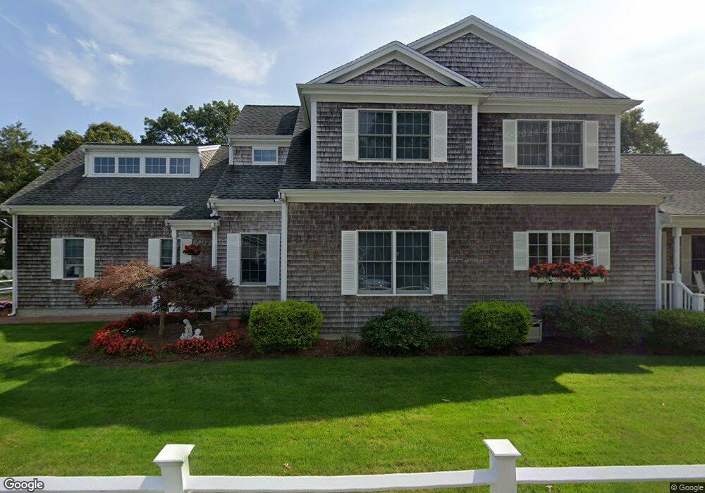
2 Seconsett Point Rd Mashpee, MA 02649
Seconsett Island NeighborhoodEstimated Value: $1,531,000 - $1,645,000
3
Beds
3
Baths
3,344
Sq Ft
$474/Sq Ft
Est. Value
About This Home
This home is located at 2 Seconsett Point Rd, Mashpee, MA 02649 and is currently estimated at $1,583,799, approximately $473 per square foot. 2 Seconsett Point Rd is a home located in Barnstable County with nearby schools including Kenneth C. Coombs School, Quashnet School, and Mashpee Middle School.
Ownership History
Date
Name
Owned For
Owner Type
Purchase Details
Closed on
Feb 27, 2008
Sold by
Strazzullo Frank C and Strazzullo Janice M
Bought by
Strazzullo Frank C and Strazzullo Janice M
Current Estimated Value
Purchase Details
Closed on
Feb 25, 1994
Sold by
Seconsett Rt and Haven Esmin
Bought by
Strazzullo Frank C and Strazzullo Janice R
Purchase Details
Closed on
Nov 29, 1988
Sold by
Hathaway Lester R
Bought by
Haven Kent O
Create a Home Valuation Report for This Property
The Home Valuation Report is an in-depth analysis detailing your home's value as well as a comparison with similar homes in the area
Home Values in the Area
Average Home Value in this Area
Purchase History
| Date | Buyer | Sale Price | Title Company |
|---|---|---|---|
| Strazzullo Frank C | -- | -- | |
| Strazzullo Frank C | -- | -- | |
| Strazzullo Frank C | $130,000 | -- | |
| Strazzullo Frank C | $130,000 | -- | |
| Haven Kent O | $130,000 | -- |
Source: Public Records
Mortgage History
| Date | Status | Borrower | Loan Amount |
|---|---|---|---|
| Closed | Haven Kent O | $0 |
Source: Public Records
Tax History
| Year | Tax Paid | Tax Assessment Tax Assessment Total Assessment is a certain percentage of the fair market value that is determined by local assessors to be the total taxable value of land and additions on the property. | Land | Improvement |
|---|---|---|---|---|
| 2025 | $7,595 | $1,147,300 | $365,700 | $781,600 |
| 2024 | $6,987 | $1,086,700 | $332,500 | $754,200 |
| 2023 | $6,381 | $910,300 | $292,200 | $618,100 |
| 2022 | $6,119 | $748,900 | $237,600 | $511,300 |
| 2021 | $5,993 | $660,700 | $214,000 | $446,700 |
| 2020 | $5,826 | $640,900 | $205,800 | $435,100 |
| 2019 | $5,712 | $631,200 | $223,000 | $408,200 |
| 2018 | $5,608 | $628,700 | $223,000 | $405,700 |
| 2017 | $5,731 | $623,600 | $223,000 | $400,600 |
| 2016 | $5,538 | $599,400 | $223,000 | $376,400 |
| 2015 | $5,310 | $582,900 | $223,000 | $359,900 |
| 2014 | $4,828 | $514,200 | $188,200 | $326,000 |
Source: Public Records
Map
Nearby Homes
- 15 Seconsett Point Rd
- 24 Seconsett Point Rd
- 50 Topping Lift
- 197 Monomoscoy Rd
- 9 Point Rd
- 5 Tide Run
- 16 Quinns Way Unit 16
- 16 Quinns Way
- 381 Great Oak Rd Unit 9
- 35 Bayshore Dr
- 5 Rivers View Rd
- 51 Walton Heath Way
- 51 Fairway Ln
- 22 Mid Iron Way Unit 7511
- 97 Walton Heath Way
- 63 Ellsworth Dr
- 63 Ovington Dr
- 72 Woodside Dr
- 240 Surf Dr
- 16 Slice Way
- 71 Seconsett Island Rd
- 8 Seconsett Point Rd
- 75 Seconsett Island Rd
- 61 Seconsett Island Rd
- 62 Seconsett Island Rd
- 79 Seconsett Island Rd
- 68 Seconsett Island Rd
- 9 Seconsett Point Rd
- 72 Seconsett Island Rd
- 5 Kanter Ln
- 10 Tulip Shell Way
- 76 Seconsett Island Rd
- 57 Seconsett Island Rd
- 9 Tulip Shell Way
- 14 Tulip Shell Way
- 56 Seconsett Island Rd
- 6 Kanter Ln
- 16 Seconsett Point Rd
- 53 Seconsett Island Rd
- 14 Seconsett Point Rd
Your Personal Tour Guide
Ask me questions while you tour the home.