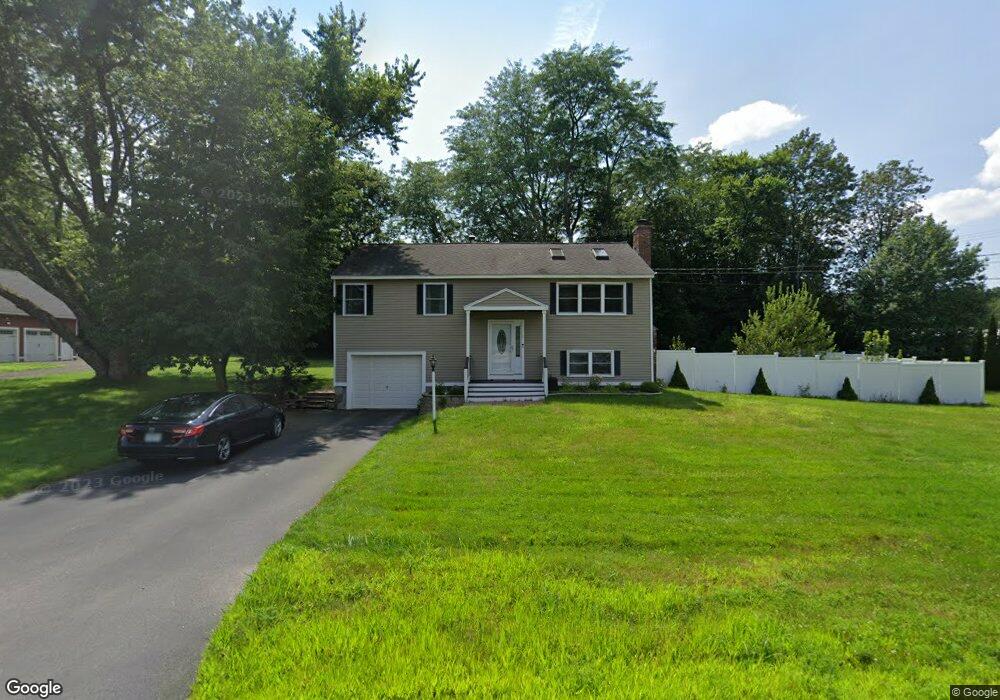
2 Wilshire Dr Londonderry, NH 03053
Estimated Value: $502,000 - $528,000
2
Beds
1
Bath
1,080
Sq Ft
$479/Sq Ft
Est. Value
About This Home
This home is located at 2 Wilshire Dr, Londonderry, NH 03053 and is currently estimated at $516,947, approximately $478 per square foot. 2 Wilshire Dr is a home with nearby schools including Matthew Thornton Elementary School, Londonderry Middle School, and Londonderry Senior High School.
Ownership History
Date
Name
Owned For
Owner Type
Purchase Details
Closed on
Jun 21, 2005
Sold by
Holohan Michael T
Bought by
Rennick Jason S
Current Estimated Value
Home Financials for this Owner
Home Financials are based on the most recent Mortgage that was taken out on this home.
Original Mortgage
$204,000
Interest Rate
5.78%
Mortgage Type
Unknown
Purchase Details
Closed on
Sep 30, 1996
Sold by
Cogavin Paul and Cogavin Beth
Bought by
Trubee Gerald M and Trubee Joanne E
Create a Home Valuation Report for This Property
The Home Valuation Report is an in-depth analysis detailing your home's value as well as a comparison with similar homes in the area
Home Values in the Area
Average Home Value in this Area
Purchase History
| Date | Buyer | Sale Price | Title Company |
|---|---|---|---|
| Rennick Jason S | $255,000 | -- | |
| Trubee Gerald M | $97,500 | -- |
Source: Public Records
Mortgage History
| Date | Status | Borrower | Loan Amount |
|---|---|---|---|
| Open | Rennick Jason S | $25,000 | |
| Open | Trubee Gerald M | $199,000 | |
| Closed | Trubee Gerald M | $224,000 | |
| Closed | Trubee Gerald M | $32,000 | |
| Closed | Rennick Jason S | $204,000 | |
| Closed | Rennick Jason S | $51,000 |
Source: Public Records
Tax History Compared to Growth
Tax History
| Year | Tax Paid | Tax Assessment Tax Assessment Total Assessment is a certain percentage of the fair market value that is determined by local assessors to be the total taxable value of land and additions on the property. | Land | Improvement |
|---|---|---|---|---|
| 2024 | $7,345 | $455,100 | $200,200 | $254,900 |
| 2023 | $7,329 | $468,300 | $200,200 | $268,100 |
| 2022 | $7,246 | $392,100 | $150,000 | $242,100 |
| 2021 | $7,207 | $392,100 | $150,000 | $242,100 |
| 2020 | $6,719 | $334,100 | $112,600 | $221,500 |
| 2019 | $6,478 | $334,100 | $112,600 | $221,500 |
| 2018 | $5,823 | $267,100 | $93,900 | $173,200 |
| 2017 | $5,772 | $267,100 | $93,900 | $173,200 |
| 2016 | $5,078 | $236,200 | $93,900 | $142,300 |
| 2015 | $4,965 | $236,200 | $93,900 | $142,300 |
| 2014 | $4,981 | $236,200 | $93,900 | $142,300 |
| 2011 | -- | $236,800 | $93,900 | $142,900 |
Source: Public Records
Map
Nearby Homes
- 31 Midridge Cir
- 27 Midridge Cir
- 214 Winding Pond Rd
- 90 High Range Rd
- 88 High Range Rd
- 111 Winterwood Dr
- 6 Wiley Hill Rd
- 47 Winding Pond Rd
- 267 Winding Pond Rd
- 11 Elise Ave Unit Lot 91
- 12 Wiley Hill Rd
- 17 Lily Ln
- 19 Lily Ln
- 1 Lily Ln
- 3 Chandler Dr
- 74 Boulder Dr Unit 74
- 14 Mohawk Dr
- 5 Delphi Way
- 3 Delphi Way
- 7 Delphi Way
- 163 Pillsbury Rd
- 1 Wilshire Dr
- 3 Wilshire Dr
- 165 Pillsbury Rd
- 162 Pillsbury Rd
- 4 Wilshire Dr
- 11 Berkshire Ln
- 7 Wilshire Dr
- 167 Pillsbury Rd
- 164 Pillsbury Rd
- 9 Berkshire Ln
- 7 Berkshire Ln
- 9 Wilshire Dr
- 6 Wilshire Dr
- 12 Berkshire Ln
- 10 Berkshire Ln
- 169 Pillsbury Rd
- 168 Pillsbury Rd
- 5 Berkshire Ln
- 8 Berkshire Ln