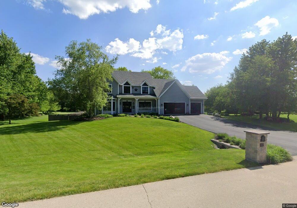
20 Chippewa Ct Oswego, IL 60543
South Oswego NeighborhoodEstimated Value: $600,000 - $718,000
5
Beds
4
Baths
2,575
Sq Ft
$255/Sq Ft
Est. Value
About This Home
This home is located at 20 Chippewa Ct, Oswego, IL 60543 and is currently estimated at $656,450, approximately $254 per square foot. 20 Chippewa Ct is a home located in Kendall County with nearby schools including Hunt Club Elementary School, Traughber Junior High School, and Oswego High School.
Ownership History
Date
Name
Owned For
Owner Type
Purchase Details
Closed on
Apr 18, 2025
Sold by
Burke Claire Catherine and Burke Charles Patrick
Bought by
Claire Catherine Burke Living Trust and Burke
Current Estimated Value
Purchase Details
Closed on
Sep 29, 2017
Sold by
Janoski Joseph A and Janoski Patricia K
Bought by
Burke Claire C
Home Financials for this Owner
Home Financials are based on the most recent Mortgage that was taken out on this home.
Original Mortgage
$320,000
Interest Rate
3.99%
Mortgage Type
New Conventional
Purchase Details
Closed on
May 1, 1994
Bought by
Janoski Joseph and Janoski Patricia
Create a Home Valuation Report for This Property
The Home Valuation Report is an in-depth analysis detailing your home's value as well as a comparison with similar homes in the area
Home Values in the Area
Average Home Value in this Area
Purchase History
| Date | Buyer | Sale Price | Title Company |
|---|---|---|---|
| Claire Catherine Burke Living Trust | -- | None Listed On Document | |
| Burke Claire C | $400,000 | Near North National Title | |
| Janoski Joseph | $62,900 | -- |
Source: Public Records
Mortgage History
| Date | Status | Borrower | Loan Amount |
|---|---|---|---|
| Previous Owner | Burke Claire C | $320,000 | |
| Closed | Janoski Joseph | -- |
Source: Public Records
Tax History
| Year | Tax Paid | Tax Assessment Tax Assessment Total Assessment is a certain percentage of the fair market value that is determined by local assessors to be the total taxable value of land and additions on the property. | Land | Improvement |
|---|---|---|---|---|
| 2024 | $11,666 | $164,984 | $25,612 | $139,372 |
| 2023 | $11,383 | $149,760 | $24,392 | $125,368 |
| 2022 | $11,383 | $143,796 | $24,392 | $119,404 |
| 2021 | $11,952 | $145,985 | $24,763 | $121,222 |
| 2020 | $11,992 | $143,927 | $24,414 | $119,513 |
| 2019 | $12,166 | $143,927 | $24,414 | $119,513 |
| 2018 | $11,411 | $131,321 | $22,276 | $109,045 |
| 2017 | $11,283 | $125,460 | $22,276 | $103,184 |
| 2016 | $10,587 | $116,485 | $22,001 | $94,484 |
| 2015 | $10,512 | $110,549 | $20,880 | $89,669 |
| 2014 | -- | $101,547 | $20,880 | $80,667 |
| 2013 | -- | $101,547 | $20,880 | $80,667 |
Source: Public Records
Map
Nearby Homes
- 53 Abbeyfeale Dr
- 51 Crestview Dr
- 4541 Waa-Kee-sha Dr
- 5500 Half Hollow Ct
- 7267 Roberts Ct
- 7555 Fairway Dr
- 7400 Roberts Dr
- 5983 Championship Ct
- 7751 Bentgrass Cir
- 5508 Legend Dr
- 4215 Southerland Dr
- 4700 Laughton Ave
- 5751 Audrey Ave
- 5021 Minkler Rd
- 83 Oak Creek Dr
- 539 Sudbury Cir
- 7542 Thornhill Ct
- 68 Oak Creek Dr
- Lot #3 Rose Hill Ct
- 55 Oak Creek Dr
- 14 Chippewa Ct
- 17 Chippewa Ct
- 23 Chippewa Ct
- 32 Chippewa Ct
- 73 Chippewa Ct
- 73 Chippewa Dr
- 29 Chippewa Ct
- 10 Chippewa Ct
- 35 Chippewa Ct
- 9 Chippewa Ct
- 6 Chippewa Ct
- 61 Chippewa Dr
- 2 Chippewa Ct
- 5 Chippewa Ct
- 1 Chippewa Ct
- 8 Iroquois Ct
- 12 Iroquois Ct
- 15 Iroquois Ct
- 88 W Timberlake Trail
- 90 W Timberlake Trail
Your Personal Tour Guide
Ask me questions while you tour the home.