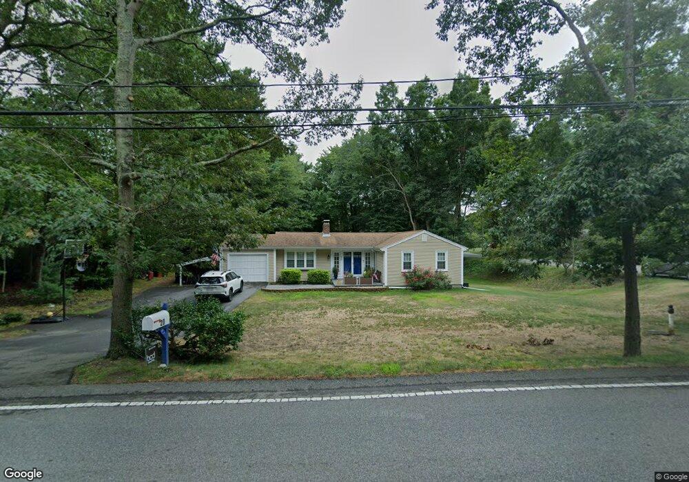
20 Circuit St Hanover, MA 02339
Estimated Value: $598,000 - $749,000
2
Beds
2
Baths
1,316
Sq Ft
$521/Sq Ft
Est. Value
About This Home
This home is located at 20 Circuit St, Hanover, MA 02339 and is currently estimated at $685,243, approximately $520 per square foot. 20 Circuit St is a home located in Plymouth County with nearby schools including Hanover High School, Cadence Academy Preschool - Hanover, and Cardinal Cushing Centers.
Ownership History
Date
Name
Owned For
Owner Type
Purchase Details
Closed on
Dec 26, 2007
Sold by
Blanchard Kenneth and Blanchard David
Bought by
Jorgenson Michael L and Accomando Jaclyn N
Current Estimated Value
Home Financials for this Owner
Home Financials are based on the most recent Mortgage that was taken out on this home.
Original Mortgage
$295,000
Interest Rate
6.27%
Mortgage Type
Purchase Money Mortgage
Purchase Details
Closed on
Feb 28, 2007
Sold by
Blanchard Kenneth L and Blanchard David
Bought by
Blanchard Wendell D and Blanchard Kenneth
Purchase Details
Closed on
Mar 8, 2005
Sold by
Blanchard Wendell D
Bought by
Blanchard David and Blanchard Kenneth
Create a Home Valuation Report for This Property
The Home Valuation Report is an in-depth analysis detailing your home's value as well as a comparison with similar homes in the area
Home Values in the Area
Average Home Value in this Area
Purchase History
| Date | Buyer | Sale Price | Title Company |
|---|---|---|---|
| Jorgenson Michael L | $295,000 | -- | |
| Blanchard Wendell D | -- | -- | |
| Blanchard David | -- | -- | |
| Blanchard Wendell D | -- | -- |
Source: Public Records
Mortgage History
| Date | Status | Borrower | Loan Amount |
|---|---|---|---|
| Open | Blanchard Wendell D | $302,706 | |
| Closed | Blanchard Wendell D | $295,000 |
Source: Public Records
Tax History Compared to Growth
Tax History
| Year | Tax Paid | Tax Assessment Tax Assessment Total Assessment is a certain percentage of the fair market value that is determined by local assessors to be the total taxable value of land and additions on the property. | Land | Improvement |
|---|---|---|---|---|
| 2025 | $7,030 | $569,200 | $269,400 | $299,800 |
| 2024 | $7,309 | $569,200 | $269,400 | $299,800 |
| 2023 | $6,933 | $513,900 | $244,900 | $269,000 |
| 2022 | $6,751 | $442,700 | $232,700 | $210,000 |
| 2021 | $6,426 | $393,500 | $189,200 | $204,300 |
| 2020 | $6,506 | $398,900 | $200,300 | $198,600 |
| 2019 | $6,172 | $376,100 | $200,300 | $175,800 |
| 2018 | $5,999 | $368,500 | $200,300 | $168,200 |
| 2017 | $5,894 | $356,800 | $199,000 | $157,800 |
| 2016 | $5,447 | $323,100 | $181,000 | $142,100 |
| 2015 | $4,724 | $292,500 | $167,600 | $124,900 |
Source: Public Records
Map
Nearby Homes
- 250 Center St
- 51 Cervelli Farm Dr
- 37 Dr
- 23 Cervelli Farm Dr
- 38 Cervelli Farm Dr
- 9 Cervelli Farm Dr
- 8 Old Farm Rd
- 436 Center St
- 553 Center St
- 62 Larchmont Ln
- 154 Winter St
- 67 School St
- 41 Gail Rd
- 265 Silver St
- 21 King St
- 1251 Broadway
- 114 Graham Hill Dr
- Lot 22 Adams Cir
- 14 Longwood Ln Unit 14
- 842 E Washington St