
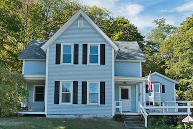
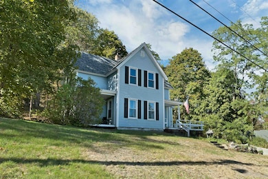
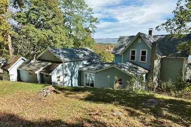
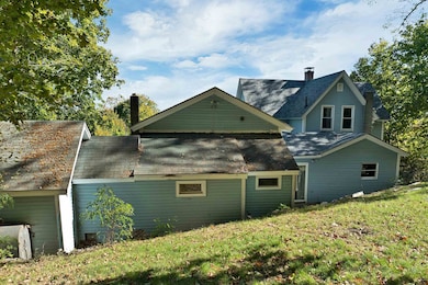
20 Coe Hill Rd Center Harbor, NH 03226
Center Harbor NeighborhoodEstimated payment $3,068/month
Highlights
- Water Access
- Deck
- Wooded Lot
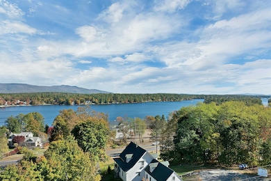
- Lake View
- Lake, Pond or Stream
- Softwood Flooring
About This Home
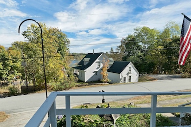
You just HAVE to check this out! At $176/SF, this is a rare opportunity for a primary home, vacation retreat, investment, or multi-use conversion. Hardly ever does a property SO close to Center Harbor Village come to market—especially with approx. 3,000 SF of living space and seasonal views of Lake Winnipesaukee. This classic 1870 New England-style home offers a flexible 3+ bedroom layout with 2.5 baths. The main level includes a spacious living room with decorative fireplace, formal dining room, and den. The kitchen features custom wood cabinetry, newer appliances, and a cozy breakfast nook. The attached barn has been reimagined as a rustic family room with half bath, brick hearth, and spiral staircase leading to a private suite with 3/4 bath and dual closets. Upstairs in the main house: two bedrooms, full bath, and laundry room—with potential to restore a third bedroom. The .29 acre lot rises gently, offering abundant privacy and a large front deck with sweeping seasonal lake views. Facing east, enjoy the morning light and mountain air. Leave the car and walk to the village center for coffee, summer concerts, dining, groceries, and entertainment. Center Harbor's resident beach, pickleball, basketball, and playground are steps away! So are the post office, town hall, and library! Public sewer, paved driveway, and off-street parking add convenience! Location, value, and potential - all in one! Just compare!
Listing Agent
KW Coastal and Lakes & Mountains Realty/Meredith License #004871 Listed on: 07/03/2025

Home Details
Home Type
- Single Family
Est. Annual Taxes
- $3,614
Year Built
- Built in 1870
Lot Details
- 0.29 Acre Lot
- Property fronts a private road
- Interior Lot
- Sloped Lot
- Wooded Lot
Property Views
- Lake
- Mountain
Home Design
- New Englander Architecture
- Shingle Roof
- Vinyl Siding
Interior Spaces
- Property has 2 Levels
- Woodwork
- Fireplace
- Natural Light
- Family Room
- Living Room
- Den
- Basement
- Interior Basement Entry
- Laundry Room
Kitchen
- Breakfast Area or Nook
- Gas Range
- Microwave
- Dishwasher
Flooring
- Softwood
- Carpet
- Tile
- Vinyl
Bedrooms and Bathrooms
- 3 Bedrooms
- En-Suite Bathroom
Parking
- Driveway
- Paved Parking
- On-Site Parking
- Off-Street Parking
- 1 to 5 Parking Spaces
Outdoor Features
- Water Access
- Water Access Across The Street
- Municipal Residents Have Water Access Only
- Lake, Pond or Stream
- Deck
- Shed
Schools
- Inter-Lakes Elementary School
- Inter-Lakes Middle School
- Inter-Lakes High School
Utilities
- Radiator
- Space Heater
- Hot Water Heating System
- Generator Hookup
- Private Water Source
- Well
- Drilled Well
Community Details
- Trails
Listing and Financial Details
- Tax Block 038
- Assessor Parcel Number 103
Map
Home Values in the Area
Average Home Value in this Area
Tax History
| Year | Tax Paid | Tax Assessment Tax Assessment Total Assessment is a certain percentage of the fair market value that is determined by local assessors to be the total taxable value of land and additions on the property. | Land | Improvement |
|---|---|---|---|---|
| 2024 | $3,468 | $324,430 | $75,900 | $248,530 |
| 2023 | $3,179 | $324,430 | $75,900 | $248,530 |
| 2022 | $2,917 | $324,430 | $75,900 | $248,530 |
| 2021 | $3,577 | $234,260 | $59,400 | $174,860 |
| 2020 | $3,524 | $229,860 | $59,400 | $170,460 |
| 2019 | $3,498 | $229,860 | $59,400 | $170,460 |
| 2018 | $3,296 | $229,860 | $59,400 | $170,460 |
| 2017 | $3,190 | $229,860 | $59,400 | $170,460 |
| 2016 | $3,162 | $219,900 | $39,600 | $180,300 |
| 2015 | $3,162 | $219,900 | $39,600 | $180,300 |
| 2013 | $2,900 | $219,900 | $39,600 | $180,300 |
Property History
| Date | Event | Price | List to Sale | Price per Sq Ft |
|---|---|---|---|---|
| 10/07/2025 10/07/25 | Price Changed | $525,000 | -11.8% | $176 / Sq Ft |
| 09/05/2025 09/05/25 | Price Changed | $595,000 | -7.8% | $200 / Sq Ft |
| 08/11/2025 08/11/25 | Price Changed | $645,000 | -0.8% | $216 / Sq Ft |
| 07/23/2025 07/23/25 | Price Changed | $650,000 | -3.7% | $218 / Sq Ft |
| 07/03/2025 07/03/25 | For Sale | $675,000 | -- | $227 / Sq Ft |
Purchase History
| Date | Type | Sale Price | Title Company |
|---|---|---|---|
| Quit Claim Deed | -- | None Available | |
| Quit Claim Deed | -- | None Available | |
| Warranty Deed | $207,000 | -- |
Mortgage History
| Date | Status | Loan Amount | Loan Type |
|---|---|---|---|
| Open | $110,000 | Adjustable Rate Mortgage/ARM | |
| Closed | $110,000 | Adjustable Rate Mortgage/ARM | |
| Previous Owner | $165,600 | Purchase Money Mortgage |
Source: PrimeMLS
MLS Number: 5049855
APN: CHBR-000103-000000-000038
Disclaimer: Certain information contained herein is derived from information provided by parties other than Homes.com. All information provided is deemed reliable, but is not guaranteed to be accurate and should be independently verified.
![]() Copyright 2025 PrimeMLS, Inc. All rights reserved. This information is deemed reliable, but not guaranteed. The data relating to real estate displayed on this display comes in part from the IDX Program of PrimeMLS. The information being provided is for consumers’ personal, non-commercial use and may not be used for any purpose other than to identify prospective properties consumers may be interested in purchasing.
Copyright 2025 PrimeMLS, Inc. All rights reserved. This information is deemed reliable, but not guaranteed. The data relating to real estate displayed on this display comes in part from the IDX Program of PrimeMLS. The information being provided is for consumers’ personal, non-commercial use and may not be used for any purpose other than to identify prospective properties consumers may be interested in purchasing.
- 24 Dew Point Ln
- 52 Chase Cir
- 00 Whittier Hwy Unit 8
- 122 Coe Hill Rd
- 38 Lake Shore Dr Unit 12
- 38 Lake Shore Dr Unit 10
- 320 Redding Ln
- 11 Jennifer's Path
- 00 Gilman Hill Rd
- 145 Hanson Dr
- 21 Burton Rd
- 33 Blackadar Ln
- 203 Krainewood Dr
- 53 Bay Dr
- 22 Tiger Trail
- 1 Little Beaver Island
- 30 Leopards Leap
- 525 Whittier Hwy
- 4 Schneider Rd
- 100 Marvin Rd
- 58 Patrician Shores Cir
- 105 Red Hill Rd
- 11 Laurel Glen Ln
- 15 Homestead Ln
- 25 Quarry Rd Unit A
- 222 College Rd
- 242 High Haith Rd
- 92 Singing Eagle Rd
- 100 Singing Eagle Rd
- 495 Center Harbor Neck Rd
- 17 Lake St Unit 1
- 14 Lake Shore Dr
- 14 Lake Shore Dr
- 14 Lake Shore Dr
- 27 Loch Eden Shores Rd
- 959 Whittier Hwy Unit Winnipesaukee Commons Unit #4
- 9 Westbury Rd
- 6 Neal Shore Rd
- 168 Coolidge Farm Rd
- 7 Paugus Rd