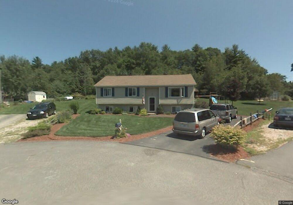
20 Conifer St MerriMacK, NH 03054
Estimated Value: $529,546 - $587,000
3
Beds
2
Baths
1,990
Sq Ft
$280/Sq Ft
Est. Value
About This Home
This home is located at 20 Conifer St, MerriMacK, NH 03054 and is currently estimated at $557,137, approximately $279 per square foot. 20 Conifer St is a home located in Hillsborough County with nearby schools including James Mastricola Elementary School, James Mastricola Upper Elementary School, and Merrimack Middle School.
Ownership History
Date
Name
Owned For
Owner Type
Purchase Details
Closed on
Apr 3, 2018
Sold by
Wozniak Kimberly
Bought by
Wozniak Kimberly
Current Estimated Value
Home Financials for this Owner
Home Financials are based on the most recent Mortgage that was taken out on this home.
Original Mortgage
$100,000
Outstanding Balance
$86,932
Interest Rate
4.45%
Mortgage Type
Credit Line Revolving
Estimated Equity
$470,205
Purchase Details
Closed on
Nov 20, 1987
Bought by
Wozniak Ross S and Wozniak Stanley J
Create a Home Valuation Report for This Property
The Home Valuation Report is an in-depth analysis detailing your home's value as well as a comparison with similar homes in the area
Home Values in the Area
Average Home Value in this Area
Purchase History
Date | Buyer | Sale Price | Title Company |
---|---|---|---|
Wozniak Kimberly | -- | -- | |
Wozniak Ross S | -- | -- |
Source: Public Records
Mortgage History
Date | Status | Borrower | Loan Amount |
---|---|---|---|
Open | Wozniak Kimberly | $100,000 | |
Previous Owner | Wozniak Ross S | $157,000 | |
Previous Owner | Wozniak Ross S | $60,000 |
Source: Public Records
Tax History Compared to Growth
Tax History
Year | Tax Paid | Tax Assessment Tax Assessment Total Assessment is a certain percentage of the fair market value that is determined by local assessors to be the total taxable value of land and additions on the property. | Land | Improvement |
---|---|---|---|---|
2024 | $7,531 | $364,000 | $181,700 | $182,300 |
2023 | $7,080 | $364,000 | $181,700 | $182,300 |
2022 | $6,326 | $364,000 | $181,700 | $182,300 |
2021 | $6,250 | $364,000 | $181,700 | $182,300 |
2020 | $6,234 | $259,100 | $132,800 | $126,300 |
2019 | $6,252 | $259,100 | $132,800 | $126,300 |
2018 | $6,249 | $259,100 | $132,800 | $126,300 |
2017 | $6,055 | $259,100 | $132,800 | $126,300 |
2016 | $5,905 | $259,100 | $132,800 | $126,300 |
2015 | $5,275 | $213,400 | $115,800 | $97,600 |
2014 | $5,141 | $213,400 | $115,800 | $97,600 |
2013 | $5,102 | $213,400 | $115,800 | $97,600 |
Source: Public Records
Map
Nearby Homes
- 12 Conifer St
- 19 Turkey Hill Rd
- 33 Currier Rd
- 3 Powderhouse Rd
- 3 Timber Ln
- 29 Woodland Dr
- 10 John Ln
- 15 Fox Meadow Ln
- 32 Valleyview Dr
- 7 Franconia Dr
- 8 Bowman Ct
- 205 Indian Rock Rd
- 155 Indian Rock Rd
- 15 McElwain St
- 22 Gray Hawk Rd
- 6 Whitetail Ridge
- 1 Village Falls Way
- 7 Joston Dr
- 40 Abenaki Cir
- 19 Joston Dr