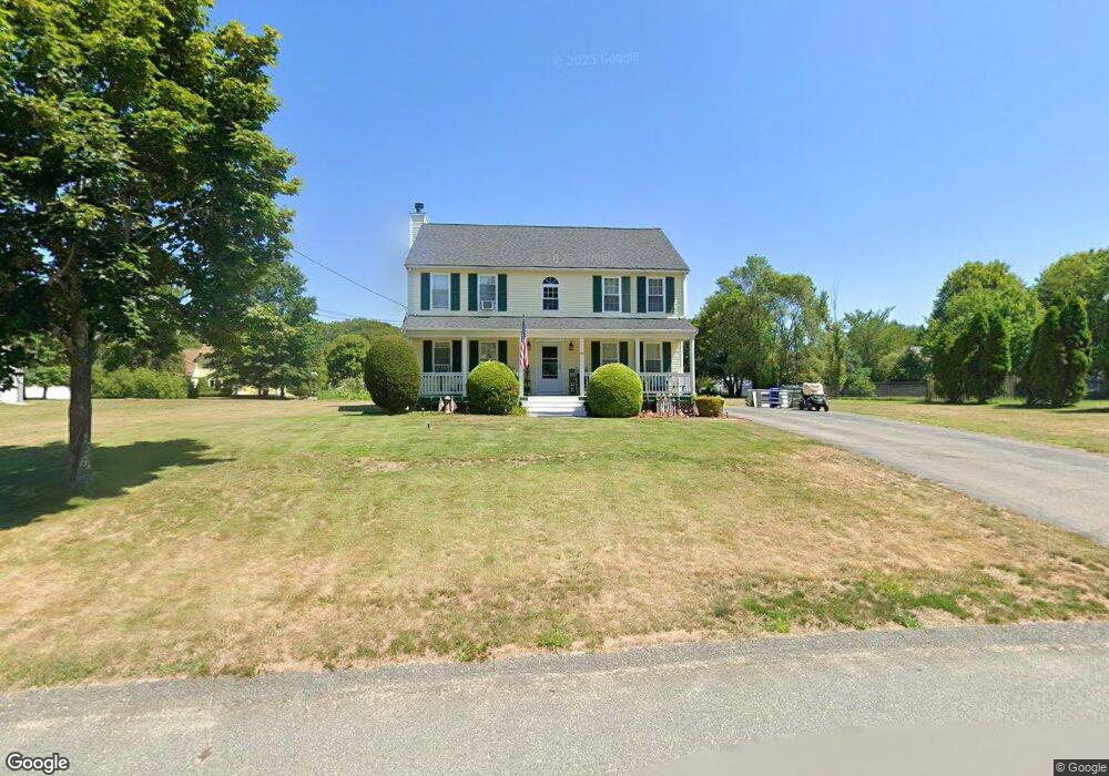
20 Frontier Dr Attleboro, MA 02703
Estimated Value: $625,093 - $716,000
4
Beds
2
Baths
1,821
Sq Ft
$364/Sq Ft
Est. Value
About This Home
This home is located at 20 Frontier Dr, Attleboro, MA 02703 and is currently estimated at $662,023, approximately $363 per square foot. 20 Frontier Dr is a home located in Bristol County with nearby schools including Thomas E. Willett School, Cyril K. Brennan Middle School, and Attleboro High School.
Ownership History
Date
Name
Owned For
Owner Type
Purchase Details
Closed on
Apr 30, 1998
Sold by
Cedar Ridge Dev Inc
Bought by
Martin Christopher C and Martin Heather
Current Estimated Value
Home Financials for this Owner
Home Financials are based on the most recent Mortgage that was taken out on this home.
Original Mortgage
$158,100
Outstanding Balance
$30,730
Interest Rate
7.04%
Mortgage Type
Purchase Money Mortgage
Estimated Equity
$631,293
Create a Home Valuation Report for This Property
The Home Valuation Report is an in-depth analysis detailing your home's value as well as a comparison with similar homes in the area
Home Values in the Area
Average Home Value in this Area
Purchase History
| Date | Buyer | Sale Price | Title Company |
|---|---|---|---|
| Martin Christopher C | $168,100 | -- |
Source: Public Records
Mortgage History
| Date | Status | Borrower | Loan Amount |
|---|---|---|---|
| Open | Martin Christopher C | $158,100 |
Source: Public Records
Tax History
| Year | Tax Paid | Tax Assessment Tax Assessment Total Assessment is a certain percentage of the fair market value that is determined by local assessors to be the total taxable value of land and additions on the property. | Land | Improvement |
|---|---|---|---|---|
| 2025 | $6,714 | $535,000 | $189,200 | $345,800 |
| 2024 | $6,800 | $534,200 | $208,000 | $326,200 |
| 2023 | $6,137 | $448,300 | $182,600 | $265,700 |
| 2022 | $5,718 | $395,700 | $161,400 | $234,300 |
| 2021 | $5,381 | $363,600 | $155,200 | $208,400 |
| 2020 | $5,103 | $350,500 | $147,200 | $203,300 |
| 2019 | $4,889 | $345,300 | $144,400 | $200,900 |
| 2018 | $4,691 | $316,500 | $140,200 | $176,300 |
| 2017 | $4,689 | $322,300 | $145,800 | $176,500 |
| 2016 | $4,526 | $305,400 | $136,300 | $169,100 |
| 2015 | $4,409 | $299,700 | $136,300 | $163,400 |
| 2014 | $4,344 | $292,500 | $131,000 | $161,500 |
Source: Public Records
Map
Nearby Homes
- 345 Richardson Ave
- 10 Walter St
- 71 Richardson Ave
- 20 John F. Kennedy Dr
- 4 Village Way Unit F
- 933 Pleasant St
- 123 Pike Ave
- 14 Country Club Way
- 451R Gilbert St
- 49 Pheasant Hill Rd
- 0 Pike Ave
- 37 Oakleaf Dr
- 63 Hope St
- 10 Hazelwood Ct
- 143 Oak St Unit 10
- 11 Cherry Tree Ln
- 678 N Main St
- 2 Oak St Unit 2A
- 2 Oak St Unit 2B
- 747 N Main St
Your Personal Tour Guide
Ask me questions while you tour the home.