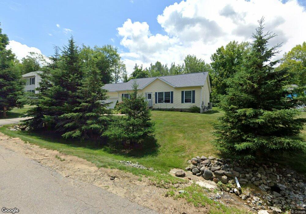
20 Lady Bug Ln Franklin, NH 03235
Estimated Value: $382,000 - $446,000
3
Beds
2
Baths
1,732
Sq Ft
$238/Sq Ft
Est. Value
About This Home
This home is located at 20 Lady Bug Ln, Franklin, NH 03235 and is currently estimated at $411,519, approximately $237 per square foot. 20 Lady Bug Ln is a home with nearby schools including Paul A. Smith School, Franklin Middle School, and Franklin High School.
Ownership History
Date
Name
Owned For
Owner Type
Purchase Details
Closed on
Sep 30, 2004
Sold by
Hill Franklin Cricke
Bought by
Pauline R Sargent T
Current Estimated Value
Home Financials for this Owner
Home Financials are based on the most recent Mortgage that was taken out on this home.
Original Mortgage
$135,000
Interest Rate
5.81%
Mortgage Type
Purchase Money Mortgage
Create a Home Valuation Report for This Property
The Home Valuation Report is an in-depth analysis detailing your home's value as well as a comparison with similar homes in the area
Home Values in the Area
Average Home Value in this Area
Purchase History
| Date | Buyer | Sale Price | Title Company |
|---|---|---|---|
| Pauline R Sargent T | $202,400 | -- |
Source: Public Records
Mortgage History
| Date | Status | Borrower | Loan Amount |
|---|---|---|---|
| Open | Pauline R Sargent T | $126,000 | |
| Closed | Pauline R Sargent T | $128,000 | |
| Closed | Pauline R Sargent T | $135,000 |
Source: Public Records
Tax History Compared to Growth
Tax History
| Year | Tax Paid | Tax Assessment Tax Assessment Total Assessment is a certain percentage of the fair market value that is determined by local assessors to be the total taxable value of land and additions on the property. | Land | Improvement |
|---|---|---|---|---|
| 2024 | $5,275 | $307,600 | $89,100 | $218,500 |
| 2023 | $5,002 | $307,600 | $89,100 | $218,500 |
| 2022 | $4,858 | $199,200 | $73,400 | $125,800 |
| 2021 | $4,507 | $194,200 | $73,400 | $120,800 |
| 2020 | $4,436 | $194,200 | $73,400 | $120,800 |
| 2019 | $4,364 | $194,200 | $73,400 | $120,800 |
| 2018 | $4,262 | $194,100 | $73,400 | $120,700 |
| 2017 | $4,453 | $174,200 | $43,700 | $130,500 |
| 2016 | $4,393 | $174,100 | $43,700 | $130,400 |
| 2015 | $3,041 | $121,870 | $30,590 | $91,280 |
| 2011 | $3,891 | $180,800 | $35,200 | $145,600 |
Source: Public Records
Map
Nearby Homes
- 28 Leach Ave
- 99 Pleasant St
- 24 Munroe St Unit 2
- 24 Munroe St Unit 1&2
- 24 Munroe St Unit 1
- 721 Central St
- 152 Prospect St
- 624 Central St
- 48 Millstone Dr Unit 58
- 50 Millstone Dr Unit 57
- 12 Village Way Unit 38
- 39 Village Way Unit 21
- 41 Village Way Unit 22
- 28 Maple Square
- 12 Stonehenge Cir
- 88 Franklin St
- 46 Sanborn St
- 416 Central St
- 82-84 Woodridge Rd
- 75 School St