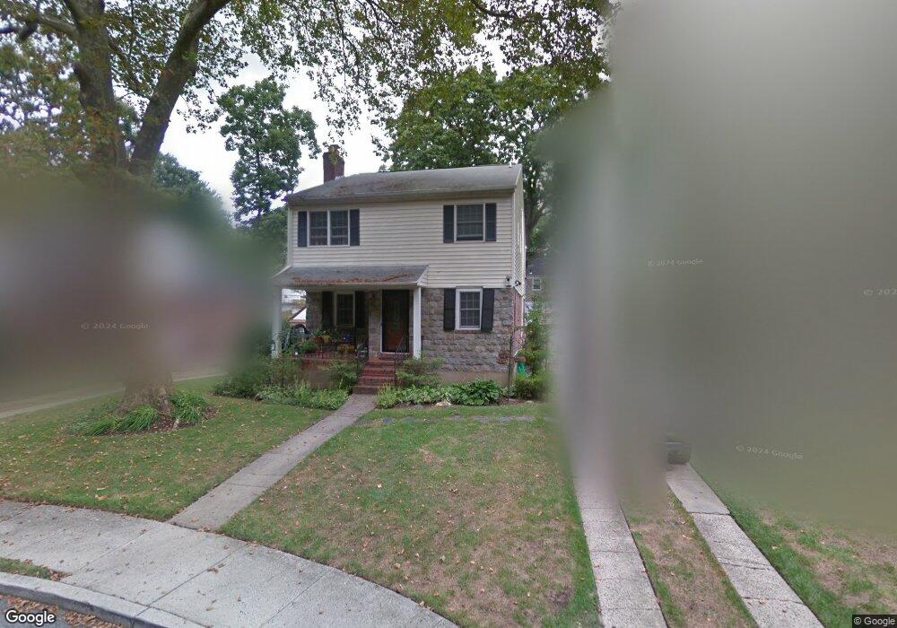
20 Mayfair Ct Freeport, NY 11520
Estimated Value: $724,407 - $729,000
Studio
3
Baths
1,860
Sq Ft
$391/Sq Ft
Est. Value
About This Home
This home is located at 20 Mayfair Ct, Freeport, NY 11520 and is currently estimated at $726,704, approximately $390 per square foot. 20 Mayfair Ct is a home located in Nassau County with nearby schools including Caroline G. Atkinson Intermediate School, Columbus Avenue School, and John W Dodd Middle School.
Ownership History
Date
Name
Owned For
Owner Type
Purchase Details
Closed on
Oct 21, 2010
Sold by
Evans Rodney and Brewington James
Bought by
Viala Rayginald and Ashwood Shana
Current Estimated Value
Home Financials for this Owner
Home Financials are based on the most recent Mortgage that was taken out on this home.
Original Mortgage
$353,243
Outstanding Balance
$231,556
Interest Rate
4.22%
Mortgage Type
FHA
Estimated Equity
$495,148
Create a Home Valuation Report for This Property
The Home Valuation Report is an in-depth analysis detailing your home's value as well as a comparison with similar homes in the area
Home Values in the Area
Average Home Value in this Area
Purchase History
| Date | Buyer | Sale Price | Title Company |
|---|---|---|---|
| Viala Rayginald | $358,000 | -- |
Source: Public Records
Mortgage History
| Date | Status | Borrower | Loan Amount |
|---|---|---|---|
| Open | Viala Rayginald | $353,243 |
Source: Public Records
Tax History
| Year | Tax Paid | Tax Assessment Tax Assessment Total Assessment is a certain percentage of the fair market value that is determined by local assessors to be the total taxable value of land and additions on the property. | Land | Improvement |
|---|---|---|---|---|
| 2025 | $8,936 | $456 | $121 | $335 |
| 2024 | $1,027 | $456 | $121 | $335 |
Source: Public Records
Map
Nearby Homes
- 2098 Felix Ct
- 883 Mckenna Ave
- 15 Mckenna Ave
- 215 N Brookside Ave
- 89 Delaware Ave
- 1850 Voshage St
- 720 New York Ave
- 2 Florence St
- 1 Willowbrook Ln
- 1878 Lake Dr W
- 60 Connecticut Ave
- 2316 Harrison Ave
- 139 New York Ave
- 757 Bixby Dr
- 120 Lena Ave
- 661 Saint Lukes Place
- 623 Ashland Ave
- 619 Ashland Ave
- 161 Wallace St
- 101 Wallace St
- 16 Mayfair Ct
- 24 Mayfair Ct
- 15 Mayflower Ct
- 23 Mayflower Ct
- 10 Mayfair Ct
- 9 Mayflower Ct
- 11 Mayfair Ct
- 11 Mayfair Ct
- 107 N Brookside Ave
- 117 N Brookside Ave
- 3 Mayfair Ct
- 3 Mayfair Ct
- 16 Mayflower Ct
- 26 Mayflower Ct
- 10 Mayflower Ct
- 91 N Brookside Ave
- 127 N Brookside Ave
- 12 Felix Ct
- 108 N Brookside Ave
- 17 Meadowbrook Ct
Your Personal Tour Guide
Ask me questions while you tour the home.