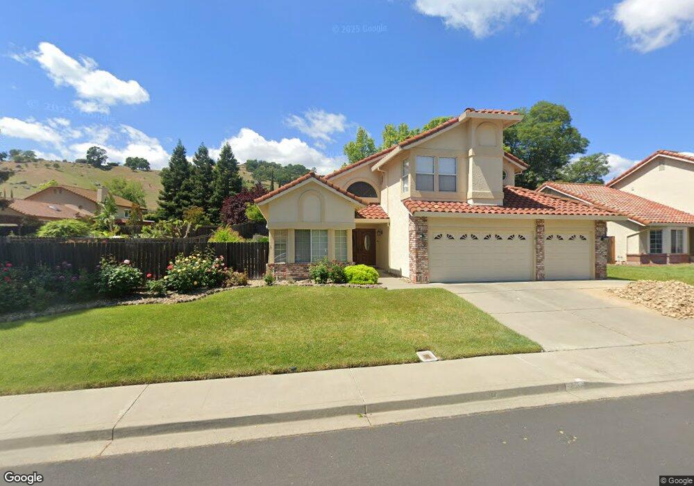
200 Wrentham Dr Vacaville, CA 95688
Estimated Value: $718,346 - $811,000
5
Beds
3
Baths
2,286
Sq Ft
$337/Sq Ft
Est. Value
About This Home
This home is located at 200 Wrentham Dr, Vacaville, CA 95688 and is currently estimated at $770,337, approximately $336 per square foot. 200 Wrentham Dr is a home located in Solano County with nearby schools including Browns Valley Elementary School, Willis Jepson Middle School, and Vacaville High School.
Ownership History
Date
Name
Owned For
Owner Type
Purchase Details
Closed on
Jun 28, 2023
Sold by
Fehr Michael A
Bought by
Michael Allen Fehr Trust and Fehr
Current Estimated Value
Purchase Details
Closed on
Aug 16, 2000
Sold by
Fehr Nancy A
Bought by
Fehr Michael A
Home Financials for this Owner
Home Financials are based on the most recent Mortgage that was taken out on this home.
Original Mortgage
$205,000
Interest Rate
8.16%
Purchase Details
Closed on
Aug 9, 2000
Sold by
Fehr Michael A and Fehr Nancy A
Bought by
Fehr Michael A
Home Financials for this Owner
Home Financials are based on the most recent Mortgage that was taken out on this home.
Original Mortgage
$205,000
Interest Rate
8.16%
Purchase Details
Closed on
Sep 14, 1994
Sold by
Fehr Michael A and Fehr Nancy A
Bought by
Fehr Michael A and Fehr Nancy A
Create a Home Valuation Report for This Property
The Home Valuation Report is an in-depth analysis detailing your home's value as well as a comparison with similar homes in the area
Purchase History
| Date | Buyer | Sale Price | Title Company |
|---|---|---|---|
| Michael Allen Fehr Trust | -- | None Listed On Document | |
| Fehr Michael A | -- | -- | |
| Fehr Michael A | -- | Frontier Title Company | |
| Fehr Michael A | -- | -- |
Source: Public Records
Mortgage History
| Date | Status | Borrower | Loan Amount |
|---|---|---|---|
| Previous Owner | Fehr Michael A | $205,000 |
Source: Public Records
Tax History
| Year | Tax Paid | Tax Assessment Tax Assessment Total Assessment is a certain percentage of the fair market value that is determined by local assessors to be the total taxable value of land and additions on the property. | Land | Improvement |
|---|---|---|---|---|
| 2025 | $5,224 | $447,346 | $132,814 | $314,532 |
| 2024 | $5,224 | $438,575 | $130,210 | $308,365 |
| 2023 | $5,101 | $429,976 | $127,657 | $302,319 |
| 2022 | $5,002 | $421,546 | $125,154 | $296,392 |
| 2021 | $5,008 | $413,281 | $122,700 | $290,581 |
| 2020 | $4,938 | $409,044 | $121,442 | $287,602 |
| 2019 | $4,849 | $401,024 | $119,061 | $281,963 |
| 2018 | $4,790 | $393,162 | $116,727 | $276,435 |
| 2017 | $4,609 | $385,454 | $114,439 | $271,015 |
| 2016 | $4,577 | $377,897 | $112,196 | $265,701 |
| 2015 | $4,513 | $372,221 | $110,511 | $261,710 |
| 2014 | $4,241 | $364,931 | $108,347 | $256,584 |
Source: Public Records
Map
Nearby Homes
- 736 Dellwood Ct
- 719 Rambleton Dr
- 419 Trillick Ct
- 385 Sun Valley Way
- 6041 N Vine St
- 101 Silver Eagle Way
- 216 Alta Mira Dr
- 213 Markham Ave
- 2030 Pinecrest Ct
- 2018 Pinecrest Ct
- 171 San Luis Ct
- 1030 Mulberry Ct
- 2136 Vineyard Hills Ct
- 2024 Pinecrest Ct
- 70 Manzanita Dr
- 6526 Gibson Canyon Rd
- 366 Brown St
- 2036 Zinfandel Ct
- 6812 Gibson Canyon Rd
- 3001 Chardonnay Ct
- 206 Wrentham Dr
- 400 Rollingwood Ct
- 954 Quate Ct
- 406 Rollingwood Ct
- 212 Wrentham Dr
- 207 Wrentham Dr
- 201 Wrentham Dr
- 412 Rollingwood Ct
- 948 Quate Ct
- 213 Wrentham Dr
- 191 Wrentham Dr
- 219 Wrentham Dr
- 225 Wrentham Dr
- 185 Wrentham Dr
- 942 Quate Ct
- 272 Woodcrest Dr
- 418 Rollingwood Ct
- 454 Rollingwood Ct
- 266 Woodcrest Dr
Your Personal Tour Guide
Ask me questions while you tour the home.