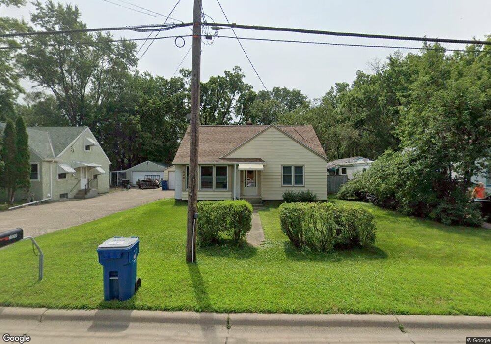
2000 County Road F E Saint Paul, MN 55110
Estimated Value: $301,152 - $358,000
3
Beds
1
Bath
1,061
Sq Ft
$314/Sq Ft
Est. Value
About This Home
This home is located at 2000 County Road F E, Saint Paul, MN 55110 and is currently estimated at $333,538, approximately $314 per square foot. 2000 County Road F E is a home located in Ramsey County with nearby schools including Lakeaires Elementary School, Sunrise Park Middle School, and Liberty Classical Academy.
Ownership History
Date
Name
Owned For
Owner Type
Purchase Details
Closed on
Dec 6, 2022
Sold by
Bores Kristin Marie
Bought by
Bores Martin Theodore
Current Estimated Value
Purchase Details
Closed on
Jun 18, 2015
Sold by
Bores Martin T and Bores Kritin M
Bought by
Bores Martin T and Bores Kristin M
Home Financials for this Owner
Home Financials are based on the most recent Mortgage that was taken out on this home.
Original Mortgage
$132,000
Interest Rate
3.82%
Mortgage Type
New Conventional
Create a Home Valuation Report for This Property
The Home Valuation Report is an in-depth analysis detailing your home's value as well as a comparison with similar homes in the area
Home Values in the Area
Average Home Value in this Area
Purchase History
| Date | Buyer | Sale Price | Title Company |
|---|---|---|---|
| Bores Martin Theodore | -- | -- | |
| Bores Martin T | $515 | Cambria Title |
Source: Public Records
Mortgage History
| Date | Status | Borrower | Loan Amount |
|---|---|---|---|
| Previous Owner | Bores Martin T | $132,000 |
Source: Public Records
Tax History Compared to Growth
Tax History
| Year | Tax Paid | Tax Assessment Tax Assessment Total Assessment is a certain percentage of the fair market value that is determined by local assessors to be the total taxable value of land and additions on the property. | Land | Improvement |
|---|---|---|---|---|
| 2025 | $3,308 | $288,700 | $76,800 | $211,900 |
| 2023 | $3,308 | $260,600 | $76,800 | $183,800 |
| 2022 | $2,456 | $231,300 | $76,800 | $154,500 |
| 2021 | $2,428 | $197,600 | $76,800 | $120,800 |
| 2020 | $2,332 | $200,200 | $76,800 | $123,400 |
| 2019 | $2,114 | $182,300 | $76,800 | $105,500 |
| 2018 | $2,180 | $177,800 | $76,800 | $101,000 |
| 2017 | $1,916 | $187,200 | $85,300 | $101,900 |
| 2016 | $2,082 | $0 | $0 | $0 |
| 2015 | $1,908 | $169,900 | $80,200 | $89,700 |
| 2014 | $1,994 | $0 | $0 | $0 |
Source: Public Records
Map
Nearby Homes
- 4107 White Bear Ave N
- 4181 White Bear Ave N
- 4035 Highland Ave
- 2184 Floral Dr
- 3979 Mcknight Rd N
- 3982 Mcknight Rd N
- 3915 Mcknight Rd N
- 4012 Cranbrook Dr
- 2314 Birch St
- 3750 Van Dyke St
- 1828 Whitaker St
- 1795 Cheri Ct
- 2075 Dorothy Ave
- 1794 Cheri Ct
- 1792 Cheri Ct
- 2086 Dorothy Ave
- 3823 Linden Ave
- 3743 Kenny Ln
- 3714 Kenny Ln
- 2431 S Shore Blvd
- 1994 County Road F E
- 2004 County Road F E
- 4075 White Bear Ave N
- 4065 White Bear Ave N
- 1982 County Road F E
- 4055 White Bear Ave N
- 1999 County Road F E
- 1988 County Road F E
- 2005 Nicholas Ct
- 4095 White Bear Ave N
- 1999 Nicholas Ct
- 4047 White Bear Ave N
- 1981 County Road F E
- 1995 Nicholas Ct
- 1984 County Road F E
- 1969 County Road F E
- 4066 White Bear Ave
- 4066 White Bear Ave N
- 4066 White Bear Ave N
- 4066 & 4070 White Bear Ave Ave