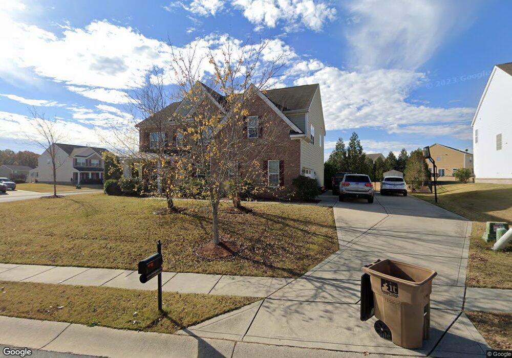
2001 Blue Range Rd Indian Trail, NC 28079
Estimated Value: $540,000 - $593,000
5
Beds
3
Baths
3,484
Sq Ft
$162/Sq Ft
Est. Value
About This Home
This home is located at 2001 Blue Range Rd, Indian Trail, NC 28079 and is currently estimated at $566,079, approximately $162 per square foot. 2001 Blue Range Rd is a home located in Union County with nearby schools including Poplin Elementary School, Porter Ridge Middle School, and Porter Ridge High School.
Ownership History
Date
Name
Owned For
Owner Type
Purchase Details
Closed on
Aug 22, 2008
Sold by
Centex Homes
Bought by
Mcnally Stephen William and Mcnally Laura S
Current Estimated Value
Home Financials for this Owner
Home Financials are based on the most recent Mortgage that was taken out on this home.
Original Mortgage
$214,675
Outstanding Balance
$140,828
Interest Rate
6.32%
Mortgage Type
Unknown
Estimated Equity
$425,251
Create a Home Valuation Report for This Property
The Home Valuation Report is an in-depth analysis detailing your home's value as well as a comparison with similar homes in the area
Home Values in the Area
Average Home Value in this Area
Purchase History
| Date | Buyer | Sale Price | Title Company |
|---|---|---|---|
| Mcnally Stephen William | $268,500 | None Available |
Source: Public Records
Mortgage History
| Date | Status | Borrower | Loan Amount |
|---|---|---|---|
| Open | Mcnally Stephen William | $214,675 |
Source: Public Records
Tax History Compared to Growth
Tax History
| Year | Tax Paid | Tax Assessment Tax Assessment Total Assessment is a certain percentage of the fair market value that is determined by local assessors to be the total taxable value of land and additions on the property. | Land | Improvement |
|---|---|---|---|---|
| 2024 | $3,121 | $372,200 | $65,800 | $306,400 |
| 2023 | $3,094 | $372,200 | $65,800 | $306,400 |
| 2022 | $3,094 | $372,200 | $65,800 | $306,400 |
| 2021 | $3,052 | $367,000 | $65,800 | $301,200 |
| 2020 | $2,020 | $259,100 | $39,000 | $220,100 |
| 2019 | $2,553 | $259,100 | $39,000 | $220,100 |
| 2018 | $2,020 | $259,100 | $39,000 | $220,100 |
| 2017 | $2,686 | $259,100 | $39,000 | $220,100 |
| 2016 | $2,633 | $259,100 | $39,000 | $220,100 |
| 2015 | $2,145 | $259,100 | $39,000 | $220,100 |
| 2014 | $2,107 | $294,970 | $40,000 | $254,970 |
Source: Public Records
Map
Nearby Homes
- 5003 Singletree Ln
- 1003 Dairy Glen Rd
- 1008 Wellscroft Rd
- 1007 Green Terra Rd
- 1014 Garden Web Rd
- 1014 Puddle Pond Rd
- 1022 Merganser Way
- 2015 Canvasback Way
- Washington Plan at Sanctuary at Southgate
- Jasmine Plan at Sanctuary at Southgate
- Collin Plan at Sanctuary at Southgate - Townhomes
- Verwood Plan at Sanctuary at Southgate
- Hampshire Plan at Sanctuary at Southgate
- London Plan at Sanctuary at Southgate
- Kristin Plan at Sanctuary at Southgate
- Blake Plan at Sanctuary at Southgate - Townhomes
- Coastal Plan at Sanctuary at Southgate
- Fleetwood Plan at Sanctuary at Southgate
- Graymount Plan at Sanctuary at Southgate
- Azalea Plan at Sanctuary at Southgate
- 2003 Blue Range Rd
- 1004 Gwinmar Rd
- 7012 Farm Pond Rd
- 1002 Gwinmar Rd
- 1002 Gwinmar Rd Unit FS221
- 2005 Blue Range Rd
- 1006 Gwinmar Rd
- 2002 Blue Range Rd
- 7010 Farm Pond Rd
- 2004 Blue Range Rd
- 7008 Farm Pond Rd
- 7006 Farm Pond Rd Unit 424
- 1008 Gwinmar Rd
- 2007 Blue Range Rd
- 2006 Blue Range Rd
- 1005 Blue Range Rd
- 7004 Farm Pond Rd
- 7002 Farm Pond Rd
- 1010 Gwinmar Rd
- 1003 Gwinmar Rd