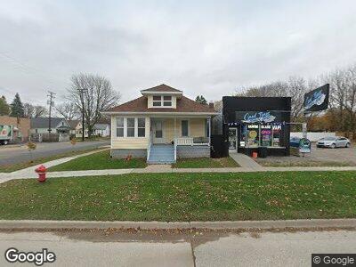
2002 10th St Unit 2004 Port Huron, MI 48060
Downtown Port Huron NeighborhoodEstimated Value: $122,720 - $154,000
--
Bed
--
Bath
1,660
Sq Ft
$83/Sq Ft
Est. Value
About This Home
This home is located at 2002 10th St Unit 2004, Port Huron, MI 48060 and is currently estimated at $137,930, approximately $83 per square foot. 2002 10th St Unit 2004 is a home located in St. Clair County with nearby schools including Woodrow Wilson Elementary School, Central Middle School, and Port Huron High School.
Ownership History
Date
Name
Owned For
Owner Type
Purchase Details
Closed on
Apr 22, 2022
Sold by
Siudara James A
Bought by
Parmann Edward J
Current Estimated Value
Purchase Details
Closed on
Oct 18, 2021
Sold by
Murray Alexander Llc
Bought by
Siudara James A
Purchase Details
Closed on
Feb 9, 2007
Sold by
Siudara James A and Siudara Cynthia K
Bought by
Murray Alexander Llc
Home Financials for this Owner
Home Financials are based on the most recent Mortgage that was taken out on this home.
Original Mortgage
$67,700
Interest Rate
7.5%
Mortgage Type
New Conventional
Create a Home Valuation Report for This Property
The Home Valuation Report is an in-depth analysis detailing your home's value as well as a comparison with similar homes in the area
Home Values in the Area
Average Home Value in this Area
Purchase History
| Date | Buyer | Sale Price | Title Company |
|---|---|---|---|
| Parmann Edward J | $130,000 | None Listed On Document | |
| Siudara James A | -- | None Available | |
| Murray Alexander Llc | -- | Lapeer County Abstract & Tit | |
| Siudara James A | -- | None Available |
Source: Public Records
Mortgage History
| Date | Status | Borrower | Loan Amount |
|---|---|---|---|
| Previous Owner | Siudara James A | $67,700 |
Source: Public Records
Tax History Compared to Growth
Tax History
| Year | Tax Paid | Tax Assessment Tax Assessment Total Assessment is a certain percentage of the fair market value that is determined by local assessors to be the total taxable value of land and additions on the property. | Land | Improvement |
|---|---|---|---|---|
| 2024 | $3,493 | $65,800 | $0 | $0 |
| 2023 | $3,308 | $56,600 | $0 | $0 |
| 2022 | $1,791 | $48,200 | $0 | $0 |
| 2021 | $1,710 | $40,800 | $0 | $0 |
| 2020 | $1,717 | $36,400 | $36,400 | $0 |
| 2019 | $1,686 | $26,100 | $0 | $0 |
| 2018 | $1,648 | $26,100 | $0 | $0 |
| 2017 | $1,513 | $25,400 | $0 | $0 |
| 2016 | $1,345 | $25,400 | $0 | $0 |
| 2015 | $1,427 | $24,900 | $24,900 | $0 |
| 2014 | $1,427 | $26,500 | $26,500 | $0 |
| 2013 | -- | $28,300 | $0 | $0 |
Source: Public Records
Map
Nearby Homes
- 2002 10th St Unit 2004
- 930 Bancroft St
- 2000 10th St
- 2000 10th St Unit 2024
- 926 Bancroft St
- 2005 10th St
- 2003 10th St
- 920 Bancroft St
- 925 Bancroft St
- 923 Bancroft St
- 2015 10th St
- 1016 Bancroft St
- 921 Bancroft St
- 2017 10th St
- 1923 10th St
- 914 Bancroft St
- 913 Bancroft St
- 1927 10th St
- 2001 9th St
- 1917 10th St