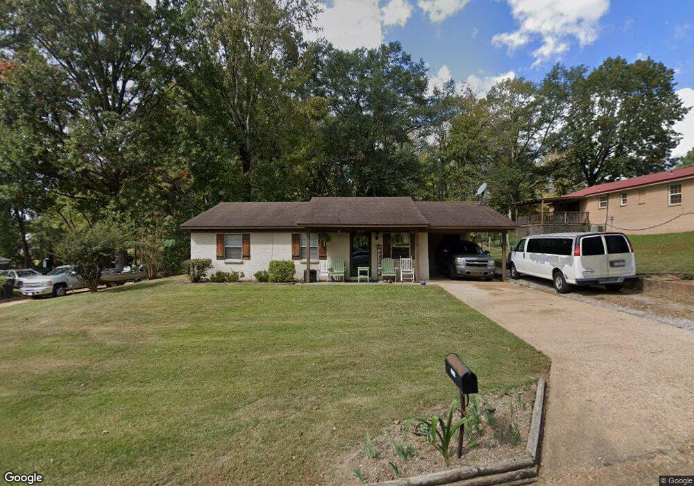
2005 Brandywine Dr Oxford, MS 38655
Estimated Value: $172,000 - $234,798
3
Beds
2
Baths
1,133
Sq Ft
$179/Sq Ft
Est. Value
About This Home
This home is located at 2005 Brandywine Dr, Oxford, MS 38655 and is currently estimated at $202,450, approximately $178 per square foot. 2005 Brandywine Dr is a home located in Lafayette County with nearby schools including Bramlett Elementary School, Della Davidson Elementary School, and Central Elementary School.
Ownership History
Date
Name
Owned For
Owner Type
Purchase Details
Closed on
Oct 22, 2009
Sold by
Jacoby Trace and Alford Tracy
Bought by
Rose Arlee and Rose Debra
Current Estimated Value
Home Financials for this Owner
Home Financials are based on the most recent Mortgage that was taken out on this home.
Original Mortgage
$79,030
Outstanding Balance
$51,421
Interest Rate
5.01%
Mortgage Type
New Conventional
Estimated Equity
$151,029
Purchase Details
Closed on
Nov 30, 2006
Sold by
Wells Fargo Financial Mississippi 2 Inc
Bought by
Jacoby Tracy
Home Financials for this Owner
Home Financials are based on the most recent Mortgage that was taken out on this home.
Original Mortgage
$59,693
Interest Rate
6.19%
Mortgage Type
New Conventional
Create a Home Valuation Report for This Property
The Home Valuation Report is an in-depth analysis detailing your home's value as well as a comparison with similar homes in the area
Home Values in the Area
Average Home Value in this Area
Purchase History
| Date | Buyer | Sale Price | Title Company |
|---|---|---|---|
| Rose Arlee | -- | None Available | |
| Jacoby Tracy | -- | None Available |
Source: Public Records
Mortgage History
| Date | Status | Borrower | Loan Amount |
|---|---|---|---|
| Open | Rose Arlee | $79,030 | |
| Previous Owner | Jacoby Tracy | $59,693 |
Source: Public Records
Tax History Compared to Growth
Tax History
| Year | Tax Paid | Tax Assessment Tax Assessment Total Assessment is a certain percentage of the fair market value that is determined by local assessors to be the total taxable value of land and additions on the property. | Land | Improvement |
|---|---|---|---|---|
| 2024 | $692 | $7,507 | $0 | $0 |
| 2023 | $692 | $7,264 | $0 | $0 |
| 2022 | $651 | $7,264 | $0 | $0 |
| 2021 | $114 | $7,264 | $0 | $0 |
| 2020 | $107 | $7,185 | $0 | $0 |
| 2019 | $107 | $7,185 | $0 | $0 |
| 2018 | $122 | $7,185 | $0 | $0 |
| 2017 | $122 | $7,185 | $0 | $0 |
| 2016 | $108 | $6,976 | $0 | $0 |
| 2015 | -- | $6,976 | $0 | $0 |
| 2014 | -- | $6,976 | $0 | $0 |
Source: Public Records
Map
Nearby Homes
- 1016 Suncrest Dr
- 0 Cannon Rd 5 8 Ac Tract 2 Unit 161584
- 0 Cannon Rd Tract 1 10 06 Ac
- 0 Cannon Rd 10 06 Ac Tract 1
- 36A County Road 2003
- Cannon Rd
- 0
- 0
- 104 Hedges Cove
- 108 Hedges Cove
- 720 Primrose Dr
- 203 Mississippi 6
- Oxford
- 1126 Shelia Dr
- 1560 Larhonda Dr
- 125 Slack Rd
- 2333 University Ave
- tbd Hwy 6 W
- 139 Cr 427
- 334 Sunflower Ln
- 2007 Briarfield Cove
- 2003 Brandywine Dr
- 2009 Briarfield Cove
- 2008 Brandywine Dr
- 2006 Brandywine Dr
- 2001 Brandywine Dr
- 2004 Brandywine Dr
- 2012 Brandywine Dr
- 2010 Brandywine Dr
- 2017 Briarfield Cove
- 1001 Suncrest St
- 2014 Brandywine Dr
- 1001 Suncrest Dr
- 1005 Suncrest St
- 1007 Suncrest St
- 2011 Briarfield Cove
- 1003 Suncrest St
- 2015 Briarfield Cove
- 2002 Brandywine Dr
- 2013 Briarfield Cove