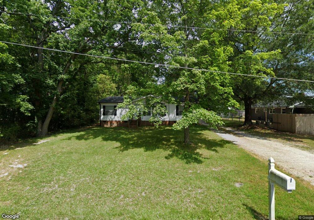
2006 Waldo St High Point, NC 27262
Greater High Point NeighborhoodEstimated Value: $129,394 - $199,000
3
Beds
2
Baths
1,220
Sq Ft
$127/Sq Ft
Est. Value
About This Home
This home is located at 2006 Waldo St, High Point, NC 27262 and is currently estimated at $154,349, approximately $126 per square foot. 2006 Waldo St is a home located in Guilford County with nearby schools including Oak View Elementary School, Ferndale Middle School, and High Point Central High School.
Ownership History
Date
Name
Owned For
Owner Type
Purchase Details
Closed on
Sep 21, 2018
Sold by
Collins Kay G and Collins James D
Bought by
Graves Ricky S
Current Estimated Value
Home Financials for this Owner
Home Financials are based on the most recent Mortgage that was taken out on this home.
Original Mortgage
$70,695
Outstanding Balance
$61,010
Interest Rate
4.5%
Mortgage Type
FHA
Estimated Equity
$93,339
Purchase Details
Closed on
Mar 22, 1995
Bought by
Tucker Kay Denise
Create a Home Valuation Report for This Property
The Home Valuation Report is an in-depth analysis detailing your home's value as well as a comparison with similar homes in the area
Home Values in the Area
Average Home Value in this Area
Purchase History
| Date | Buyer | Sale Price | Title Company |
|---|---|---|---|
| Graves Ricky S | $72,000 | None Available | |
| Tucker Kay Denise | -- | -- |
Source: Public Records
Mortgage History
| Date | Status | Borrower | Loan Amount |
|---|---|---|---|
| Open | Graves Ricky S | $70,695 |
Source: Public Records
Tax History
| Year | Tax Paid | Tax Assessment Tax Assessment Total Assessment is a certain percentage of the fair market value that is determined by local assessors to be the total taxable value of land and additions on the property. | Land | Improvement |
|---|---|---|---|---|
| 2025 | $1,006 | $73,000 | $15,000 | $58,000 |
| 2024 | $1,006 | $73,000 | $15,000 | $58,000 |
| 2023 | $1,006 | $73,000 | $15,000 | $58,000 |
| 2022 | $984 | $73,000 | $15,000 | $58,000 |
| 2021 | $755 | $54,800 | $15,000 | $39,800 |
| 2020 | $755 | $54,800 | $15,000 | $39,800 |
| 2019 | $755 | $54,800 | $0 | $0 |
| 2018 | $751 | $54,800 | $0 | $0 |
| 2017 | $751 | $54,800 | $0 | $0 |
| 2016 | $763 | $54,400 | $0 | $0 |
| 2015 | $767 | $54,400 | $0 | $0 |
| 2014 | $780 | $54,400 | $0 | $0 |
Source: Public Records
Map
Nearby Homes
- 914 Flicker Ln
- 416 Greenwood Dr
- 1001 Nuthatch Ct
- 506 Greenwood Dr
- 101 Oxford Place Unit 19
- 709 Overbrook Dr
- 708 Rockspring Rd
- 1508 Wendover Dr
- 629 Rockspring Rd
- 607 Rockspring Rd
- 619 W Lexington Ave
- 1700 Long St
- 204 Northpoint Ave Unit C
- 443 W Lexington Ave
- 224 Northpoint Ave Unit E
- 118 Welch Dr
- 207 Northpoint Ave Unit H
- 219 Rockspring Rd
- 1311 Prescott Place
- 744 Celtic Crossing Dr
- 310 Elmhurst Ave
- 302 Elmhurst Ave
- 2003 Waldo St
- 2007 Whitehall St
- 404 Elmhurst Ave
- 300 Elmhurst Ave
- 406 Elmhurst Ave
- 213 Westchester Dr
- 309 Elmhurst Ave
- 305 Homestead Ave
- 408 Elmhurst Ave
- 401 Elmhurst Ave
- 212 Elmhurst Ave
- 301 Elmhurst Ave
- 300 Homestead Ave
- 300 Westchester Dr
- 302 Homestead Ave
- 405 Elmhurst Ave
- 403 Greenwood Dr
- 1912 Waldo St
Your Personal Tour Guide
Ask me questions while you tour the home.