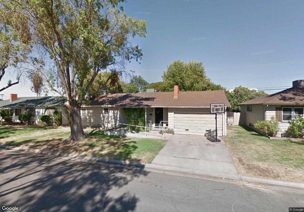
2008 Aloha Way Modesto, CA 95350
Central Modesto NeighborhoodEstimated Value: $316,000 - $395,000
3
Beds
1
Bath
984
Sq Ft
$356/Sq Ft
Est. Value
About This Home
This home is located at 2008 Aloha Way, Modesto, CA 95350 and is currently estimated at $350,591, approximately $356 per square foot. 2008 Aloha Way is a home located in Stanislaus County with nearby schools including Elihu Beard Elementary School, Roosevelt Junior High School, and Grace M. Davis High School.
Ownership History
Date
Name
Owned For
Owner Type
Purchase Details
Closed on
Sep 9, 2021
Sold by
Geary Michael E
Bought by
Geary Michael and Geary Mary Ellen
Current Estimated Value
Purchase Details
Closed on
Dec 13, 1994
Sold by
Lemmons Judith C and The Thelma Hillman 1992 Trust
Bought by
Geary Michael E
Home Financials for this Owner
Home Financials are based on the most recent Mortgage that was taken out on this home.
Original Mortgage
$63,200
Interest Rate
7.15%
Create a Home Valuation Report for This Property
The Home Valuation Report is an in-depth analysis detailing your home's value as well as a comparison with similar homes in the area
Home Values in the Area
Average Home Value in this Area
Purchase History
| Date | Buyer | Sale Price | Title Company |
|---|---|---|---|
| Geary Michael | -- | None Available | |
| Geary Michael E | $79,000 | North American Title Ins Co |
Source: Public Records
Mortgage History
| Date | Status | Borrower | Loan Amount |
|---|---|---|---|
| Closed | Geary Michael E | $63,200 | |
| Closed | Geary Michael E | $7,900 |
Source: Public Records
Tax History Compared to Growth
Tax History
| Year | Tax Paid | Tax Assessment Tax Assessment Total Assessment is a certain percentage of the fair market value that is determined by local assessors to be the total taxable value of land and additions on the property. | Land | Improvement |
|---|---|---|---|---|
| 2025 | $1,551 | $132,673 | $57,099 | $75,574 |
| 2024 | $1,482 | $130,073 | $55,980 | $74,093 |
| 2023 | $1,460 | $127,524 | $54,883 | $72,641 |
| 2022 | $1,425 | $125,024 | $53,807 | $71,217 |
| 2021 | $1,340 | $122,573 | $52,752 | $69,821 |
| 2020 | $1,366 | $121,318 | $52,212 | $69,106 |
| 2019 | $1,335 | $118,940 | $51,189 | $67,751 |
| 2018 | $1,271 | $116,609 | $50,186 | $66,423 |
| 2017 | $1,240 | $114,323 | $49,202 | $65,121 |
| 2016 | $1,217 | $112,083 | $48,238 | $63,845 |
| 2015 | $1,200 | $110,400 | $47,514 | $62,886 |
| 2014 | $1,182 | $108,239 | $46,584 | $61,655 |
Source: Public Records
Map
Nearby Homes
- 2013 Sherwood Ave
- 1921 Sherwood Ave
- 1936 Ralston Ct
- 617 W Granger Ave Unit 43
- 617 W Granger Ave Unit 1
- 900 Dartmouth Ave
- 2517 Fremont Ave
- 2768 Sherwood Ave Unit B
- 1725 Bronson Ave
- 405 Roxbury Ln
- 404 Andover Ln
- 1018 Middleton Ct
- 1905 Wildwood Dr
- 230 W Rumble Rd Unit B
- 806 Barham Ct
- 2808 Yukon Dr
- 1912 Valle Vista Ave
- 2809 Yukon Dr
- 1819 Monte Carlo Ave
- 1344 Magnolia Ave