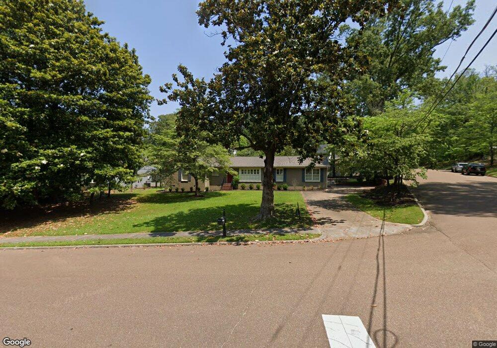
201 Longest Rd Oxford, MS 38655
Estimated Value: $448,000 - $1,184,000
4
Beds
3
Baths
2,326
Sq Ft
$319/Sq Ft
Est. Value
About This Home
This home is located at 201 Longest Rd, Oxford, MS 38655 and is currently estimated at $742,498, approximately $319 per square foot. 201 Longest Rd is a home located in Lafayette County with nearby schools including Central Elementary School, Bramlett Elementary School, and Della Davidson Elementary School.
Ownership History
Date
Name
Owned For
Owner Type
Purchase Details
Closed on
May 13, 2020
Sold by
Schaffenburg Karl C and Schaffenburg Elizabeth B
Bought by
Abraham Ralph S and Abraham Sarah Anne
Current Estimated Value
Home Financials for this Owner
Home Financials are based on the most recent Mortgage that was taken out on this home.
Original Mortgage
$533,564
Interest Rate
3.3%
Mortgage Type
Commercial
Create a Home Valuation Report for This Property
The Home Valuation Report is an in-depth analysis detailing your home's value as well as a comparison with similar homes in the area
Home Values in the Area
Average Home Value in this Area
Purchase History
| Date | Buyer | Sale Price | Title Company |
|---|---|---|---|
| Abraham Ralph S | -- | None Available |
Source: Public Records
Mortgage History
| Date | Status | Borrower | Loan Amount |
|---|---|---|---|
| Closed | Abraham Ralph S | $200,000 | |
| Closed | Sumner Abraham Ralph | $1,655,400 | |
| Closed | Abraham Ralph Sumner | $570,865 | |
| Closed | Abraham Ralph S | $472,000 | |
| Closed | Abraham Ralph S | $71,000 | |
| Closed | Abraham Ralph S | $533,564 | |
| Previous Owner | Duperier Elizabeth | $417,000 | |
| Previous Owner | Schaffenburg Karl C | $255,000 | |
| Previous Owner | Custom Renovations By Todd Paine Llc | $239,000 |
Source: Public Records
Tax History Compared to Growth
Tax History
| Year | Tax Paid | Tax Assessment Tax Assessment Total Assessment is a certain percentage of the fair market value that is determined by local assessors to be the total taxable value of land and additions on the property. | Land | Improvement |
|---|---|---|---|---|
| 2024 | $4,262 | $34,535 | $0 | $0 |
| 2023 | $4,262 | $34,535 | $0 | $0 |
| 2022 | $4,193 | $34,535 | $0 | $0 |
| 2021 | $1,092 | $34,535 | $0 | $0 |
| 2020 | $948 | $31,414 | $0 | $0 |
| 2019 | $948 | $31,414 | $0 | $0 |
| 2018 | $948 | $31,414 | $0 | $0 |
| 2017 | $948 | $31,414 | $0 | $0 |
| 2016 | $842 | $29,398 | $0 | $0 |
| 2015 | -- | $29,398 | $0 | $0 |
| 2014 | -- | $29,398 | $0 | $0 |
Source: Public Records
Map
Nearby Homes
- 207 Longest Rd
- 181 Cullen Rd
- 181 Cullen Rd
- 108 Eagle Spring Rd
- 111 Longest Rd
- 100 Cullen Rd
- 211 Longest Rd
- 206 Longest Rd
- 201 Cullen Rd
- 200 Longest Rd
- 200 Eagle Springs Rd
- 200 Eagle Spring Rd
- 108 Cullen Rd
- 210 Longest Rd
- 105 Longest Rd
- 207 Cullen Rd
- 206 Eagle Spring Rd
- 214 Longest Rd
- 109 Eagle Springs Rd
- 200 Cullen Rd