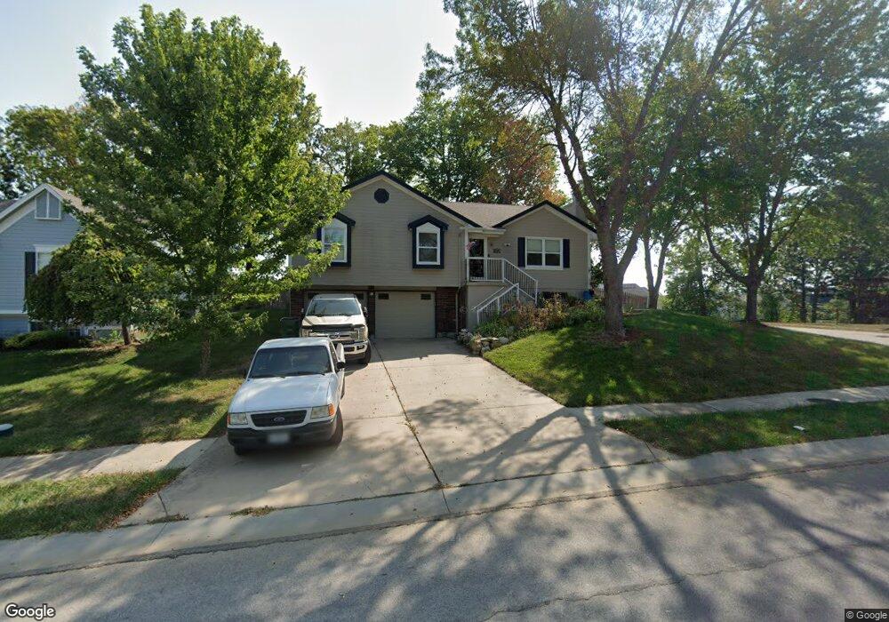
201 NW Cody Dr Lees Summit, MO 64081
Estimated Value: $355,742 - $388,000
3
Beds
3
Baths
1,629
Sq Ft
$227/Sq Ft
Est. Value
About This Home
This home is located at 201 NW Cody Dr, Lees Summit, MO 64081 and is currently estimated at $370,186, approximately $227 per square foot. 201 NW Cody Dr is a home located in Jackson County with nearby schools including Cedar Creek Elementary School, Pleasant Lea Middle School, and Lee's Summit Senior High School.
Ownership History
Date
Name
Owned For
Owner Type
Purchase Details
Closed on
Nov 3, 2021
Sold by
Alvarez Gilbert Tapia and Alvarez Gail A
Bought by
Alvarez Gilbert T and Alvarez Gail A
Current Estimated Value
Purchase Details
Closed on
Sep 28, 2016
Sold by
Housing & Urban Development
Bought by
Alvarez Gilbert and Alvarez Gail
Home Financials for this Owner
Home Financials are based on the most recent Mortgage that was taken out on this home.
Original Mortgage
$154,226
Outstanding Balance
$123,387
Interest Rate
3.48%
Estimated Equity
$246,799
Purchase Details
Closed on
Sep 28, 1998
Sold by
Alvarez Gilbert T and Alvarez Gail A
Bought by
Alvarez Gilbert Tapia and Alvarez Gail A
Home Financials for this Owner
Home Financials are based on the most recent Mortgage that was taken out on this home.
Original Mortgage
$94,324
Interest Rate
6.92%
Mortgage Type
VA
Create a Home Valuation Report for This Property
The Home Valuation Report is an in-depth analysis detailing your home's value as well as a comparison with similar homes in the area
Home Values in the Area
Average Home Value in this Area
Purchase History
| Date | Buyer | Sale Price | Title Company |
|---|---|---|---|
| Alvarez Gilbert T | -- | None Available | |
| Alvarez Gilbert | -- | -- | |
| Alvarez Gilbert Tapia | -- | Chicago Title Insurance Co |
Source: Public Records
Mortgage History
| Date | Status | Borrower | Loan Amount |
|---|---|---|---|
| Open | Alvarez Gilbert | $154,226 | |
| Closed | Alvarez Gilbert | -- | |
| Previous Owner | Alvarez Gilbert Tapia | $94,324 |
Source: Public Records
Tax History
| Year | Tax Paid | Tax Assessment Tax Assessment Total Assessment is a certain percentage of the fair market value that is determined by local assessors to be the total taxable value of land and additions on the property. | Land | Improvement |
|---|---|---|---|---|
| 2025 | $6,744 | $52,012 | $9,133 | $42,879 |
| 2024 | $6,714 | $56,584 | $8,052 | $48,532 |
| 2023 | $6,714 | $56,584 | $7,921 | $48,663 |
| 2022 | $5,833 | $39,330 | $6,821 | $32,509 |
| 2021 | $5,893 | $39,330 | $6,821 | $32,509 |
| 2020 | $5,738 | $37,510 | $6,821 | $30,689 |
| 2019 | $5,639 | $37,510 | $6,821 | $30,689 |
| 2018 | $2,578 | $32,408 | $3,192 | $29,216 |
| 2016 | $2,344 | $26,600 | $4,351 | $22,249 |
Source: Public Records
Map
Nearby Homes
- 209 NW Cody Dr
- 2214 NW Killarney Ln
- 2127 NW Killarney Ln
- 2123 NW Killarney Ln
- 2090 NW O'Brien Rd
- 2086 NW O'Brien Rd
- 248 SW Winterpark Cir
- 433 NW Kaylea Ct
- 2122 NW Ashurst Dr
- 334 NW Ambersham Dr
- 130 NW Ambersham Dr
- 2032 SW British Dr
- 125 SW Tess Dr
- 2114 NW Killarney Ln
- 129 NW Morton Dr
- 2635 NW Ashurst Ln
- 2809 NW Audubon Ln
- 321 NW Nutall Dr
- 313 SW Ensley Ln
- 305 SW Marion Ln
- 205 NW Cody Dr
- 129 NW Cody Dr
- 208 NW Cody Dr
- 132 NW Cody Dr
- 125 NW Cody Dr
- 128 NW Cody Dr
- 212 NW Cody Dr
- 213 NW Cody Dr
- 237 NW Whitlock Dr
- 124 NW Cody Dr
- 121 NW Cody Dr
- 241 NW Whitlock Dr
- 217 NW Cody Dr
- 117 NW Cody Dr
- 233 NW Whitlock Dr
- 120 NW Cody Dr
- 244 NW Whitlock Dr
- 220 NW Cody Dr
- 2225 NW Killarney Ln
- 229 NW Whitlock Dr
Your Personal Tour Guide
Ask me questions while you tour the home.