


201 S 11th St Unit 2500 Minneapolis, MN 55403
Downtown West NeighborhoodEstimated payment $15,137/month
Highlights
- 24-Hour Guard
- 1-Story Property
- Combination Kitchen and Dining Room
- Great Room
- Forced Air Heating and Cooling System
- Baseboard Heating
About This Home
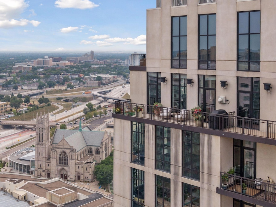
Welcome to Ivy #2500, the most stunning penthouse within the Ivy Residences. Enjoy an open floor plan with exceptional finishes, with floor-to-ceiling windows showcasing stunning views of Downtown and the city in three directions. The city is at your fingertips, with 3 restaurants, a top rated full-service spa, a 24 hour concierge and hotel amenities, all in-building. Some of the best restaurants in the state are within walking distance, along with Orchestra Hall, and much more, all in the heart of Downtown Minneapolis. This condo offers an unparalleled city lifestyle in true luxury fashion.

Property Details
Home Type
- Condominium
Est. Annual Taxes
- $26,166
Year Built
- Built in 2007
HOA Fees
- $4,005 Monthly HOA Fees
Parking
- 3 Car Garage
- Secure Parking
Interior Spaces
- 3,813 Sq Ft Home
- 1-Story Property
- Electric Fireplace
- Great Room
- Combination Kitchen and Dining Room
- Basement
- Block Basement Construction
- Washer and Dryer Hookup
Kitchen
- Range
- Microwave
- Freezer
- Dishwasher
- Disposal
Bedrooms and Bathrooms
- 2 Bedrooms
Home Security
Accessible Home Design
- Accessible Elevator Installed
Utilities
- Forced Air Heating and Cooling System
- Vented Exhaust Fan
- Baseboard Heating
- Cable TV Available
Listing and Financial Details
- Assessor Parcel Number 2702924140608
Community Details
Overview
- Association fees include air conditioning, maintenance structure, cable TV, electricity, heating, internet, ground maintenance, professional mgmt, security, shared amenities, snow removal
- First Service Residential Association, Phone Number (952) 277-2700
- High-Rise Condominium
- Cic 1431 Ivy Resdidence Subdivision
Security
- 24-Hour Guard
- Fire Sprinkler System
Map
Home Values in the Area
Average Home Value in this Area
Tax History
| Year | Tax Paid | Tax Assessment Tax Assessment Total Assessment is a certain percentage of the fair market value that is determined by local assessors to be the total taxable value of land and additions on the property. | Land | Improvement |
|---|---|---|---|---|
| 2024 | $26,263 | $1,527,000 | $51,000 | $1,476,000 |
| 2023 | $25,724 | $1,694,000 | $56,000 | $1,638,000 |
| 2022 | $28,371 | $1,726,000 | $56,000 | $1,670,000 |
| 2021 | $27,314 | $1,756,000 | $53,300 | $1,702,700 |
| 2020 | $28,082 | $1,756,000 | $53,300 | $1,702,700 |
| 2019 | $28,859 | $1,672,500 | $45,700 | $1,626,800 |
| 2018 | $27,120 | $1,672,500 | $45,700 | $1,626,800 |
| 2017 | $26,082 | $1,474,500 | $35,600 | $1,438,900 |
| 2016 | $25,355 | $1,400,000 | $35,600 | $1,364,400 |
| 2015 | $16,921 | $922,500 | $35,600 | $886,900 |
| 2014 | -- | $922,500 | $35,600 | $886,900 |
Property History
| Date | Event | Price | List to Sale | Price per Sq Ft |
|---|---|---|---|---|
| 09/25/2025 09/25/25 | Price Changed | $1,699,900 | -5.6% | $446 / Sq Ft |
| 08/22/2025 08/22/25 | For Sale | $1,799,900 | -- | $472 / Sq Ft |
Purchase History
| Date | Type | Sale Price | Title Company |
|---|---|---|---|
| Interfamily Deed Transfer | -- | None Available | |
| Limited Warranty Deed | $1,250,000 | Titlenexus Llc | |
| Warranty Deed | -- | First American Title Ins Co |
Source: NorthstarMLS
MLS Number: 6776978
APN: 27-029-24-14-0608
Disclaimer: Certain information contained herein is derived from information provided by parties other than Homes.com. All information provided is deemed reliable, but is not guaranteed to be accurate and should be independently verified.
![]() Based on information submitted to the MLS GRID. All data is obtained from various sources and may not have been verified by broker or MLS GRID. Supplied Open House Information is subject to change without notice. All information should be independently reviewed and verified for accuracy. Properties may or may not be listed by the office/agent presenting the information. Some IDX listings have been excluded from this website.
Based on information submitted to the MLS GRID. All data is obtained from various sources and may not have been verified by broker or MLS GRID. Supplied Open House Information is subject to change without notice. All information should be independently reviewed and verified for accuracy. Properties may or may not be listed by the office/agent presenting the information. Some IDX listings have been excluded from this website.
The Digital Millennium Copyright Act of 1998, 17 U.S.C. § 512 (the “DMCA”) provides recourse for copyright owners who believe that material appearing on the Internet infringes their rights under U.S. copyright law. If you believe in good faith that any content or material made available in connection with our website or services infringes your copyright, you (or your agent) may send us a notice requesting that the content or material be removed, or access to it blocked.
Notices must be sent in writing by email to DMCAnotice@MLSGrid.com.
The DMCA requires that your notice of alleged copyright infringement include the following information:
(1) description of the copyrighted work that is the subject of claimed infringement;
(2) description of the alleged infringing content and information sufficient to permit us to locate the content;
(3) contact information for you, including your address, telephone number and email address;
(4) a statement by you that you have a good faith belief that the content in the manner complained of is not authorized by the copyright owner, or its agent, or by the operation of any law;
(5) a statement by you, signed under penalty of perjury, that the information in the notification is accurate and that you have the authority to enforce the copyrights that are claimed to be infringed; and
(6) a physical or electronic signature of the copyright owner or a person authorized to act on the copyright owner’s behalf. Failure to include all of the above information may result in the delay of the processing of your complaint.
- 201 S 11th St Unit 1040
- 201 S 11th St Unit 530
- 201 S 11th St Unit 1000
- 201 S 11th St Unit 830
- 201 S 11th St Unit 1440
- 201 S 11th St Unit 2100
- 201 S 11th St Unit 1400
- 201 S 11th St Unit 1700
- 500 E Grant St Unit 1102
- 500 E Grant St Unit 709
- 500 E Grant St Unit 907
- 500 E Grant St Unit 807
- 500 E Grant St Unit 704
- 500 E Grant St Unit 1507
- 500 E Grant St Unit 1711
- 1200 Nicollet Mall Unit 606
- 1200 Nicollet Mall Unit 507
- 1200 Nicollet Mall Unit 426
- 1225 Lasalle Ave Unit 1501
- 1225 Lasalle Ave Unit 501
- 201 S 11th St Unit 530
- 201 S 11th St Unit 1700
- 1117 Marquette Ave
- 95 S 10th St
- 1314 Marquette Ave
- 500 E Grant St Unit 708
- 500 E Grant St Unit 2409
- 500 E Grant St Unit 209
- 90 S 9th St
- 1200 Nicollet Mall Unit 218
- 1200 Nicollet Mall Unit 215
- 15 E Grant St
- 1225 Lasalle Ave Unit 2301
- 500 E 14th St
- 515 E Grant St
- 1008 Portland Ave
- 16 E 15th St
- 36 S 9th St
- 1410 Nicollet Ave
- 929 Portland Ave Unit 2501