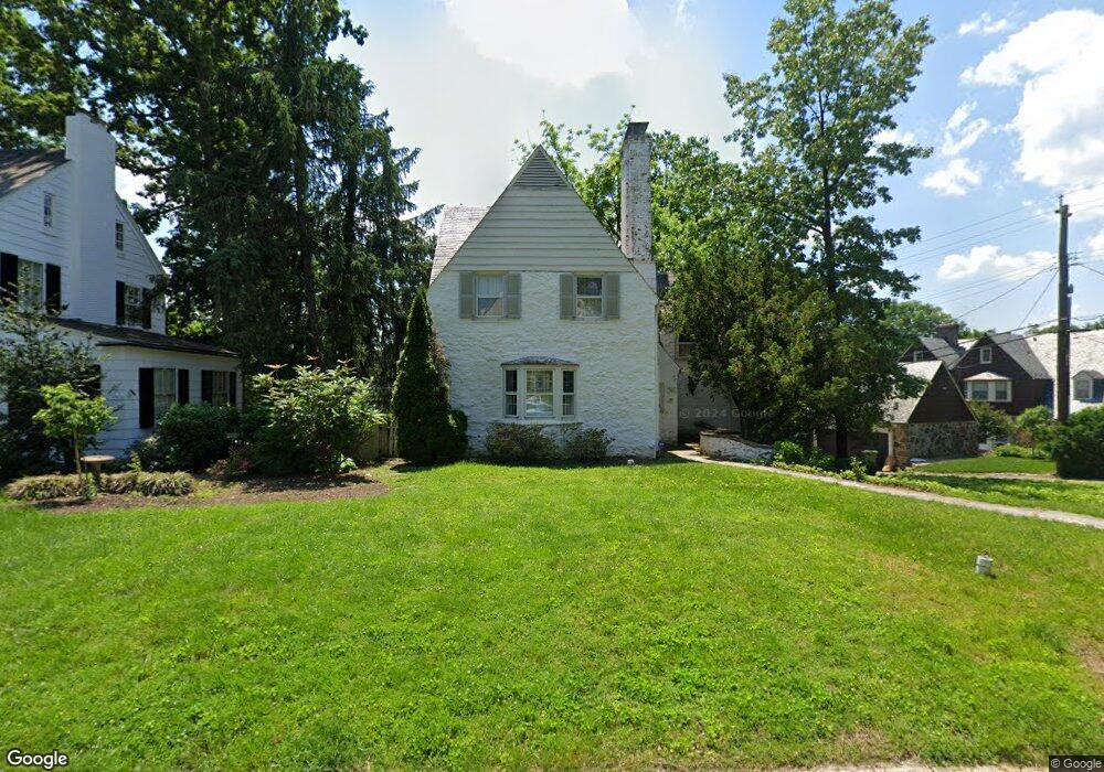
201 Tunbridge Rd Baltimore, MD 21212
Homeland NeighborhoodEstimated Value: $763,978
5
Beds
3
Baths
--
Sq Ft
15,246
Sq Ft Lot
About This Home
This home is located at 201 Tunbridge Rd, Baltimore, MD 21212 and is currently estimated at $763,978. 201 Tunbridge Rd is a home located in Baltimore City with nearby schools including Roland Park Elementary/Middle School, Booker T. Washington Middle School, and Frederick Douglass High School.
Ownership History
Date
Name
Owned For
Owner Type
Purchase Details
Closed on
Mar 23, 2011
Sold by
Drigotas Stephen M and Drigotas Elizabeth E
Bought by
Drigotas Stephen M
Current Estimated Value
Purchase Details
Closed on
Nov 19, 2002
Sold by
Lysaught Geoffrey J
Bought by
Drigotas Stephen M and Drigotas Elizabeth E
Purchase Details
Closed on
Jun 6, 2001
Sold by
Christ Jeffrey E
Bought by
Lysaught Geoffrey J and Lysaught Catherine C
Create a Home Valuation Report for This Property
The Home Valuation Report is an in-depth analysis detailing your home's value as well as a comparison with similar homes in the area
Home Values in the Area
Average Home Value in this Area
Purchase History
| Date | Buyer | Sale Price | Title Company |
|---|---|---|---|
| Drigotas Stephen M | -- | None Available | |
| Drigotas Stephen M | $477,500 | -- | |
| Lysaught Geoffrey J | $450,000 | -- |
Source: Public Records
Tax History
| Year | Tax Paid | Tax Assessment Tax Assessment Total Assessment is a certain percentage of the fair market value that is determined by local assessors to be the total taxable value of land and additions on the property. | Land | Improvement |
|---|---|---|---|---|
| 2025 | $12,291 | $562,333 | -- | -- |
| 2024 | $12,291 | $550,600 | $302,800 | $247,800 |
| 2023 | $11,888 | $534,267 | $0 | $0 |
| 2022 | $11,537 | $517,933 | $0 | $0 |
| 2021 | $11,838 | $501,600 | $302,800 | $198,800 |
| 2020 | $11,137 | $495,733 | $0 | $0 |
| 2019 | $10,944 | $489,867 | $0 | $0 |
| 2018 | $10,969 | $484,000 | $302,800 | $181,200 |
| 2017 | $10,968 | $481,467 | $0 | $0 |
| 2016 | $10,913 | $478,933 | $0 | $0 |
| 2015 | $10,913 | $476,400 | $0 | $0 |
| 2014 | $10,913 | $476,400 | $0 | $0 |
Source: Public Records
Map
Nearby Homes
- 207 Upnor Rd
- 107 Upnor Rd
- 103 Witherspoon Rd
- 212 Saint Dunstans Rd
- 5211 Springlake Way
- 103 Saint Dunstans Rd
- 5 Middleton Ct
- 5405 Springlake Way
- 319 Homeland Southway Unit 2B
- 328 Paddington Rd
- 117 E Northern Pkwy
- 329 Paddington Rd
- 500 Sheridan Ave
- 502 Tunbridge Rd
- 13 Tamworth Rd
- 412 Rosebank Ave
- 518 Sheridan Ave
- 402 Croydon Rd
- 5602 Purlington Way
- 526 Sheridan Ave
- 203 Tunbridge Rd
- 5109 Saint Albans Way
- 5111 Saint Albans Way
- 205 Tunbridge Rd
- 202 Tunbridge Rd
- 204 Tunbridge Rd
- 200 Enfield Rd
- 200 Tunbridge Rd
- 5105 Saint Albans Way
- 207 Tunbridge Rd
- 5201 Saint Albans Way
- 206 Tunbridge Rd
- 202 Enfield Rd
- 208 Tunbridge Rd
- 209 Tunbridge Rd
- 204 Enfield Rd
- 5203 Saint Albans Way
- 5108 Saint Albans Way
- 5106 Saint Albans Way
- 205 Upnor Rd
Your Personal Tour Guide
Ask me questions while you tour the home.