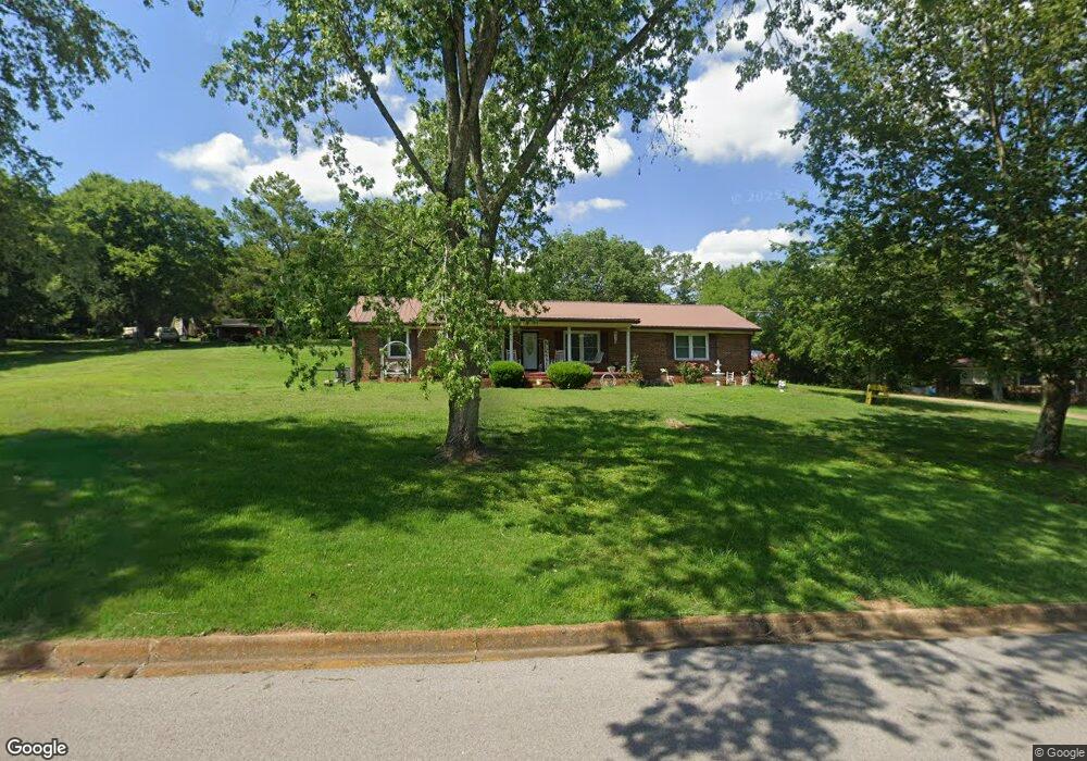
2010 Joann St Pulaski, TN 38478
Estimated Value: $242,665 - $333,000
--
Bed
2
Baths
2,087
Sq Ft
$138/Sq Ft
Est. Value
About This Home
This home is located at 2010 Joann St, Pulaski, TN 38478 and is currently estimated at $288,166, approximately $138 per square foot. 2010 Joann St is a home located in Giles County with nearby schools including Pulaski Elementary School, Southside Elementary School, and Bridgeforth Middle School.
Ownership History
Date
Name
Owned For
Owner Type
Purchase Details
Closed on
Aug 14, 2009
Sold by
Norwood Douglas Donald
Bought by
Ballentine Danny
Current Estimated Value
Purchase Details
Closed on
Jun 13, 2003
Sold by
Norwood Douglas and Norwood Julia
Bought by
Norwood Douglas Liv Trust
Purchase Details
Closed on
Dec 12, 2002
Sold by
Norwood Douglas
Bought by
Norwood Douglas
Purchase Details
Closed on
Sep 20, 2002
Sold by
Norwood Douglas D
Bought by
Norwood The Douglas & Juli
Purchase Details
Closed on
Feb 27, 1991
Bought by
Carvell Garfield
Purchase Details
Closed on
Feb 11, 1991
Bought by
Chapman Kathy J
Purchase Details
Closed on
Oct 26, 1978
Bought by
Thurman Richard Lee and Thurman Pamela
Create a Home Valuation Report for This Property
The Home Valuation Report is an in-depth analysis detailing your home's value as well as a comparison with similar homes in the area
Home Values in the Area
Average Home Value in this Area
Purchase History
| Date | Buyer | Sale Price | Title Company |
|---|---|---|---|
| Ballentine Danny | $125,000 | -- | |
| Norwood Douglas Liv Trust | -- | -- | |
| Norwood Douglas | -- | -- | |
| Norwood The Douglas & Juli | -- | -- | |
| Carvell Garfield | -- | -- | |
| Chapman Kathy J | $65,500 | -- | |
| Thurman Richard Lee | -- | -- |
Source: Public Records
Tax History Compared to Growth
Tax History
| Year | Tax Paid | Tax Assessment Tax Assessment Total Assessment is a certain percentage of the fair market value that is determined by local assessors to be the total taxable value of land and additions on the property. | Land | Improvement |
|---|---|---|---|---|
| 2024 | $1,463 | $60,750 | $7,100 | $53,650 |
| 2023 | $1,463 | $60,750 | $7,100 | $53,650 |
| 2022 | $1,275 | $52,975 | $7,100 | $45,875 |
| 2021 | $1,254 | $37,025 | $4,850 | $32,175 |
| 2020 | $1,254 | $37,025 | $4,850 | $32,175 |
| 2019 | $1,046 | $37,025 | $4,850 | $32,175 |
| 2018 | $1,254 | $37,025 | $4,850 | $32,175 |
| 2017 | $1,254 | $37,025 | $4,850 | $32,175 |
| 2016 | $1,267 | $35,775 | $4,875 | $30,900 |
| 2015 | $1,195 | $35,775 | $4,875 | $30,900 |
| 2014 | $1,195 | $35,770 | $0 | $0 |
Source: Public Records
Map
Nearby Homes
- 0 Industrial Loop Rd
- 132 Stonecreek Dr
- 133 Sunset Dr
- 1814 Vales Mill Rd
- 118 Sunset Dr
- 1660 Vales Mill Rd
- 125 Chicken Creek Rd
- 271 Chicken Creek Rd
- 1 Chicken Creek Rd
- 2400 Chicken Creek Rd
- 1336 Charlotte Ct
- 1041 Jackson Dr
- 720 W Madison St
- 420 Fort Hill Dr
- 210 S 6th St
- 1205 Beverly Dr
- 1202 Parker Dr
- 1811 Columbia Hwy
- 0 N 3rd St
- 1200 Mill St